| [3] |
Name on the Register |
Image |
Date listed[4] |
Location |
City or town |
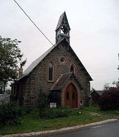
Description |
|---|
| 1 |
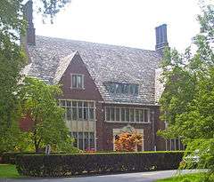
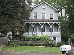
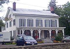
Astor Home for Children |
|
000000001987-07-09-0000July 9, 1987
(#87001098) |
36 Mill St.
41°55′29″N 73°54′49″W / 41.924722°N 73.913611°W / 41.924722; -73.913611 (Astor Home for Children) |
Rhinebeck |
1914 institutional building by McKim, Mead and White in Jacobean Revival style
|
| 2 |
Barringer Farmhouse |
Upload image |
000000001987-07-09-0000July 9, 1987
(#87001076) |
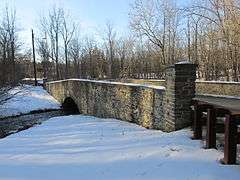
US 9
41°53′39″N 73°54′49″W / 41.894167°N 73.913611°W / 41.894167; -73.913611 (Barringer Farmhouse) |
Rhinebeck |
|
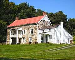
| 3 |
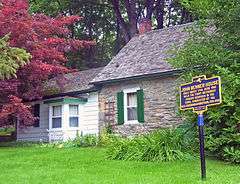
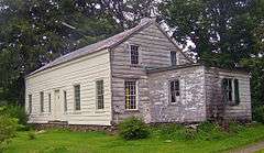
Benner House |
|
000000001987-07-09-0000July 9, 1987
(#87001067) |
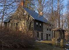
1 Mill St.
41°55′14″N 73°54′36″W / 41.920556°N 73.91°W / 41.920556; -73.91 (Benner House) |
Rhinebeck |
1739 stone house is rare example of Hudson Valley one-room house in German vernacular tradition. It is the Oldest House in Rhinebeck Village.
|
| 4 |
Cox Farmhouse |
Upload image |
000000001987-07-09-0000July 9, 1987
(#87001078) |
Old Post Rd. N
41°56′54″N 73°54′34″W / 41.948333°N 73.909444°W / 41.948333; -73.909444 (Cox Farmhouse) |
Rhinebeck |
|
| 5 |
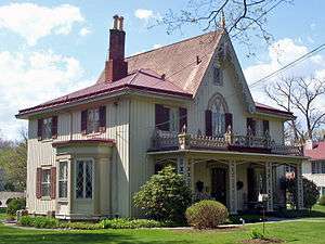
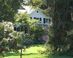
Henry Delamater House |
|
000000001973-05-07-0000May 7, 1973
(#73001185) |
44 Montgomery St.
41°55′42″N 73°54′49″W / 41.928333°N 73.913611°W / 41.928333; -73.913611 (Henry Delamater House) |
Rhinebeck |
Very ornate 1844 Carpenter Gothic house
|
| 6 |
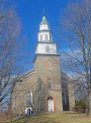
Evangelical Lutheran Church of St. Peter |
|
000000001975-04-24-0000April 24, 1975
(#75001182) |
2.25 mi (3.62 km). N of Rhinebeck on U.S. 9
41°57′45″N 73°53′12″W / 41.9625°N 73.886667°W / 41.9625; -73.886667 (Evangelical Lutheran Church of St. Peter) |
Rhinebeck |
1786 rural stone church built for congregation started in 1730s. Known locally as Old Stone Church.
|
| 7 |
Evergreen Lands |
Upload image |
000000001987-07-09-0000July 9, 1987
(#87001096) |
Delano Dr.
41°53′06″N 73°54′25″W / 41.885°N 73.906944°W / 41.885; -73.906944 (Evergreen Lands) |
Rhinebeck |
|
| 8 |
Fredenburg House |
Upload image |
000000001987-07-09-0000July 9, 1987
(#87001068) |
Old Post Rd.
41°54′04″N 73°54′45″W / 41.901111°N 73.9125°W / 41.901111; -73.9125 (Fredenburg House) |
Rhinebeck |
|
| 9 |
Free Church Parsonage |
Upload image |
000000001987-07-09-0000July 9, 1987
(#87001090) |
Jct. of William and Grinnell Sts.
41°55′03″N 73°57′09″W / 41.9175°N 73.9525°W / 41.9175; -73.9525 (Free Church Parsonage) |
Rhinecliff |
|
| 10 |
Grasmere |
Upload image |
000000001987-07-09-0000July 9, 1987
(#87001093) |
Mill Rd.
41°54′48″N 73°54′43″W / 41.913333°N 73.911944°W / 41.913333; -73.911944 (Grasmere) |
Rhinebeck |
|
| 11 |
The Grove |
Upload image |
000000001987-07-09-0000July 9, 1987
(#87001094) |
Jct. of Miller Rd. and NY 308
41°56′24″N 73°52′40″W / 41.94°N 73.877778°W / 41.94; -73.877778 (The Grove) |
Rhinebeck |
|
| 12 |
Heermance House and Law Office |
|
000000001987-07-09-0000July 9, 1987
(#87001091) |
Jct. of Rhinecliff and Long Dock Rds.
41°55′42″N 73°56′39″W / 41.928333°N 73.944167°W / 41.928333; -73.944167 (Heermance House and Law Office) |
Rhinecliff |
|
| 13 |
Hillside Methodist Church |
|
000000001987-07-09-0000July 9, 1987
(#87001084) |
US 9
41°53′06″N 73°54′42″W / 41.885°N 73.911667°W / 41.885; -73.911667 (Hillside Methodist Church) |
Rhinebeck |
|
| 14 |
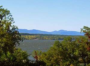
Hudson River Heritage Historic District |
|
000000001990-12-14-0000December 14, 1990
(#90002219) |
E. side Hudson R. between Germantown and Staatsburg
Coordinates missing |
Rhinecliff |
35-square-mile (91 km2) strip of Hudson River shoreline and inland with land use and architecture strongly reflecting quasi-feudal ownership
|
| 15 |
Kip-Beekman-Heermance Site (A027-16-0223) |
|
000000001989-04-19-0000April 19, 1989
(#89000260) |
Address Restricted
|
Rhinecliff |
|
| 16 |
Mansakenning |
Upload image |
000000001987-07-09-0000July 9, 1987
(#87001095) |
Ackert Hook Rd.
41°54′18″N 73°54′00″W / 41.905°N 73.9°W / 41.905; -73.9 (Mansakenning) |
Rhinebeck |
|
| 17 |
The Maples |
|
000000001987-07-09-0000July 9, 1987
(#87001092) |
108 Montgomery St.
41°56′09″N 73°54′57″W / 41.935833°N 73.915833°W / 41.935833; -73.915833 (The Maples) |
Rhinebeck |
1833 Greek Revival house with 1860s Picturesque detailing.
|
| 18 |
J. W. Moore House |
Upload image |
000000001987-07-09-0000July 9, 1987
(#87001085) |
Mill Rd.
41°53′59″N 73°55′37″W / 41.899722°N 73.926944°W / 41.899722; -73.926944 (J. W. Moore House) |
Rhinebeck |
|
| 19 |
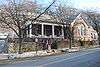
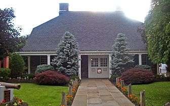
Morton Memorial Library |
|
000000001987-07-09-0000July 9, 1987
(#87001089) |
Kelly St.
41°55′08″N 73°57′06″W / 41.918889°N 73.951667°W / 41.918889; -73.951667 (Morton Memorial Library) |
Rhinecliff |
1905 Colonial Revival house situated on a small knoll along a local street.
|
| 20 |
Neher-Elseffer House |
|
000000002003-04-18-0000April 18, 2003
(#03000246) |
6196 US 9
41°57′32″N 73°53′32″W / 41.958889°N 73.892222°W / 41.958889; -73.892222 (Neher-Elseffer House) |
Rhinebeck |
1746 house is a rare surviving pre-Revolutionary frame house in area. Now owned by town.
|
| 21 |
O'Brien General Store and Post Office |
|
000000001987-07-09-0000July 9, 1987
(#87001088) |
Jct. of Schatzell Ave. and Charles St.
41°55′11″N 73°57′06″W / 41.919722°N 73.951667°W / 41.919722; -73.951667 (O'Brien General Store and Post Office) |
Rhinecliff |
|
| 22 |
Jan Pier House |
Upload image |
000000001987-07-09-0000July 9, 1987
(#87001073) |
NY 308
41°55′43″N 73°53′45″W / 41.92855°N 73.89594°W / 41.92855; -73.89594 (Jan Pier House) |
Rhinebeck |
|
| 23 |
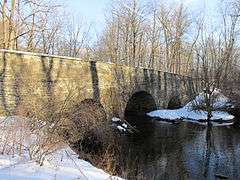
Pilgrim's Progress Road Bridge |
|
000000001987-07-09-0000July 9, 1987
(#87001102) |
Miller Rd. S of NY 308
41°56′22″N 73°52′50″W / 41.939444°N 73.880556°W / 41.939444; -73.880556 (Pilgrim's Progress Road Bridge) |
Rhinebeck |
|
| 24 |
Progue House |
|
000000001987-07-09-0000July 9, 1987
(#87001072) |
Primrose Hill Rd.
41°53′17″N 73°52′53″W / 41.888056°N 73.881389°W / 41.888056; -73.881389 (Progue House) |
Rhinebeck |
|
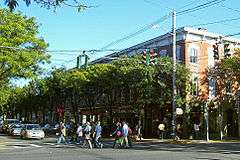
| 25 |
Rhinebeck Village Historic District |
|
000000001979-08-08-0000August 8, 1979
(#79001578) |
U.S. 19 and NY 308
41°55′41″N 73°54′33″W / 41.928056°N 73.909167°W / 41.928056; -73.909167 (Rhinebeck Village Historic District) |
Rhinebeck |
Well-preserved and cohesive collection of historic buildings
|
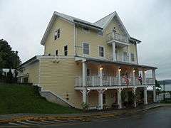
| 26 |
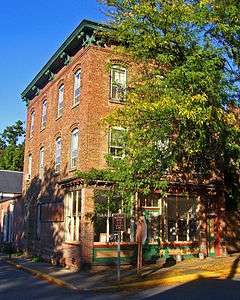
Rhinecliff Hotel |
|
000000001987-07-09-0000July 9, 1987
(#87001087) |
Schatzell Ave.
41°55′11″N 73°57′10″W / 41.919722°N 73.952778°W / 41.919722; -73.952778 (Rhinecliff Hotel) |
Rhinecliff |
|
| 27 |
Riverside Methodist Church and Parsonage |
|
000000001987-07-09-0000July 9, 1987
(#87001086) |
Charles and Orchard Sts.
41°55′12″N 73°57′03″W / 41.92°N 73.950833°W / 41.92; -73.950833 (Riverside Methodist Church and Parsonage) |
Rhinecliff |
|
| 28 |
Rock Ledge |
Upload image |
000000001989-11-28-0000November 28, 1989
(#89002010) |
Roughly Ackert Hook Rd., Haggerty Hill Rd., and Troy Dr.
41°53′41″N 73°53′43″W / 41.894722°N 73.895278°W / 41.894722; -73.895278 (Rock Ledge) |
Rhinebeck |
|
| 29 |
Salisbury Turnpike Bridge |
|
000000001987-07-09-0000July 9, 1987
(#87001100) |
Old Turnpike Rd.
41°56′20″N 73°52′46″W / 41.938889°N 73.879444°W / 41.938889; -73.879444 (Salisbury Turnpike Bridge) |
Rhinebeck |
|
| 30 |
Sipperly Lown Farmhouse |
|
000000001987-07-09-0000July 9, 1987
(#87001101) |
US 9
41°57′57″N 73°53′08″W / 41.965833°N 73.885556°W / 41.965833; -73.885556 (Sipperly Lown Farmhouse) |
Rhinebeck |
19th-century farm complex with Dutch barn and eclectic Victorian 1868 farmhouse
|
| 31 |
Sixteen Mile District |
Upload image |
000000001979-03-07-0000March 7, 1979
(#79001571) |
W of Clermont along Hudson River
41°57′12″N 73°55′29″W / 41.953333°N 73.924722°W / 41.953333; -73.924722 (Sixteen Mile District) |
Rhinebeck |
|
| 32 |
Slate Quarry Road Dutch Barn |
|
000000001987-07-09-0000July 9, 1987
(#87001077) |
Slate Quarry Rd.
41°54′39″N 73°51′32″W / 41.910833°N 73.858889°W / 41.910833; -73.858889 (Slate Quarry Road Dutch Barn) |
Rhinebeck |
|
| 33 |
Steenburg Tavern |
Upload image |
000000001987-07-09-0000July 9, 1987
(#87001070) |
US 9
41°54′36″N 73°54′33″W / 41.91°N 73.909167°W / 41.91; -73.909167 (Steenburg Tavern) |
Rhinebeck |
|
| 34 |
Stonecrest |
Upload image |
000000001987-07-09-0000July 9, 1987
(#87001097) |
Old Post Rd.
41°52′33″N 73°54′49″W / 41.875833°N 73.913611°W / 41.875833; -73.913611 (Stonecrest) |
Rhinebeck |
|
| 35 |
Strawberry Hill |
Upload image |
000000001987-07-09-0000July 9, 1987
(#87001071) |
Ackert Hook Rd.
41°52′58″N 73°53′02″W / 41.882778°N 73.883889°W / 41.882778; -73.883889 (Strawberry Hill) |
Rhinebeck |
Built in 1762. Sold to George Adam Asher by Henry Beekman in 1774. It was later the home of A.D. Rothman.
|
| 36 |
Traver House |
|
000000001987-07-09-0000July 9, 1987
(#87001069) |
Wynkoop Ln.
41°56′30″N 73°53′51″W / 41.941667°N 73.8975°W / 41.941667; -73.8975 (Traver House) |
Rhinebeck |
1730 stone house, built into hillside, expanded in 1790
|
| 37 |
J. E. Traver Farm |
|
000000001987-07-09-0000July 9, 1987
(#87001082) |
Violet Hill Rd.
41°55′34″N 73°52′31″W / 41.926111°N 73.875278°W / 41.926111; -73.875278 (J. E. Traver Farm) |
Rhinebeck |
|
| 38 |
US Post Office-Rhinebeck |
|
000000001989-05-11-0000May 11, 1989
(#88002419) |
6383 Mill St.[5]
41°55′34″N 73°54′49″W / 41.926111°N 73.913611°W / 41.926111; -73.913611 (US Post Office-Rhinebeck) |
Rhinebeck |
Built in imitation of Beekman House under the direction of then-President Franklin D. Roosevelt
|
| 39 |
Van Vredenburg Farm |
Upload image |
000000001987-07-09-0000July 9, 1987
(#87001079) |
Cedar Heights Rd.
41°56′34″N 73°52′46″W / 41.942778°N 73.879444°W / 41.942778; -73.879444 (Van Vredenburg Farm) |
Rhinebeck |
|
| 40 |
Williams Farm |
|
000000001987-07-09-0000July 9, 1987
(#87001080) |
Enterprise Rd.
41°56′09″N 73°50′08″W / 41.935833°N 73.835556°W / 41.935833; -73.835556 (Williams Farm) |
Rhinebeck |
Farm centered around 1835 Greek Revival house |