| [2] |
Name on the Register |
Image |
Date listed[3] |
Location |
City or town |
Description |
|---|
| 1 |
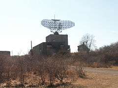
AN/FPS-35 Radar Tower and Antenna |
|
000000002002-06-04-0000June 4, 2002
(#02000615) |
Montauk Point State Parkway
41°03′45″N 71°52′28″W / 41.0625°N 71.874444°W / 41.0625; -71.874444 (AN/FPS-35 Radar Tower and Antenna) |
Montauk |
Only surviving long-range radar station of 12 built by Sperry Corporation in the 1960s
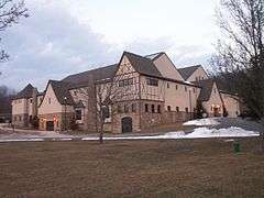
|
| 2 |
Caleb Bragg Estate |
|
000000001987-11-02-0000November 2, 1987
(#87001895) |
Star Island Road
41°04′19″N 71°56′02″W / 41.0719°N 71.9339°W / 41.0719; -71.9339 (Caleb Bragg Estate) |
Montauk |
|
| 3 |
Briar Patch Road Historic District |
|
000000001988-07-21-0000July 21, 1988
(#88001029) |
End of Briar Patch Road along Georgica Pond
40°56′33″N 72°13′41″W / 40.9425°N 72.228056°W / 40.9425; -72.228056 (Briar Patch Road Historic District) |
East Hampton |
|
| 4 |
Buell's Lane Historic District |
|
000000001988-07-21-0000July 21, 1988
(#88001027) |
47-114 Buell's Lane
40°57′33″N 72°11′56″W / 40.959167°N 72.198889°W / 40.959167; -72.198889 (Buell's Lane Historic District) |
East Hampton |
|
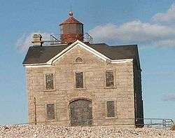
| 5 |
Cedar Island Lighthouse |
|
000000002003-04-18-0000April 18, 2003
(#03000248) |
Cedar Point Road
41°02′26″N 72°15′39″W / 41.040556°N 72.260833°W / 41.040556; -72.260833 (Cedar Island Lighthouse) |
Northwest Harbor |
|
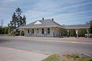
| 6 |
East Hampton Railroad Station |
|
000000002000-06-02-0000June 2, 2000
(#00000581) |
Railroad Avenue, between Race and Newtown Lanes
40°58′00″N 72°11′36″W / 40.966667°N 72.193333°W / 40.966667; -72.193333 (East Hampton Railroad Station) |
East Hampton |
|
| 7 |
East Hampton Village District |
|
000000001974-05-02-0000May 2, 1974
(#74001309) |
Bounded by Main Street and James and Woods Lanes
40°57′17″N 72°11′28″W / 40.954722°N 72.191111°W / 40.954722; -72.191111 (East Hampton Village District) |
East Hampton |
|
| 8 |
Egypt Lane Historic District |
|
000000001988-07-21-0000July 21, 1988
(#88001031) |
111, 117, and 129 Egypt Lane
40°57′30″N 72°10′39″W / 40.958333°N 72.1775°W / 40.958333; -72.1775 (Egypt Lane Historic District) |
East Hampton |
|
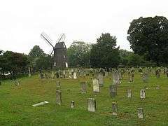
| 9 |
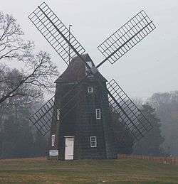
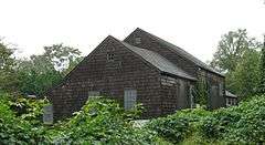
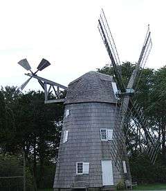
Gardiners Island Windmill |
|
000000001978-12-27-0000December 27, 1978
(#78001912) |
On Gardiners Island
41°05′28″N 72°06′40″W / 41.091111°N 72.111111°W / 41.091111; -72.111111 (Gardiners Island Windmill) |
Gardiners Island |
|
| 10 |
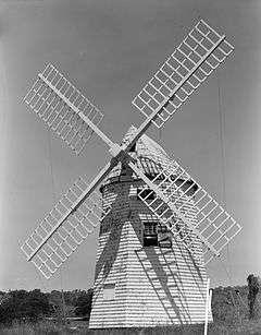
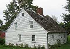
Hayground Windmill |
|
000000001978-12-27-0000December 27, 1978
(#78001913) |
At Windmill Lane
40°57′17″N 72°09′57″W / 40.954722°N 72.165833°W / 40.954722; -72.165833 (Hayground Windmill) |
East Hampton |
|
| 11 |
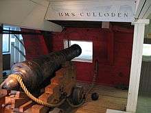
H.M.S. CULLODEN Shipwreck Site |
|
000000001979-03-05-0000March 5, 1979
(#79003795) |
Culloden Point
41°04′13″N 71°57′36″W / 41.070278°N 71.96°W / 41.070278; -71.96 (H.M.S. CULLODEN Shipwreck Site) |
Montauk |
|
| 12 |
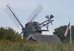
Hook Windmill |
|
000000001978-12-27-0000December 27, 1978
(#78001914) |
North Main Street
40°57′56″N 72°11′02″W / 40.965556°N 72.183889°W / 40.965556; -72.183889 (Hook Windmill) |
East Hampton |
|
| 13 |
Jericho Historic District |
|
000000001988-07-21-0000July 21, 1988
(#88001028) |
Montauk Highway
40°57′04″N 72°13′00″W / 40.951111°N 72.216667°W / 40.951111; -72.216667 (Jericho Historic District) |
East Hampton |
|
| 14 |
Jones Road Historic District |
|
000000001988-07-21-0000July 21, 1988
(#88001030) |
Along Jones Road from Apaquogue Road to Lily Pond Lane
40°56′31″N 72°12′42″W / 40.941944°N 72.211667°W / 40.941944; -72.211667 (Jones Road Historic District) |
East Hampton |
|
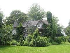
| 15 |
Miss Amelia's Cottage |
|
000000001994-02-25-0000February 25, 1994
(#94000070) |
N side Main Street, at the jct. of Windmill Lane, Town of East Hampton
40°58′26″N 72°08′39″W / 40.973889°N 72.144167°W / 40.973889; -72.144167 (Miss Amelia's Cottage) |
Amagansett |
|
| 16 |
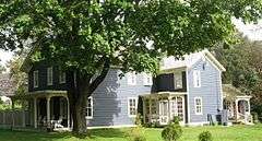
Montauk Association Historic District |
|
000000001976-10-22-0000October 22, 1976
(#76001282) |
E of Montauk off NY 27 on DeForest Road
41°02′38″N 71°54′24″W / 41.043889°N 71.906667°W / 41.043889; -71.906667 (Montauk Association Historic District) |
Montauk |
Seven Shingle style houses nestle by the seashore.
|
| 17 |
Montauk Manor |
|
000000001984-08-23-0000August 23, 1984
(#84002995) |
Fairmont Avenue
41°02′54″N 71°56′59″W / 41.048333°N 71.949722°W / 41.048333; -71.949722 (Montauk Manor) |
Montauk |
|
| 18 |
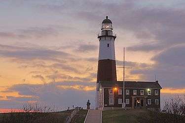
Montauk Point Light |
|
000000001969-07-07-0000July 7, 1969
(#69000142) |
Montauk Point, 2000 Montauk Hwy.
41°04′15″N 71°51′25″W / 41.070833°N 71.856944°W / 41.070833; -71.856944 (Montauk Point Light) |
Montauk |
designated a National Historic Landmark 000000002012-03-02-0000March 2, 2012
|
| 19 |
Montauk Tennis Auditorium |
|
000000001988-02-08-0000February 8, 1988
(#88000052) |
Flamingon Avenue and Edgemere Street
41°03′01″N 71°57′04″W / 41.050278°N 71.951111°W / 41.050278; -71.951111 (Montauk Tennis Auditorium) |
Montauk |
|
| 20 |
Thomas Moran House |
|
000000001966-10-15-0000October 15, 1966
(#66000574) |
Main Street
40°57′14″N 72°11′40″W / 40.953889°N 72.194444°W / 40.953889; -72.194444 (Thomas Moran House) |
East Hampton |
|
| 21 |
North Main Street Historic District |
|
000000001988-07-21-0000July 21, 1988
(#88001025) |
North Main Street
40°57′55″N 72°11′03″W / 40.965278°N 72.184167°W / 40.965278; -72.184167 (North Main Street Historic District) |
East Hampton |
|
| 22 |
Pantigo Road Historic District |
|
000000001988-07-21-0000July 21, 1988
(#88001026) |
Along Pantigo Road from Egypt Lane and Accabonac Road to Amy's Lane
40°57′59″N 72°10′40″W / 40.966389°N 72.177778°W / 40.966389; -72.177778 (Pantigo Road Historic District) |
East Hampton |
|
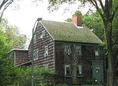
| 23 |
Ambrose Parsons House |
|
000000001995-11-07-0000November 7, 1995
(#95001276) |
Springs-Fireplace Road at jct. with Old Stone Highway, Town of East Hampton
41°01′14″N 72°09′26″W / 41.020556°N 72.157222°W / 41.020556; -72.157222 (Ambrose Parsons House) |
Springs |
|
| 24 |
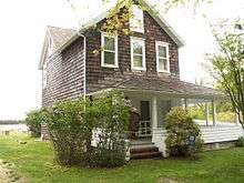
Pleasants House |
|
000000001984-02-02-0000February 2, 1984
(#84002999) |
NY 27
40°58′32″N 72°08′23″W / 40.975556°N 72.139722°W / 40.975556; -72.139722 (Pleasants House) |
Amagansett |
|
| 25 |
Jackson Pollock House and Studio |
|
000000001994-04-19-0000April 19, 1994
(#94001193) |
830 Fireplace Road
41°01′25″N 72°09′19″W / 41.023611°N 72.155278°W / 41.023611; -72.155278 (Jackson Pollock House and Studio) |
Springs |
|
| 26 |
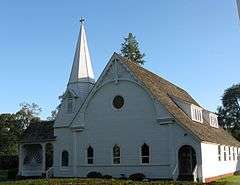
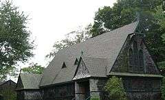
Saint Thomas' Chapel |
|
000000001997-02-14-0000February 14, 1997
(#97000065) |
Main Street, jct. with Indian Wells Plain Highway
40°58′23″N 72°08′39″W / 40.973056°N 72.144167°W / 40.973056; -72.144167 (Saint Thomas' Chapel) |
Amagansett |
|
| 27 |
Stephen Sherrill House |
|
000000001996-01-04-0000January 4, 1996
(#95001486) |
4 Fireplace Road
40°58′22″N 72°10′53″W / 40.972778°N 72.181389°W / 40.972778; -72.181389 (Stephen Sherrill House) |
East Hampton |
|
| 28 |
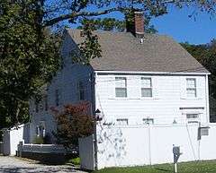
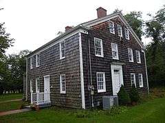
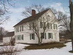
Thomas Strong House |
|
000000002005-01-05-0000January 5, 2005
(#04001451) |
100 Wainscott Hollow Road
40°56′12″N 72°15′08″W / 40.936667°N 72.252222°W / 40.936667; -72.252222 (Thomas Strong House) |
Wainscott |
|
| 29 |
Wainscott Windmill |
|
000000001978-12-27-0000December 27, 1978
(#78001915) |
On Georgica Association grounds
40°56′01″N 72°14′16″W / 40.933611°N 72.237778°W / 40.933611; -72.237778 (Wainscott Windmill) |
Wainscott |
|