| [2] |
Name on the Register |
Image |
Date listed[3] |
Location |
City or town |
Description |
|---|
| 1 |
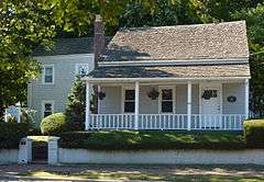
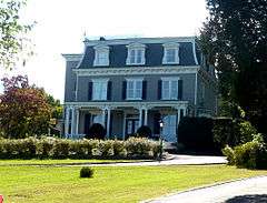
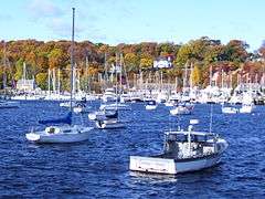
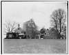
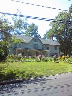
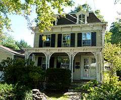
Bay Crest Historic District |
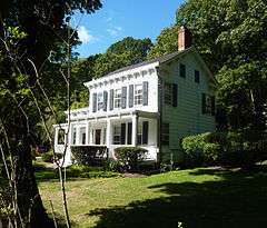
|
000000001985-09-26-0000September 26, 1985
(#85002486) |
Beech Avenue, Valley Road, and Woodside and Valley Drives
40°54′02″N 73°25′04″W / 40.900556°N 73.417778°W / 40.900556; -73.417778 (Bay Crest Historic District) |
Huntington Bay |
|
| 2 |
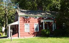
M. Baylis House |
Upload image |
000000001985-09-26-0000September 26, 1985
(#85002487) |
530 Sweet Hollow Road
40°47′24″N 73°25′02″W / 40.79°N 73.417222°W / 40.79; -73.417222 (M. Baylis House) |
Melville |
|
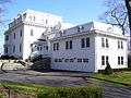
| 3 |
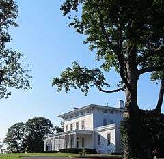
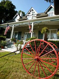
Beaux Arts Park Historic District |
|
000000001985-09-26-0000September 26, 1985
(#85002489) |
Locust Lane, Upper & Lower Drives
40°54′02″N 73°24′31″W / 40.900556°N 73.408611°W / 40.900556; -73.408611 (Beaux Arts Park Historic District) |
Huntington Bay |
|
| 4 |
Bethel AME Church and Manse |
|
000000001985-09-26-0000September 26, 1985
(#85002490) |
291 Park Avenue
40°52′41″N 73°25′07″W / 40.878056°N 73.418611°W / 40.878056; -73.418611 (Bethel AME Church and Manse) |
Huntington |
|
| 5 |
Bowes House |
Upload image |
000000001985-09-26-0000September 26, 1985
(#85002492) |
15 Harbor Hill Drive
40°54′02″N 73°25′28″W / 40.900556°N 73.424444°W / 40.900556; -73.424444 (Bowes House) |
Huntington Bay |
|
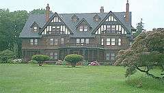
| 6 |
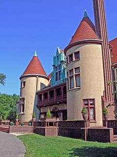
George McKesson Brown Estate-Coindre Hall |
|
000000001985-09-26-0000September 26, 1985
(#85002493) |
Brown's Road
40°53′41″N 73°26′13″W / 40.894722°N 73.436944°W / 40.894722; -73.436944 (George McKesson Brown Estate-Coindre Hall) |
Huntington |
|
| 7 |
Eliphas Buffett House |
|
000000001985-09-26-0000September 26, 1985
(#85002495) |
159 West Rogues Path
40°50′16″N 73°26′38″W / 40.837778°N 73.443889°W / 40.837778; -73.443889 (Eliphas Buffett House) |
Cold Spring Harbor |
|
| 8 |
Joseph Buffett House |
|
000000001985-09-26-0000September 26, 1985
(#85002497) |
169 West Rogues Path
40°50′16″N 73°26′43″W / 40.837778°N 73.445278°W / 40.837778; -73.445278 (Joseph Buffett House) |
Cold Spring Harbor |
|
| 9 |
John Bumpstead House |
Upload image |
000000001985-09-26-0000September 26, 1985
(#85002499) |
473 Woodbury Road
40°50′44″N 73°27′02″W / 40.845556°N 73.450556°W / 40.845556; -73.450556 (John Bumpstead House) |
Cold Spring Harbor |
|
| 10 |
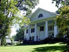
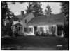
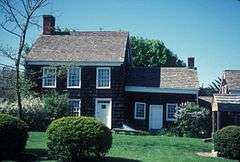
Carll S. Burr Mansion |
|
000000001985-09-26-0000September 26, 1985
(#85002502) |
304 Burr Road
40°51′04″N 73°17′47″W / 40.851111°N 73.296389°W / 40.851111; -73.296389 (Carll S. Burr Mansion) |
Commack |
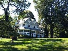
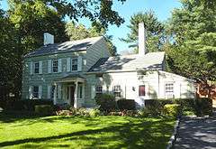
A historic Second Empire mansion built in 1830 in Commack, New York by Carll S. Burr
|
| 11 |
Carll Burr, Jr., House |
Upload image |
000000001985-09-26-0000September 26, 1985
(#85002503) |
293 Burr Road
40°51′04″N 73°18′06″W / 40.851111°N 73.301667°W / 40.851111; -73.301667 (Carll Burr, Jr., House) |
Commack |
|
| 12 |
Carll House |
Upload image |
000000001985-09-26-0000September 26, 1985
(#85002505) |
380 Deer Park Road
40°48′43″N 73°20′30″W / 40.811944°N 73.341667°W / 40.811944; -73.341667 (Carll House) |
Dix Hills |
|
| 13 |
Carll House |
|
000000001985-09-26-0000September 26, 1985
(#85002504) |
79 Wall Street
40°52′22″N 73°25′43″W / 40.872778°N 73.428611°W / 40.872778; -73.428611 (Carll House) |
Huntington |
|
| 14 |
Ezra Carll Homestead |
|
000000001985-09-26-0000September 26, 1985
(#85002506) |
49 Melville Road
40°49′40″N 73°23′48″W / 40.827778°N 73.396667°W / 40.827778; -73.396667 (Ezra Carll Homestead) |
South Huntington |
|
| 15 |
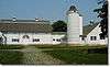
Marion Carll Farm |
|
000000001979-06-26-0000June 26, 1979
(#79001632) |
475 Commack Road
40°49′33″N 73°17′44″W / 40.825833°N 73.295556°W / 40.825833; -73.295556 (Marion Carll Farm) |
Commack |
|
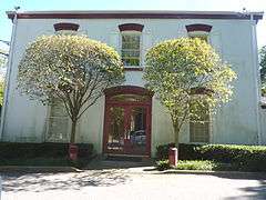
| 16 |
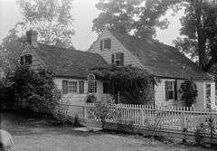
Chichester's Inn |
|
000000001985-09-26-0000September 26, 1985
(#85002508) |
97 Chichester Road
40°49′11″N 73°25′31″W / 40.819722°N 73.425278°W / 40.819722; -73.425278 (Chichester's Inn) |
West Hills |
17th-century inn frequented by Walt Whitman and Theodore Roosevelt at different times. A house today.
|
| 17 |
Cold Spring Harbor Beach Club |
|
000000002012-12-12-0000December 12, 2012
(#12001037) |
101 Shore Rd.
40°52′34″N 73°28′10″W / 40.876109°N 73.469505°W / 40.876109; -73.469505 (Cold Spring Harbor Beach Club) |
Cold Spring Harbor |
Official site
|
| 18 |
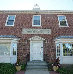
Cold Spring Harbor Fire District Hook and Ladder Company Building |
|
000000002003-11-15-0000November 15, 2003
(#03001147) |
Main Street at Elm Place
40°52′10″N 73°27′39″W / 40.869444°N 73.460833°W / 40.869444; -73.460833 (Cold Spring Harbor Fire District Hook and Ladder Company Building) |
Cold Spring Harbor |
|
| 19 |
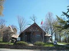
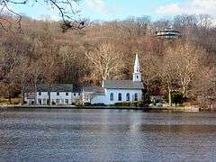
Cold Spring Harbor Library |
|
000000001985-09-26-0000September 26, 1985
(#85002509) |
1 Shore Road
40°52′20″N 73°27′40″W / 40.872222°N 73.461111°W / 40.872222; -73.461111 (Cold Spring Harbor Library) |
Cold Spring Harbor |
|
| 20 |
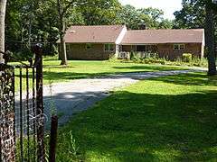
Coltrane House |
|
000000002007-06-29-0000June 29, 2007
(#07000628) |
247 Candlewood Path
40°47′59″N 73°19′27″W / 40.799803°N 73.324286°W / 40.799803; -73.324286 (Coltrane House) |
Dix Hills |
|
| 21 |
Commack Methodist Church and Cemetery |
|
000000001985-09-26-0000September 26, 1985
(#85002511) |
486 Townline Road
40°50′41″N 73°17′36″W / 40.844722°N 73.293333°W / 40.844722; -73.293333 (Commack Methodist Church and Cemetery) |
Commack |
|
| 22 |
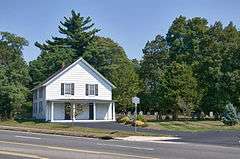
David Conklin House |
|
000000001985-09-26-0000September 26, 1985
(#85002513) |
2 High Street
40°51′55″N 73°25′26″W / 40.865278°N 73.423889°W / 40.865278; -73.423889 (David Conklin House) |
Huntington |
|
| 23 |
The Crest |
Upload image |
000000002007-10-03-0000October 3, 2007
(#85003645) |
563 Asharoken Avenue
40°56′22″N 73°23′09″W / 40.939444°N 73.385833°W / 40.939444; -73.385833 (The Crest) |
Asharoken |
|
| 24 |
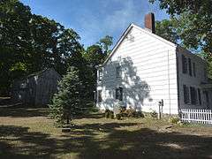
Charles Homer Davis House |
|
000000002006-02-22-0000February 22, 2006
(#06000057) |
381 West Neck Road
40°53′37″N 73°27′18″W / 40.893611°N 73.455°W / 40.893611; -73.455 (Charles Homer Davis House) |
Lloyd Harbor |
|
| 25 |
Delamater-Bevin Mansion |
|
000000001985-09-26-0000September 26, 1985
(#85002514) |
Bevin Lane
40°56′05″N 73°22′43″W / 40.934722°N 73.378611°W / 40.934722; -73.378611 (Delamater-Bevin Mansion) |
Asharoken |
|
| 26 |
Harry E. Donnell House |
|
000000001985-09-26-0000September 26, 1985
(#85002516) |
71 Locust Lane
40°56′02″N 73°23′21″W / 40.933889°N 73.389167°W / 40.933889; -73.389167 (Harry E. Donnell House) |
Eatons Neck |
|
| 27 |
Arthur Dove-Helen Torr Cottage |
Upload image |
000000002000-01-28-0000January 28, 2000
(#99001682) |
30 Centershore Road
40°53′16″N 73°22′21″W / 40.887778°N 73.3725°W / 40.887778; -73.3725 (Arthur Dove-Helen Torr Cottage) |
Centerport |
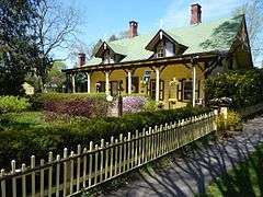
|
| 28 |
Dowden Tannery |
|
000000001985-09-26-0000September 26, 1985
(#85002519) |
210 West Rogues Path
40°50′16″N 73°26′58″W / 40.837778°N 73.449444°W / 40.837778; -73.449444 (Dowden Tannery) |
Cold Spring Harbor |
|
| 29 |
East Shore Road Historic District |
|
000000001985-09-26-0000September 26, 1985
(#85002521) |
East Shore Road
40°53′27″N 73°25′00″W / 40.890833°N 73.416667°W / 40.890833; -73.416667 (East Shore Road Historic District) |
Halesite |
|
| 30 |
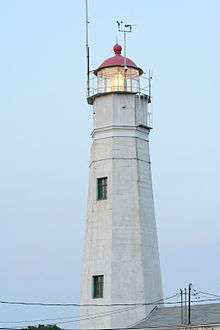
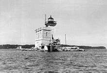
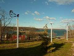
Eatons Neck Light |
|
000000001973-04-03-0000April 3, 1973
(#73001273) |
Eatons Neck Point at Huntington Bay and Long Island Sound off Lighthouse Road
40°57′15″N 73°23′48″W / 40.954167°N 73.396667°W / 40.954167; -73.396667 (Eatons Neck Light) |
Asharoken |
|
| 31 |
John Everit House |
Upload image |
000000001985-09-26-0000September 26, 1985
(#85002522) |
130 Old Country Road
40°47′33″N 73°25′18″W / 40.7925°N 73.421667°W / 40.7925; -73.421667 (John Everit House) |
West Hills |
|
| 32 |
N. J. Felix House |
Upload image |
000000001985-09-26-0000September 26, 1985
(#85002523) |
235 Asharoken Avenue
40°55′41″N 73°21′47″W / 40.928128°N 73.363031°W / 40.928128; -73.363031 (N. J. Felix House) |
Asharoken |
|
| 33 |
Marshall Field, III, Estate |
|
000000001979-04-30-0000April 30, 1979
(#79001633) |
Lloyd Harbor Road
40°55′39″N 73°28′18″W / 40.9275°N 73.471667°W / 40.9275; -73.471667 (Marshall Field, III, Estate) |
Lloyd Harbor |
|
| 34 |
Fort Golgotha and the Old Burial Hill Cemetery |
|
000000001981-03-02-0000March 2, 1981
(#81000415) |
Main Street and Nassau Road
40°52′17″N 73°25′26″W / 40.871389°N 73.423889°W / 40.871389; -73.423889 (Fort Golgotha and the Old Burial Hill Cemetery) |
Huntington |
|
| 35 |
Fort Hill Estate |
|
000000001988-06-02-0000June 2, 1988
(#88000599) |
Fort Hill Drive
40°55′04″N 73°29′19″W / 40.917778°N 73.488611°W / 40.917778; -73.488611 (Fort Hill Estate) |
Lloyd Harbor |
|
| 36 |
Charles Geoghegan House |
Upload image |
000000001985-09-26-0000September 26, 1985
(#85002524) |
9 Harbor Hill Drive
40°54′07″N 73°25′23″W / 40.901944°N 73.423056°W / 40.901944; -73.423056 (Charles Geoghegan House) |
Huntington Bay |
|
| 37 |
Gilsey Mansion |
|
000000001985-09-26-0000September 26, 1985
(#85002525) |
36 Browns Road
40°53′39″N 73°26′07″W / 40.894167°N 73.435278°W / 40.894167; -73.435278 (Gilsey Mansion) |
Huntington |
|
| 38 |
Goose Hill Road Historic District |
Upload image |
000000001985-09-26-0000September 26, 1985
(#85002528) |
Goose Hill Road
40°52′40″N 73°27′06″W / 40.877778°N 73.451667°W / 40.877778; -73.451667 (Goose Hill Road Historic District) |
Cold Spring Harbor |
|
| 39 |
John Green House |
Upload image |
000000001985-09-26-0000September 26, 1985
(#85002526) |
167 East Shore Road
40°53′54″N 73°25′33″W / 40.898333°N 73.425833°W / 40.898333; -73.425833 (John Green House) |
Huntington Bay |
|
| 40 |
Halsey Estate-Tallwood |
Upload image |
000000001985-09-26-0000September 26, 1985
(#85002527) |
Sweet Hollow Road
40°49′32″N 73°25′53″W / 40.825556°N 73.431389°W / 40.825556; -73.431389 (Halsey Estate-Tallwood) |
West Hills |
|
| 41 |
Harbor Road Historic District |
|
000000001985-09-26-0000September 26, 1985
(#85002529) |
Harbor Road
40°51′34″N 73°27′43″W / 40.859444°N 73.461944°W / 40.859444; -73.461944 (Harbor Road Historic District) |
Cold Spring Harbor |
|
| 42 |
John Harned House |
Upload image |
000000001985-09-26-0000September 26, 1985
(#85002530) |
26 Little Neck Road
40°53′16″N 73°21′55″W / 40.887778°N 73.365278°W / 40.887778; -73.365278 (John Harned House) |
Centerport |
|
| 43 |
Wallace K. Harrison Estate |
Upload image |
000000001985-09-26-0000September 26, 1985
(#85002531) |
140 Round Swamp Road
40°48′28″N 73°26′30″W / 40.807778°N 73.441667°W / 40.807778; -73.441667 (Wallace K. Harrison Estate) |
West Hills |
|
| 44 |
Heckscher Park |
|
000000001985-09-26-0000September 26, 1985
(#85002532) |
Bounded by Madison Street, Sabbath Day Path, Main Street & Prime Avenue
40°52′30″N 73°25′36″W / 40.875°N 73.426667°W / 40.875; -73.426667 (Heckscher Park) |
Huntington |
|
| 45 |
Hewlett House |
Upload image |
000000001985-09-26-0000September 26, 1985
(#85002533) |
559 Woodbury Road
40°50′13″N 73°27′12″W / 40.836944°N 73.453333°W / 40.836944; -73.453333 (Hewlett House) |
Cold Spring Harbor |
|
| 46 |
House at 200 Bay Avenue |
Upload image |
000000001985-09-26-0000September 26, 1985
(#85002535) |
200 Bay Avenue
40°54′00″N 73°25′11″W / 40.9°N 73.419722°W / 40.9; -73.419722 (House at 200 Bay Avenue) |
Huntington Bay |
|
| 47 |
House at 244 Park Avenue |
Upload image |
000000001985-09-26-0000September 26, 1985
(#85002534) |
244 Park Avenue
40°52′47″N 73°25′05″W / 40.879722°N 73.418056°W / 40.879722; -73.418056 (House at 244 Park Avenue) |
Huntington |
|
| 48 |
Ireland-Gardiner Farm |
Upload image |
000000001985-09-26-0000September 26, 1985
(#85002537) |
863 Lake Road
40°51′46″N 73°22′56″W / 40.862778°N 73.382222°W / 40.862778; -73.382222 (Ireland-Gardiner Farm) |
Greenlawn |
|
| 49 |
Jarvis-Fleet House |
|
000000001985-09-26-0000September 26, 1985
(#85002538) |
138 Cove Road
40°53′58″N 73°23′31″W / 40.899444°N 73.391944°W / 40.899444; -73.391944 (Jarvis-Fleet House) |
Huntington |
|
| 50 |
John P. Kane Mansion |
|
000000001985-09-26-0000September 26, 1985
(#85002580) |
37 Kanes Lane
40°53′54″N 73°25′15″W / 40.898333°N 73.420833°W / 40.898333; -73.420833 (John P. Kane Mansion) |
Huntington Bay |
|
| 51 |
Karpen House |
Upload image |
000000002006-07-26-0000July 26, 2006
(#06000643) |
3 Harbor Hill Drive
40°53′46″N 73°27′17″W / 40.896111°N 73.454722°W / 40.896111; -73.454722 (Karpen House) |
Lloyd Harbor |
|
| 52 |
A. P. W. Kennan House |
|
000000001985-11-06-0000November 6, 1985
(#85003502) |
Sydney Road
40°54′10″N 73°24′40″W / 40.902778°N 73.411111°W / 40.902778; -73.411111 (A. P. W. Kennan House) |
Huntington Bay |
|
| 53 |
B. Ketchum House |
Upload image |
000000001985-09-26-0000September 26, 1985
(#85002581) |
237 Middleville Road
40°53′57″N 73°17′51″W / 40.899167°N 73.2975°W / 40.899167; -73.2975 (B. Ketchum House) |
Fort Salonga |
|
| 54 |
LITTLE JENNIE (Chesapeake Bay bugeye) |
Upload image |
000000001986-05-12-0000May 12, 1986
(#86001081) |
Centerport Harbor
40°53′36″N 73°22′28″W / 40.893333°N 73.374444°W / 40.893333; -73.374444 (LITTLE JENNIE (Chesapeake Bay bugeye)) |
Centerport |
|
| 55 |
Lloyd Harbor Lighthouse |
|
000000001989-05-31-0000May 31, 1989
(#89000501) |
Entrance to Lloyd Harbor
40°54′39″N 73°25′54″W / 40.910833°N 73.431667°W / 40.910833; -73.431667 (Lloyd Harbor Lighthouse) |
Lloyd Harbor |
|
| 56 |
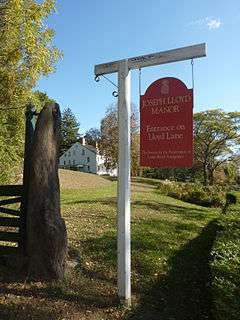
Joseph Lloyd House |
|
000000001976-11-07-0000November 7, 1976
(#76001278) |
Northwest of Huntington on Lloyd Harbor Road
40°54′51″N 73°28′42″W / 40.914167°N 73.478333°W / 40.914167; -73.478333 (Joseph Lloyd House) |
Lloyd Harbor |
|
| 57 |
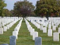
Long Island National Cemetery |
|
000000002016-03-22-0000March 22, 2016
(#16000113) |
2040 Wellwood Ave.
40°45′27″N 73°23′48″W / 40.75750°N 73.39667°W / 40.75750; -73.39667 (Long Island National Cemetery) |
Melville |
Veterans' cemetery shared with town of Babylon to south built in 1930s to handle overflow from Cypress Hills soon expanded to take in 10,000 World War II veterans and POWs.
|
| 58 |
Isaac Losee House |
|
000000001985-09-26-0000September 26, 1985
(#85002582) |
269 Park Avenue
40°52′44″N 73°25′07″W / 40.878889°N 73.418611°W / 40.878889; -73.418611 (Isaac Losee House) |
Huntington |
|
| 59 |
Main Street Historic District |
|
000000001985-09-26-0000September 26, 1985
(#85002583) |
Main Street
40°52′18″N 73°27′21″W / 40.871667°N 73.455833°W / 40.871667; -73.455833 (Main Street Historic District) |
Cold Spring Harbor |
|
| 60 |
Northport Public Library |
|
000000001996-12-06-0000December 6, 1996
(#96001429) |
215 Main Street
40°54′05″N 73°20′38″W / 40.901389°N 73.343889°W / 40.901389; -73.343889 (Northport Public Library) |
Northport |
|
| 61 |
Northport Veterans Administration Hospital Historic District |
|
000000002012-05-24-0000May 24, 2012
(#12000312) |
79 Middleville Rd.
40°53′52″N 73°18′48″W / 40.897863°N 73.313273°W / 40.897863; -73.313273 (Northport Veterans Administration Hospital Historic District) |
East Northport |
part of the United States Second Generation Veterans Hospitals Multiple Property Submission
|
| 62 |
C. A. O'Donohue House |
Upload image |
000000001985-09-26-0000September 26, 1985
(#85002584) |
158 Shore Road
40°53′59″N 73°25′26″W / 40.899722°N 73.423889°W / 40.899722; -73.423889 (C. A. O'Donohue House) |
Huntington Bay |
|
| 63 |
John Oakley House |
Upload image |
000000001985-11-06-0000November 6, 1985
(#85003501) |
Sweet Hollow Road
40°49′14″N 73°25′31″W / 40.820556°N 73.425278°W / 40.820556; -73.425278 (John Oakley House) |
West Hills |
|
| 64 |
Oheka |
|
000000002004-09-15-0000September 15, 2004
(#04000996) |
135 West Gate Drive
40°49′40″N 73°26′55″W / 40.827778°N 73.448611°W / 40.827778; -73.448611 (Oheka) |
Cold Springs Hills |
|
| 65 |
Old First Church |
|
000000001985-11-06-0000November 6, 1985
(#85003500) |
126 Main Street
40°52′28″N 73°25′11″W / 40.874444°N 73.419722°W / 40.874444; -73.419722 (Old First Church) |
Huntington |
|
| 66 |
Old Town Green Historic District |
|
000000001985-09-26-0000September 26, 1985
(#85002586) |
Park Avenue
40°52′29″N 73°24′52″W / 40.874722°N 73.414444°W / 40.874722; -73.414444 (Old Town Green Historic District) |
Huntington |
|
| 67 |
Old Town Hall Historic District |
|
000000001985-09-26-0000September 26, 1985
(#85002588) |
Main Street & Nassau Road
40°52′17″N 73°25′26″W / 40.871389°N 73.423889°W / 40.871389; -73.423889 (Old Town Hall Historic District) |
Huntington |
|
| 68 |
Potter-Williams House |
Upload image |
000000001985-09-26-0000September 26, 1985
(#85002579) |
165 Wall Street
40°52′37″N 73°26′18″W / 40.876944°N 73.438333°W / 40.876944; -73.438333 (Potter-Williams House) |
Huntington |
|
| 69 |
Prime House |
|
000000001985-09-26-0000September 26, 1985
(#85002568) |
35 Prime Avenue
40°52′26″N 73°25′23″W / 40.873889°N 73.423056°W / 40.873889; -73.423056 (Prime House) |
Huntington |
|
| 70 |
Prime-Octagon House |
|
000000001985-09-26-0000September 26, 1985
(#85002569) |
41 Prime Avenue
40°52′28″N 73°25′23″W / 40.874444°N 73.423056°W / 40.874444; -73.423056 (Prime-Octagon House) |
Huntington |
|
| 71 |
Michael Remp House |
Upload image |
000000001985-09-26-0000September 26, 1985
(#85002570) |
42 Godfrey Lane
40°50′48″N 73°21′15″W / 40.846667°N 73.354167°W / 40.846667; -73.354167 (Michael Remp House) |
Greenlawn |
|
| 72 |
Rogers House |
|
000000001985-09-26-0000September 26, 1985
(#85002571) |
136 Spring Road
40°51′57″N 73°24′56″W / 40.865833°N 73.415556°W / 40.865833; -73.415556 (Rogers House) |
Huntington |
|
| 73 |
John Rogers House |
Upload image |
000000001985-09-26-0000September 26, 1985
(#85002572) |
627 Half Hollow Road
40°47′18″N 73°20′50″W / 40.788333°N 73.347222°W / 40.788333; -73.347222 (John Rogers House) |
Dix Hills |
|
| 74 |
Silas Sammis House |
|
000000001985-09-26-0000September 26, 1985
(#85002573) |
302 West Neck Road
40°53′09″N 73°26′23″W / 40.885833°N 73.439722°W / 40.885833; -73.439722 (Silas Sammis House) |
Huntington |
|
| 75 |
Seaman Farm |
Upload image |
000000001985-09-26-0000September 26, 1985
(#85002575) |
1378 Carlls Straight Path
40°48′37″N 73°19′11″W / 40.810278°N 73.319722°W / 40.810278; -73.319722 (Seaman Farm) |
Dix Hills |
Demolished in 1995[4]
|
| 76 |
Shore Road Historic District |
|
000000001985-09-26-0000September 26, 1985
(#85002578) |
Shore Road
40°52′22″N 73°27′45″W / 40.872778°N 73.4625°W / 40.872778; -73.4625 (Shore Road Historic District) |
Cold Spring Harbor |
|
| 77 |
Daniel Smith House |
Upload image |
000000001985-09-26-0000September 26, 1985
(#85002576) |
117 West Shore Road
40°53′13″N 73°25′31″W / 40.886944°N 73.425278°W / 40.886944; -73.425278 (Daniel Smith House) |
Huntington |
|
| 78 |
Henry Smith Farmstead |
Upload image |
000000001985-09-26-0000September 26, 1985
(#85002539) |
900 Park Avenue
40°51′03″N 73°22′48″W / 40.850833°N 73.38°W / 40.850833; -73.38 (Henry Smith Farmstead) |
Huntington Station |
|
| 79 |
Jacob Smith House |
Upload image |
000000001985-09-26-0000September 26, 1985
(#85002540) |
High Hold Drive
40°48′46″N 73°26′16″W / 40.812778°N 73.437778°W / 40.812778; -73.437778 (Jacob Smith House) |
West Hills |
|
| 80 |
Suydam House |
|
000000001988-10-27-0000October 27, 1988
(#88002135) |
1 Fort Salonga Road
40°53′09″N 73°22′01″W / 40.885833°N 73.366944°W / 40.885833; -73.366944 (Suydam House) |
Centerport |
|
| 81 |
Sweet Hollow Presbyterian Church Parsonage |
Upload image |
000000001985-09-26-0000September 26, 1985
(#85002541) |
152 Old Country Road
40°47′33″N 73°25′05″W / 40.7925°N 73.418056°W / 40.7925; -73.418056 (Sweet Hollow Presbyterian Church Parsonage) |
Melville |
|
| 82 |
Titus-Bunce House |
|
000000001985-09-26-0000September 26, 1985
(#85002542) |
7 Goose Hill Road
40°52′27″N 73°27′06″W / 40.874167°N 73.451667°W / 40.874167; -73.451667 (Titus-Bunce House) |
Cold Spring Harbor |
|
| 83 |
Henry Townsend House |
|
000000001985-09-26-0000September 26, 1985
(#85002543) |
231 West Neck Road
40°55′33″N 73°26′12″W / 40.925833°N 73.436667°W / 40.925833; -73.436667 (Henry Townsend House) |
Huntington |
|
| 84 |
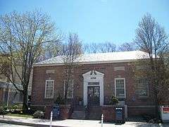
US Post Office-Northport |
|
000000001989-05-11-0000May 11, 1989
(#88002356) |
244 Main Street
40°54′02″N 73°20′52″W / 40.900556°N 73.347778°W / 40.900556; -73.347778 (US Post Office-Northport) |
Northport |
|
| 85 |
Charles Van Iderstine Mansion |
Upload image |
000000001985-09-26-0000September 26, 1985
(#85002544) |
Idle Day Drive
40°54′13″N 73°21′48″W / 40.903611°N 73.363333°W / 40.903611; -73.363333 (Charles Van Iderstine Mansion) |
Centerport |
|
| 86 |
Van Wyck-Lefferts Tide Mill |
|
000000001978-12-27-0000December 27, 1978
(#78001916) |
2 miles (3.2 km) northeast of Mill and Southdown Roads
40°53′59″N 73°26′42″W / 40.899722°N 73.445°W / 40.899722; -73.445 (Van Wyck-Lefferts Tide Mill) |
Lloyd Harbor |
|
| 87 |
William K. Vanderbilt Estate-Eagles Nest |
|
000000001985-09-26-0000September 26, 1985
(#85002545) |
Little Neck Road
40°54′18″N 73°22′04″W / 40.905°N 73.367778°W / 40.905; -73.367778 (William K. Vanderbilt Estate-Eagles Nest) |
Centerport |
|
| 88 |
N. Velzer House and Caretaker's Cottage |
Upload image |
000000001985-09-26-0000September 26, 1985
(#85002546) |
22 Fort Salonga Road
40°53′10″N 73°21′47″W / 40.886111°N 73.363056°W / 40.886111; -73.363056 (N. Velzer House and Caretaker's Cottage) |
Centerport |
|
| 89 |
Charles M. Weeks House |
|
000000001985-09-26-0000September 26, 1985
(#85002547) |
76 Mill Lane
40°52′45″N 73°25′10″W / 40.879167°N 73.419444°W / 40.879167; -73.419444 (Charles M. Weeks House) |
Huntington |
|
| 90 |
West Neck Road Historic District |
|
000000001985-09-26-0000September 26, 1985
(#85002567) |
West Neck Road
40°52′22″N 73°25′58″W / 40.872778°N 73.432778°W / 40.872778; -73.432778 (West Neck Road Historic District) |
Huntington |
|
| 91 |
Joseph Whitman House |
Upload image |
000000001985-09-26-0000September 26, 1985
(#85002548) |
365 West Hills Road
40°49′11″N 73°25′21″W / 40.819722°N 73.4225°W / 40.819722; -73.4225 (Joseph Whitman House) |
West Hills |
|
| 92 |
Walt Whitman House |
|
000000001985-09-26-0000September 26, 1985
(#85002549) |
246 Old Walt Whitman Road
40°49′01″N 73°24′44″W / 40.816944°N 73.412222°W / 40.816944; -73.412222 (Walt Whitman House) |
West Hills |
|
| 93 |
Whitman-Place House |
Upload image |
000000001985-09-26-0000September 26, 1985
(#85002550) |
69 Chichester Road
40°49′11″N 73°25′08″W / 40.819722°N 73.418889°W / 40.819722; -73.418889 (Whitman-Place House) |
West Hills |
|
| 94 |
Wiggins-Rolph House |
Upload image |
000000001985-09-26-0000September 26, 1985
(#85002551) |
518 Park Avenue
40°52′18″N 73°24′37″W / 40.871667°N 73.410278°W / 40.871667; -73.410278 (Wiggins-Rolph House) |
Huntington |
|
| 95 |
Henry Williams House |
Upload image |
000000001985-09-26-0000September 26, 1985
(#85002552) |
43 Mill Lane
40°52′43″N 73°26′08″W / 40.878611°N 73.435556°W / 40.878611; -73.435556 (Henry Williams House) |
Huntington |
|
| 96 |
Harry Wood House |
Upload image |
000000001985-09-26-0000September 26, 1985
(#85002553) |
481 West Main Street
40°52′28″N 73°26′27″W / 40.874444°N 73.440833°W / 40.874444; -73.440833 (Harry Wood House) |
Huntington |
|
| 97 |
John Wood House |
Upload image |
000000001985-09-26-0000September 26, 1985
(#85002554) |
121 McKay Road
40°51′10″N 73°25′29″W / 40.852778°N 73.424722°W / 40.852778; -73.424722 (John Wood House) |
Huntington Station |
|
| 98 |
William Wooden Wood House |
Upload image |
000000001985-09-26-0000September 26, 1985
(#85002555) |
90 Preston Street
40°53′20″N 73°25′34″W / 40.888889°N 73.426111°W / 40.888889; -73.426111 (William Wooden Wood House) |
Huntington |
|
| 99 |
Charles Woodhull House |
|
000000001985-09-26-0000September 26, 1985
(#85002564) |
70 Main Street
40°52′28″N 73°25′05″W / 40.874444°N 73.418056°W / 40.874444; -73.418056 (Charles Woodhull House) |
Huntington |
|
_(2).jpg)
.JPG)