| [2] |
Name on the Register |
Image |
Date listed[3] |
Location |
City or town |
Description |
|---|
| 1 |
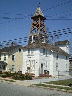
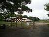
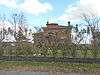
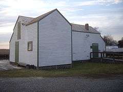
Bay Shore Hose Company No. 1 Firehouse |
|
000000002001-08-15-0000August 15, 2001
(#01000851) |
Second Avenue
40°43′29″N 73°14′46″W / 40.724722°N 73.246111°W / 40.724722; -73.246111 (Bay Shore Hose Company No. 1 Firehouse) |
Bay Shore |
|
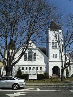
| 2 |
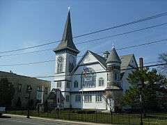
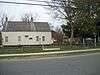
Bay Shore Methodist Episcopal Church |
|
000000002001-08-15-0000August 15, 2001
(#01000847) |
East Main Street, jct. Second Avenue
40°43′24″N 73°14′45″W / 40.723333°N 73.245833°W / 40.723333; -73.245833 (Bay Shore Methodist Episcopal Church) |
Bay Shore |
|
| 3 |
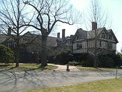
Bayard Cutting Estate |
|
000000001973-10-02-0000October 2, 1973
(#73001271) |
NY 27A, Great River
40°44′49″N 73°10′04″W / 40.746944°N 73.167778°W / 40.746944; -73.167778 (Bayard Cutting Estate) |
Great River |
Part of Bayard Cutting Arboretum State Park
|
| 4 |
Davis Field |
|
000000002008-01-22-0000January 22, 2008
(#07001456) |
2nd Street & 3rd Avenue
40°45′30″N 73°03′12″W / 40.758333°N 73.053333°W / 40.758333; -73.053333 (Davis Field) |
Bayport |
Also known as Bayport Aerodrome
|
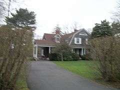
| 5 |
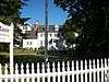
The Edwards House |
|
000000002010-12-07-0000December 7, 2010
(#10000988) |
39 Edwards St.
40°43′53″N 73°04′47″W / 40.731389°N 73.079722°W / 40.731389; -73.079722 (The Edwards House) |
Sayville |
Headquarters of the Sayville Historical Society
|
| 6 |
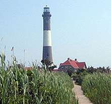
Fire Island Light Station |
|
000000001981-09-11-0000September 11, 1981
(#81000082) |
Robert Moses Causeway
40°37′55″N 73°13′08″W / 40.631944°N 73.218889°W / 40.631944; -73.218889 (Fire Island Light Station) |
Bay Shore |
Fire Island Light Station Historic District boundary increase (listed January 29, 2010, refnum 09001288): Burma Rd., Fire Island
|
| 7 |
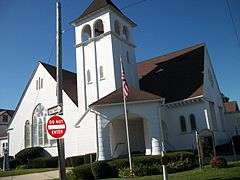
First Congregational Church of Bay Shore |
|
000000002002-05-03-0000May 3, 2002
(#02000448) |
1860 Union Boulevard
40°43′33″N 73°14′46″W / 40.725833°N 73.246111°W / 40.725833; -73.246111 (First Congregational Church of Bay Shore) |
Bay Shore |
|
| 8 |
Rafael Guastavino Jr. House |
|
000000002013-12-11-0000December 11, 2013
(#13000912) |
143 Awixa Avenue
40°43′00″N 73°14′03″W / 40.716667°N 73.234167°W / 40.716667; -73.234167 (Rafael Guastavino Jr. House) |
Bay Shore |
Unique Mediterranean-style house built in 1914, faced in fireproof ceramic tile, by inventor of tile.
|
| 9 |
Modern Times School |
|
000000001994-12-23-0000December 23, 1994
(#94001478) |
Jct. of Third Avenue and First Street
40°46′36″N 73°15′16″W / 40.776667°N 73.254444°W / 40.776667; -73.254444 (Modern Times School) |
Brentwood |
|
| 10 |
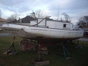
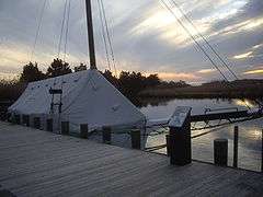
MODESTY (south-sider sloop) |
|
000000002001-08-07-0000August 7, 2001
(#01001051) |
86 West Avenue, Long Island Maritime Museum
40°43′22″N 73°05′43″W / 40.722778°N 73.095278°W / 40.722778; -73.095278 (MODESTY (south-sider sloop)) |
West Sayville |
|
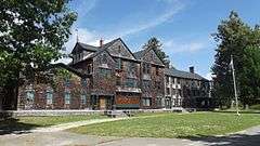
| 11 |
John Mollenhauer House |
|
000000002014-09-03-0000September 3, 2014
(#14000540) |
60 Awixa Ave.
40°43′21″N 73°14′06″W / 40.7225°N 73.235°W / 40.7225; -73.235 (John Mollenhauer House) |
Bay Shore |
1893 home of "Sugar King of Brooklyn" is excellent example of Shingle style estate
|
| 12 |
Jacob Ockers House |
|
000000001992-07-10-0000July 10, 1992
(#92000838) |
965 Montauk Highway
40°44′21″N 73°07′23″W / 40.739167°N 73.123056°W / 40.739167; -73.123056 (Jacob Ockers House) |
Oakdale |
|
| 13 |
Priscilla (Long Island Sound Oyster Sloop) |
|
000000002006-02-17-0000February 17, 2006
(#06000238) |
Waterfront, Long Island Maritime Museum,
86 West Avenue
40°43′21″N 73°05′45″W / 40.7225°N 73.095833°W / 40.7225; -73.095833 (Priscilla (Long Island Sound Oyster Sloop)) |
West Sayville |
|
| 14 |
John Ellis Roosevelt Estate |
Upload image |
000000001987-11-05-0000November 5, 1987
(#87001896) |
Middle Road
40°44′22″N 73°04′19″W / 40.739444°N 73.071944°W / 40.739444; -73.071944 (John Ellis Roosevelt Estate) |
Sayville |
|
| 15 |
Rudolph Oyster House |
|
000000002001-08-07-0000August 7, 2001
(#01001052) |
86 West Avenue, Long Island Maritime Museum
40°43′21″N 73°05′45″W / 40.7225°N 73.095833°W / 40.7225; -73.095833 (Rudolph Oyster House) |
West Sayville |
|
| 16 |
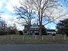
Sagtikos Manor |
|
000000001976-11-21-0000November 21, 1976
(#76001284) |
Montauk Highway (NY 27A)
40°42′10″N 73°16′36″W / 40.702778°N 73.276667°W / 40.702778; -73.276667 (Sagtikos Manor) |
West Bay Shore |
|
| 17 |
St. Ann's Episcopal Church |
|
000000002010-08-30-0000August 30, 2010
(#10000611) |
257 Middle Rd.
40°44′09″N 73°04′24″W / 40.735833°N 73.073333°W / 40.735833; -73.073333 (St. Ann's Episcopal Church) |
Sayville |
New listing, refnum 10000611; from Isaac Henry Green, Jr. Suffolk and Nassau Counties, New York MPS. (Official Site).
|
| 18 |
St. Johns Episcopal Church and Cemetery |
|
000000001994-01-28-0000January 28, 1994
(#93001559) |
Montauk Highway Northeast side, about 300' Northwest of the jct. with Locust Avenue
40°44′07″N 73°07′02″W / 40.735278°N 73.117222°W / 40.735278; -73.117222 (St. Johns Episcopal Church and Cemetery) |
Oakdale |
|
| 19 |
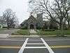
Sayville Congregational Church |
|
000000002005-07-27-0000July 27, 2005
(#05000747) |
131 Middle Road
40°44′11″N 73°04′50″W / 40.736389°N 73.080556°W / 40.736389; -73.080556 (Sayville Congregational Church) |
Sayville |
|
| 20 |
Southside Sportsmens Club District |
|
000000001973-07-23-0000July 23, 1973
(#73001272) |
Northeast of Great River, off NY 27
40°45′55″N 73°07′25″W / 40.765278°N 73.123611°W / 40.765278; -73.123611 (Southside Sportsmens Club District) |
Great River |
Part of Connetquot River State Park Preserve
|
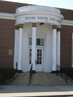
| 21 |
US Post Office-Bay Shore |
|
000000001988-11-17-0000November 17, 1988
(#88002455) |
10 Bay Shore Avenue
40°43′23″N 73°14′41″W / 40.723056°N 73.244722°W / 40.723056; -73.244722 (US Post Office-Bay Shore) |
Bay Shore |
|
| 22 |
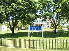
Wereholme |
Upload image |
000000002007-01-04-0000January 4, 2007
(#06001208) |
5500 South Bay Avenue
40°42′48″N 73°12′50″W / 40.713333°N 73.213889°W / 40.713333; -73.213889 (Wereholme) |
Islip |
|
| 23 |
Winganhauppauge |
Upload image |
000000002010-11-15-0000November 15, 2010
(#10000912) |
77 St. Marks Lane
40°43′32″N 73°12′15″W / 40.725556°N 73.204167°W / 40.725556; -73.204167 (Winganhauppauge) |
Islip |
New listing; refnum 10000912
|
| 24 |
Joseph Wood House |
|
000000002003-05-18-0000May 18, 2003
(#03000406) |
284 Greene Avenue
40°44′09″N 73°04′33″W / 40.735833°N 73.075833°W / 40.735833; -73.075833 (Joseph Wood House) |
Sayville |
|
.JPG)
.JPG)