| [2] |
Name on the Register |
Image |
Date listed[3] |
Location |
City or town |
Description |
|---|
| 1 |
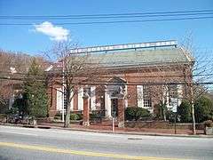
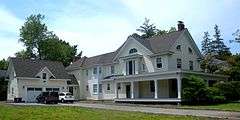
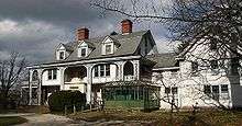
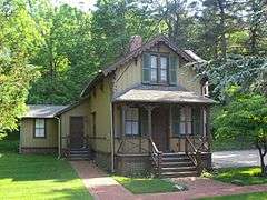
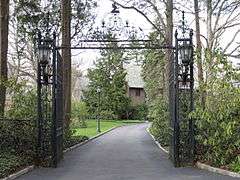
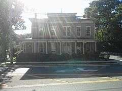
William Barstow Mansion |
Upload image |
000000002014-08-29-0000August 29, 2014
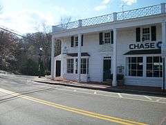
(#14000539) |
300 Steamboat Rd.
Coordinates missing |
Kings Point |
Gilded Age mansion built by founder of Kings Point and electricity pioneer now used as American Merchant Marine Museum
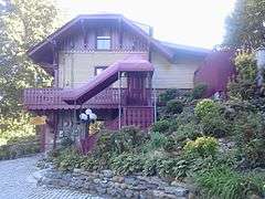
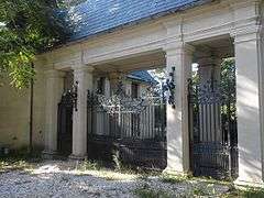
|
| 2 |
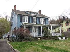
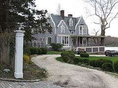
Cedarmere-Clayton Estates |
|
000000001986-09-29-0000September 29, 1986
(#86002634) |
Bryant Avenue and Northern Boulevard
40°48′36″N 73°38′22″W / 40.81°N 73.639444°W / 40.81; -73.639444 (Cedarmere-Clayton Estates) |
Roslyn Harbor |
Home of William Cullen Bryant and, later, Childs Frick; now part of the Nassau County Museum of Art
|
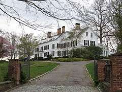
| 3 |
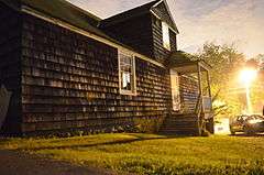
Clapham-Stern House |
|
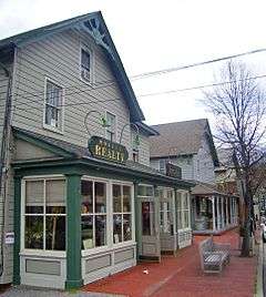
000000002005-06-10-0000June 10, 2005
(#05000570) |
48 Glenwood Road
40°49′15″N 73°38′49″W / 40.820833°N 73.646944°W / 40.820833; -73.646944 (Clapham-Stern House) |
Roslyn Harbor |
|
| 4 |
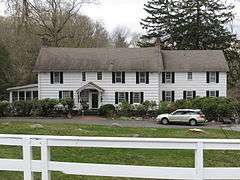
Clifton |
|
000000001999-07-22-0000July 22, 1999
(#99000874) |
355 Bryant Avenue
40°48′44″N 73°38′51″W / 40.812222°N 73.6475°W / 40.812222; -73.6475 (Clifton) |
Roslyn Harbor |
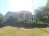
|
| 5 |
Cornell-Van Nostrand House |
Upload image |
000000002007-08-28-0000August 28, 2007
(#07000863) |
New Hyde Park Road and Marcus Avenue
40°45′33″N 73°41′15″W / 40.759167°N 73.6875°W / 40.759167; -73.6875 (Cornell-Van Nostrand House) |
New Hyde Park |
|
| 6 |
George W. Denton House |
Upload image |
000000001985-08-29-0000August 29, 1985
(#85001937) |
West Shore Road
40°48′16″N 73°39′19″W / 40.804444°N 73.655278°W / 40.804444; -73.655278 (George W. Denton House) |
Flower Hill |
|
| 7 |
Thomas Dodge Homestead |
|
000000001986-06-26-0000June 26, 1986
(#86001387) |
58 Harbor Road
40°50′20″N 73°41′51″W / 40.838889°N 73.6975°W / 40.838889; -73.6975 (Thomas Dodge Homestead) |
Port Washington |
|
| 8 |
East Williston Village Historic District |
Upload image |
000000001985-07-18-0000July 18, 1985
(#85001603) |
Roughly bounded by East Williston Avenue, Roslyn Road, Atlanta Avenue, and Village Green
40°45′28″N 73°38′18″W / 40.757778°N 73.638333°W / 40.757778; -73.638333 (East Williston Village Historic District) |
East Williston |
|
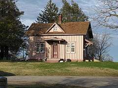
| 9 |
Eastman Cottage |
|
000000001986-10-02-0000October 2, 1986
(#86002635) |
130 Mott Avenue
40°48′09″N 73°39′16″W / 40.8025°N 73.654444°W / 40.8025; -73.654444 (Eastman Cottage) |
Roslyn |
|
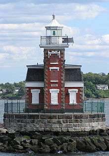
| 10 |
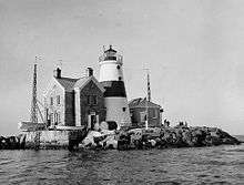
Execution Rocks Light Station |
|
000000002007-02-23-0000February 23, 2007
(#07000094) |
In Long Island Sound, 0.9 mi. NNW of N end of NY 101 in Nassau Co.
40°52′41″N 73°44′17″W / 40.878056°N 73.738056°W / 40.878056; -73.738056 (Execution Rocks Light Station) |
Port Washington |
|
| 11 |
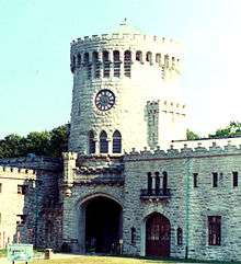
Gould-Guggenheim Estate |
|
000000002006-09-29-0000September 29, 2006
(#06000881) |
95 Middle Neck Road
40°51′34″N 73°41′47″W / 40.859444°N 73.696389°W / 40.859444; -73.696389 (Gould-Guggenheim Estate) |
Port Washington |
|
| 12 |
Grace and Thomaston Buildings |
|
000000001978-12-14-0000December 14, 1978
(#78001865) |
11 Middle Neck Road and 8 Bond Street
40°47′15″N 73°43′40″W / 40.7875°N 73.727778°W / 40.7875; -73.727778 (Grace and Thomaston Buildings) |
Great Neck Plaza |
|
| 13 |
Greenridge-Arthur Williams House |
|
000000001999-07-22-0000July 22, 1999
(#99000875) |
875 Bryant Avenue
40°49′00″N 73°37′49″W / 40.816667°N 73.630278°W / 40.816667; -73.630278 (Greenridge-Arthur Williams House) |
Roslyn Harbor |
|
| 14 |
Hicks Lumber Company Store |
|
000000001986-10-02-0000October 2, 1986
(#86002636) |
1345 Old Northern Boulevard
40°48′01″N 73°39′01″W / 40.800278°N 73.650278°W / 40.800278; -73.650278 (Hicks Lumber Company Store) |
Roslyn |
|
| 15 |
William Landsberg House |
|
000000002014-08-18-0000August 18, 2014
(#14000490) |
5 Tianderah Rd.
40°49′57″N 73°41′41″W / 40.83253°N 73.69470°W / 40.83253; -73.69470 (William Landsberg House) |
Port Washington |
Home designed and lived in by NY Architect William Landsberg
|
| 16 |
Mackay Estate Dairyman's Cottage |
|
000000001991-03-14-0000March 14, 1991
(#91000238) |
40 Elm Drive
40°48′02″N 73°37′32″W / 40.800556°N 73.625556°W / 40.800556; -73.625556 (Mackay Estate Dairyman's Cottage) |
East Hills |
|
| 17 |
Mackay Estate Gate Lodge |
|
000000001991-03-14-0000March 14, 1991
(#91000240) |
Jct. of Harbor Hill and Roslyn Roads
40°47′35″N 73°38′30″W / 40.793056°N 73.641667°W / 40.793056; -73.641667 (Mackay Estate Gate Lodge) |
East Hills |
|
| 18 |
Mackay Estate Water Tower |
|
000000001991-03-14-0000March 14, 1991
(#91000239) |
Redwood Drive between Lincoln Drive and Lufberry Drive
40°47′51″N 73°38′23″W / 40.7975°N 73.639722°W / 40.7975; -73.639722 (Mackay Estate Water Tower) |
East Hills |
|
| 19 |
Main Street Historic District |
|
000000001974-01-21-0000January 21, 1974
(#74001266) |
Main Street from North Hempstead Turnpike to East Broadway, including Tower Street and portions of Glen Avenue and Paper Mill Road
40°47′50″N 73°38′56″W / 40.797222°N 73.648889°W / 40.797222; -73.648889 (Main Street Historic District) |
Roslyn |
Mostly intact 18th- and 19th-century core of Roslyn
|
| 20 |
Main Street School |
|
000000001983-02-10-0000February 10, 1983
(#83001714) |
Main and South Washington Streets
40°49′50″N 73°41′48″W / 40.830556°N 73.696667°W / 40.830556; -73.696667 (Main Street School) |
Port Washington |
|
| 21 |
Manhasset Monthly Meeting of the Society of Friends |
|
000000002009-09-09-0000September 9, 2009
(#09000700) |
1421 Northern Boulevard
40°47′37″N 73°41′40″W / 40.793628°N 73.694386°W / 40.793628; -73.694386 (Manhasset Monthly Meeting of the Society of Friends) |
Manhasset |
New listing; refnum 09000700
|
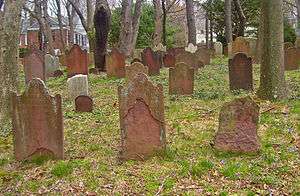
| 22 |
Monfort Cemetery |
|
000000001988-01-07-0000January 7, 1988
(#87002301) |
E of Main Street and Port Washington Boulevard
40°49′52″N 73°40′57″W / 40.831111°N 73.6825°W / 40.831111; -73.6825 (Monfort Cemetery) |
Port Washington |
Cemetery with remains of some early settlers of Cow Neck area.
|
| 23 |
Mudge Farmhouse |
|
000000001999-07-22-0000July 22, 1999
(#99000876) |
535 Motts Cove Road South
40°48′55″N 73°38′13″W / 40.815278°N 73.636944°W / 40.815278; -73.636944 (Mudge Farmhouse) |
Roslyn Harbor |
|
| 24 |
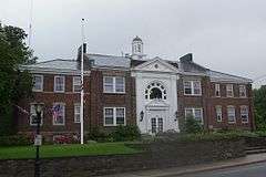
North Hempstead Town Hall |
|
000000002006-12-20-0000December 20, 2006
(#06001143) |
220 Plandome Road
40°47′44″N 73°41′56″W / 40.795556°N 73.698889°W / 40.795556; -73.698889 (North Hempstead Town Hall) |
Manhasset |
|
| 25 |
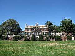
Old Westbury Gardens |
|
000000001976-11-08-0000November 8, 1976
(#76001234) |
71 Old Westbury Road
40°46′26″N 73°35′47″W / 40.773889°N 73.596389°W / 40.773889; -73.596389 (Old Westbury Gardens) |
Westbury |
|
| 26 |
Horatio Gates Onderdonk House |
|
000000001980-04-16-0000April 16, 1980
(#80002661) |
1471 Northern Boulevard
40°47′38″N 73°41′33″W / 40.793889°N 73.6925°W / 40.793889; -73.6925 (Horatio Gates Onderdonk House) |
Manhasset |
|
| 27 |
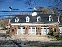
Rescue Hook & Ladder Company No. 1 Firehouse |
|
000000001991-05-06-0000May 6, 1991
(#91000480) |
Jct. of School Street and Skillman Street
40°48′10″N 73°38′48″W / 40.802778°N 73.646667°W / 40.802778; -73.646667 (Rescue Hook & Ladder Company No. 1 Firehouse) |
Roslyn |
|
| 28 |
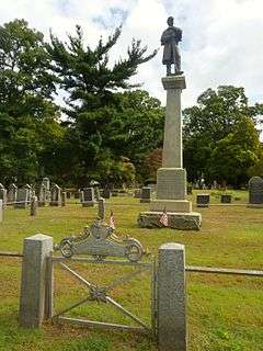
Roslyn Cemetery |
|
000000001991-10-28-0000October 28, 1991
(#91001534) |
Northern Boulevard, W of jct. with Glen Cove Road
40°48′33″N 73°37′56″W / 40.809167°N 73.632222°W / 40.809167; -73.632222 (Roslyn Cemetery) |
Greenvale |
|
| 29 |
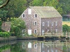
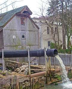
Roslyn Grist Mill |
|
000000001986-10-02-0000October 2, 1986
(#86002638) |
1347 Old Northern Boulevard
40°48′01″N 73°39′00″W / 40.800278°N 73.65°W / 40.800278; -73.65 (Roslyn Grist Mill) |
Roslyn |
One of the few remaining Dutch colonial commercial frame buildings in U.S.
|
| 30 |
Roslyn House |
|
000000001990-06-07-0000June 7, 1990
(#90000880) |
Jct. of Lincoln Avenue and Roslyn Road
40°47′31″N 73°38′28″W / 40.791944°N 73.641111°W / 40.791944; -73.641111 (Roslyn House) |
Roslyn Heights |
|
| 31 |
Roslyn National Bank and Trust Company Building |
|
000000001986-10-02-0000October 2, 1986
(#86002639) |
1432 Old Northern Boulevard
40°48′06″N 73°38′49″W / 40.801803°N 73.646931°W / 40.801803; -73.646931 (Roslyn National Bank and Trust Company Building) |
Roslyn |
|
| 32 |
Roslyn Savings Bank Building |
|
000000001986-10-02-0000October 2, 1986
(#86002640) |
1400 Old Northern Boulevard
40°48′03″N 73°38′52″W / 40.800833°N 73.647778°W / 40.800833; -73.647778 (Roslyn Savings Bank Building) |
Roslyn |
|
| 33 |
Roslyn Village Historic District |
|
000000001987-04-15-0000April 15, 1987
(#86002650) |
Roughly bounded by Old Northern Boulevard, Vernon and East Broadway Streets, Main, Glen Avenue, and Tower Street
40°47′49″N 73°38′54″W / 40.796944°N 73.648333°W / 40.796944; -73.648333 (Roslyn Village Historic District) |
Roslyn |
Later 19th-century western and commercial portion of Roslyn
|
| 34 |
Saddle Rock Grist Mill |
|
000000001978-12-27-0000December 27, 1978
(#78001866) |
Grist Mill Lane and Little Neck Bay
40°47′51″N 73°45′05″W / 40.7975°N 73.751389°W / 40.7975; -73.751389 (Saddle Rock Grist Mill) |
Saddle Rock |
|
| 35 |
Saint Mary's Chapel |
|
000000002005-04-06-0000April 6, 2005
(#05000270) |
Rushmore Avenue bet Roslyn Avenue and Glen Cove Avenue
40°45′04″N 73°36′35″W / 40.751111°N 73.609722°W / 40.751111; -73.609722 (Saint Mary's Chapel) |
Carle Place |
|
| 36 |
Sands Family Cemetery |
Upload image |
000000001992-03-12-0000March 12, 1992
(#92000092) |
Off Sands Point Road just S of jct. with Middle Neck Road
40°51′29″N 73°43′24″W / 40.858056°N 73.723333°W / 40.858056; -73.723333 (Sands Family Cemetery) |
Sands Point |
|
| 37 |
Sands-Willets Homestead |
Upload image |
000000001985-09-19-0000September 19, 1985
(#85002425) |
336 Port Washington Boulevard
40°48′56″N 73°40′51″W / 40.815556°N 73.680833°W / 40.815556; -73.680833 (Sands-Willets Homestead) |
Port Washington |
|
| 38 |
Almeron and Olive Smith House |
|
000000002006-07-12-0000July 12, 2006
(#06000569) |
50 South Drive
40°48′23″N 73°42′11″W / 40.806389°N 73.703056°W / 40.806389; -73.703056 (Almeron and Olive Smith House) |
Plandome |
|
| 39 |
Stephen and Charles Smith House |
|
000000001999-07-22-0000July 22, 1999
(#99000873) |
450 Bryant Avenue
40°48′47″N 73°38′45″W / 40.813056°N 73.645833°W / 40.813056; -73.645833 (Stephen and Charles Smith House) |
Roslyn Harbor |
|
| 40 |
John Philip Sousa House |
|
000000001966-10-15-0000October 15, 1966
(#66000532) |
14 Hicks Lane, Sands Point
40°50′35″N 73°43′47″W / 40.843056°N 73.729722°W / 40.843056; -73.729722 (John Philip Sousa House) |
Port Washington |
Home of John Philip Sousa, bandleader and composer of memorable marches, from 1915 to his death
|
| 41 |
Springbank |
|
000000001999-09-09-0000September 9, 1999
(#99001128) |
440 Bryant Avenue
40°48′46″N 73°38′45″W / 40.812778°N 73.645833°W / 40.812778; -73.645833 (Springbank) |
Roslyn Harbor |
|
| 42 |
Stepping Stones Light Station |
|
000000002005-09-15-0000September 15, 2005
(#05001026) |
Long Island Sound, 0.9 mi. NW of Elm Point at town of Kings Point
40°49′27″N 73°46′30″W / 40.824167°N 73.775°W / 40.824167; -73.775 (Stepping Stones Light Station) |
Kings Point |
|
| 43 |
Willet Titus House |
|
000000001986-10-02-0000October 2, 1986
(#86002652) |
1441 Old Northern Boulevard
40°48′11″N 73°38′50″W / 40.803056°N 73.647222°W / 40.803056; -73.647222 (Willet Titus House) |
Roslyn |
|
| 44 |
Toll Gate House |
|
000000001977-08-16-0000August 16, 1977
(#77000952) |
Northern Boulevard
40°48′31″N 73°37′56″W / 40.808611°N 73.632222°W / 40.808611; -73.632222 (Toll Gate House) |
Greenvale |
|
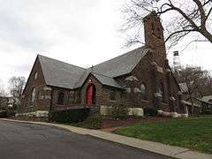
| 45 |
Trinity Church Complex |
|
000000001986-10-02-0000October 2, 1986
(#86002653) |
Northern Boulevard
40°48′18″N 73°38′44″W / 40.805°N 73.645556°W / 40.805; -73.645556 (Trinity Church Complex) |
Roslyn |
|
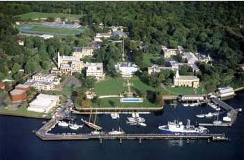
| 46 |
United States Merchant Marine Academy |
|
000000002014-08-29-0000August 29, 2014
(#14000538) |
300 Steamboat Road
40°48′44″N 73°45′48″W / 40.81219°N 73.76345°W / 40.81219; -73.76345 (United States Merchant Marine Academy) |
Kings Point |
Training site for members of the U.S. merchant marine since 1943
|
| 47 |
US Post Office-Great Neck |
|
000000001989-05-11-0000May 11, 1989
(#88002526) |
1 Welwyn Road
40°47′14″N 73°43′23″W / 40.787222°N 73.723056°W / 40.787222; -73.723056 (US Post Office-Great Neck) |
Great Neck Plaza |
|
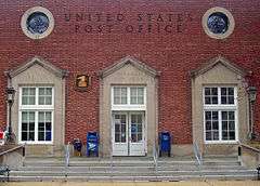
| 48 |
US Post Office-Mineola |
|
000000001989-05-11-0000May 11, 1989
(#88002354) |
Main and First Streets
40°44′35″N 73°38′21″W / 40.743056°N 73.639167°W / 40.743056; -73.639167 (US Post Office-Mineola) |
Mineola |
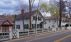
Only federal project designed by Peabody, Wilson & Brown, and rare New Deal post office without public art in lobby.
|
| 49 |
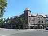
Valley Road Historic District |
Upload image |
000000001977-04-08-0000April 8, 1977
(#77000953) |
S of Manhasset on Community Drive
40°46′27″N 73°42′14″W / 40.774167°N 73.703889°W / 40.774167; -73.703889 (Valley Road Historic District) |
Manhasset |
|
| 50 |
Samuel Adams Warner House |
|
000000001986-10-02-0000October 2, 1986
(#86002654) |
1 Railroad Avenue
40°47′34″N 73°38′39″W / 40.792778°N 73.644167°W / 40.792778; -73.644167 (Samuel Adams Warner House) |
Roslyn |
|
| 51 |
Willowmere |
|
000000001999-07-22-0000July 22, 1999
(#99000872) |
435 Bryant Avenue
40°48′55″N 73°38′48″W / 40.815278°N 73.646667°W / 40.815278; -73.646667 (Willowmere) |
Roslyn Harbor |
|


.jpg)
-1.JPG)