| [2] |
Name on the Register |
Image |
Date listed[3] |
Location |
City or town |
Description |
|---|
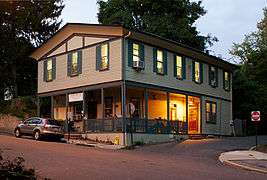
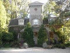
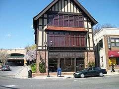
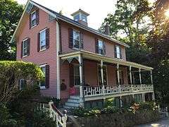
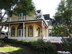
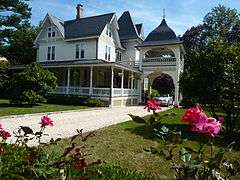
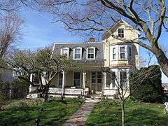
| 1 |
Adam-Derby House |
Upload image |
000000001979-05-17-0000May 17, 1979
(#79001597) |
166 Lexington Avenue
40°52′02″N 73°32′05″W / 40.867222°N 73.534722°W / 40.867222; -73.534722 (Adam-Derby House) |
Oyster Bay |
|
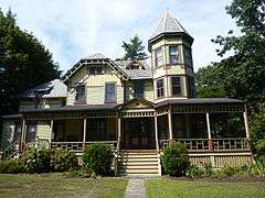
| 2 |
John E. Aldred Estate |
Upload image |
000000001979-08-03-0000August 3, 1979
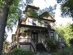
(#79001594) |
Lattingtown Road
40°53′40″N 73°36′59″W / 40.894444°N 73.616389°W / 40.894444; -73.616389 (John E. Aldred Estate) |
Lattingtown |
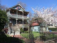
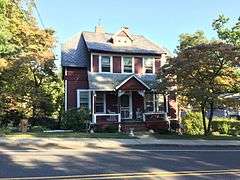
|
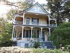
| 3 |
James William Beekman House |
Upload image |
000000001973-12-12-0000December 12, 1973
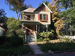
(#73001212) |
West Shore Road
40°52′45″N 73°32′49″W / 40.879167°N 73.546944°W / 40.879167; -73.546944 (James William Beekman House) |
Oyster Bay |
|
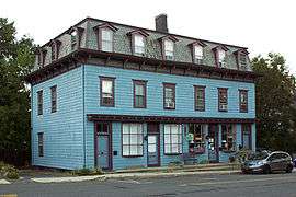
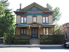
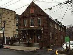
| 4 |
Central Hall |
|
000000001988-02-18-0000February 18, 1988
(#88000019) |
93 Central Avenue
40°50′54″N 73°38′54″W / 40.848333°N 73.648333°W / 40.848333; -73.648333 (Central Hall) |
Sea Cliff |
|
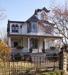
| 5 |
Christ Building |
|
000000002012-01-04-0000January 4, 2012
(#11001002) |
357-359 Sea Cliff Ave.
40°50′58″N 73°38′59″W / 40.849408°N 73.649589°W / 40.849408; -73.649589 (Christ Building) |
Sea Cliff |
|
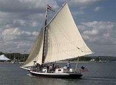
| 6 |
CHRISTEEN (oyster sloop) |
|
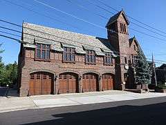
000000001991-12-04-0000December 4, 1991
(#91002060) |
Coordinates missing |
Oyster Bay |
Built in 1883, the oldest surviving oyster sloop in the U.S.
|
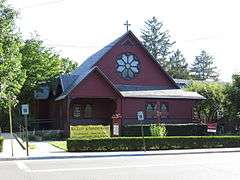
| 7 |
Church of Our Lady of Kazan |
Upload image |
000000002016-10-04-0000October 4, 2016
(#16000695) |
2 Willow Shore Ave.
Coordinates missing |
Sea Cliff |
1942 Orthodox church built by Russian emigrés displaced by early 20th-century upheavals at home.
|
| 8 |
Cock-Cornelius House |
Upload image |
000000002006-03-22-0000March 22, 2006
(#06000157) |
34 Birch Hill Road
40°52′27″N 73°35′17″W / 40.874167°N 73.588056°W / 40.874167; -73.588056 (Cock-Cornelius House) |
Locust Valley |
|
| 9 |
Cold Spring Harbor Laboratory Historic District |
|
000000001994-03-30-0000March 30, 1994
(#94000198) |
Jct. of NY 25A and Bungtown Road
40°51′43″N 73°28′02″W / 40.861944°N 73.467222°W / 40.861944; -73.467222 (Cold Spring Harbor Laboratory Historic District) |
Laurel Hollow |
|
| 10 |
Crowell House |
|
000000001988-02-18-0000February 18, 1988
(#88000020) |
375 Littleworth Lane
40°50′20″N 73°38′55″W / 40.838889°N 73.648611°W / 40.838889; -73.648611 (Crowell House) |
Sea Cliff |
|
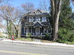
| 11 |
Lillian Sefton Dodge Estate |
|
000000001979-07-22-0000July 22, 1979
(#79001595) |
Frost Mill Road
40°52′39″N 73°33′34″W / 40.8775°N 73.559444°W / 40.8775; -73.559444 (Lillian Sefton Dodge Estate) |
Mill Neck |
|
| 12 |
DuPont-Guest Estate |
|
000000002009-12-11-0000December 11, 2009
(#09001084) |
S. side of Northern Blvd. between Cotillion Ct. & DuPont Ct.
40°48′32″N 73°36′53″W / 40.808975°N 73.614786°W / 40.808975; -73.614786 (DuPont-Guest Estate) |
Brookville |
|
| 13 |
Elmwood |
Upload image |
000000001975-04-03-0000April 3, 1975
(#75001200) |
E side of Cove Road
40°51′59″N 73°29′45″W / 40.866389°N 73.495833°W / 40.866389; -73.495833 (Elmwood) |
Oyster Bay |
|
| 14 |
First Presbyterian Church of Oyster Bay |
|
000000001976-12-12-0000December 12, 1976
(#76001232) |
E. Main Street
40°52′18″N 73°31′45″W / 40.871667°N 73.529167°W / 40.871667; -73.529167 (First Presbyterian Church of Oyster Bay) |
Oyster Bay |
|
| 15 |
Fort Massapeag Archeological Site |
Upload image |
000000001993-04-19-0000April 19, 1993
(#93000610) |
Address Restricted
|
Oyster Bay |
Site of only known remaining Native American fort on Long Island
|
| 16 |
Glen Cove Post Office |
|
000000002010-11-29-0000November 29, 2010
(#10000957) |
51 Glen St.
40°51′50″N 73°37′46″W / 40.863889°N 73.629444°W / 40.863889; -73.629444 (Glen Cove Post Office) |
Glen Cove |
|
| 17 |
A. Conger Goodyear House |
Upload image |
000000002003-12-04-0000December 4, 2003
(#03001246) |
14 Orchard Lane
40°48′04″N 73°35′24″W / 40.801111°N 73.59°W / 40.801111; -73.59 (A. Conger Goodyear House) |
Old Westbury |
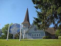
|
| 18 |
Grace Church Complex |
|
000000001983-06-30-0000June 30, 1983
(#83001713) |
Merrick and Dover Roads
40°40′01″N 73°27′33″W / 40.666944°N 73.459167°W / 40.666944; -73.459167 (Grace Church Complex) |
Massapequa |
|
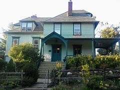
| 19 |
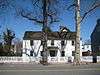
Stephen Harding House |
|
000000002011-08-24-0000August 24, 2011
(#11000597) |
182 14th Ave.
40°50′54″N 73°38′58″W / 40.848333°N 73.649444°W / 40.848333; -73.649444 (Stephen Harding House) |
Sea Cliff |
|
| 20 |
Heitz Place Courthouse |
|
000000001974-07-30-0000July 30, 1974
(#74001263) |
Heitz Place
40°46′08″N 73°31′16″W / 40.768889°N 73.521111°W / 40.768889; -73.521111 (Heitz Place Courthouse) |
Hicksville |
|
| 21 |
House at 9 Locust Place |
|
000000001988-02-18-0000February 18, 1988
(#88000030) |
9 Locust Place
40°50′40″N 73°39′05″W / 40.844444°N 73.651389°W / 40.844444; -73.651389 (House at 9 Locust Place) |
Sea Cliff |
|
| 22 |
House at 18 Seventeenth Avenue |
|
000000001988-02-18-0000February 18, 1988
(#88000011) |
18 Seventeenth Avenue
40°50′49″N 73°38′49″W / 40.846931°N 73.646961°W / 40.846931; -73.646961 (House at 18 Seventeenth Avenue) |
Sea Cliff |
|
| 23 |
House at 19 Locust Place |
|
000000001988-02-18-0000February 18, 1988
(#88000010) |
19 Locust Place
40°50′38″N 73°39′04″W / 40.843889°N 73.651111°W / 40.843889; -73.651111 (House at 19 Locust Place) |
Sea Cliff |
|
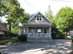
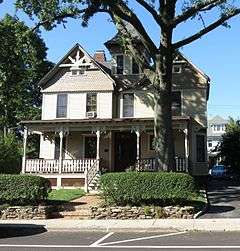
| 24 |
House at 52 Eighteenth Avenue |
|
000000001988-03-18-0000March 18, 1988
(#88000032) |
52 Eighteenth Avenue
40°50′48″N 73°39′01″W / 40.846667°N 73.650278°W / 40.846667; -73.650278 (House at 52 Eighteenth Avenue) |
Sea Cliff |
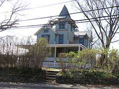
|
| 25 |
House at 52 Frost Mill Road |
Upload image |
000000002011-08-24-0000August 24, 2011
(#11000598) |
52 Frost Mill Road
40°53′13″N 73°33′39″W / 40.886944°N 73.560833°W / 40.886944; -73.560833 (House at 52 Frost Mill Road) |
Mill Neck |
|
| 26 |
House at 58 Eighteenth Avenue |
|
000000001988-02-18-0000February 18, 1988
(#88000002) |
58 Eighteenth Avenue
40°50′48″N 73°39′01″W / 40.846667°N 73.650278°W / 40.846667; -73.650278 (House at 58 Eighteenth Avenue) |
Sea Cliff |
|
| 27 |
House at 65 Twentieth Avenue |
|
000000001988-02-18-0000February 18, 1988
(#88000001) |
65 Twentieth Avenue
40°50′45″N 73°39′09″W / 40.845833°N 73.6525°W / 40.845833; -73.6525 (House at 65 Twentieth Avenue) |
Sea Cliff |
|
| 28 |
House at 103 Roslyn Avenue |
|
000000001988-02-18-0000February 18, 1988
(#88000018) |
103 Roslyn Avenue
40°50′51″N 73°38′43″W / 40.8475°N 73.645278°W / 40.8475; -73.645278 (House at 103 Roslyn Avenue) |
Sea Cliff |
|
| 29 |
House at 112 Sea Cliff Avenue |
|
000000001988-02-18-0000February 18, 1988
(#88000015) |
112 Sea Cliff Avenue
40°50′59″N 73°38′28″W / 40.849722°N 73.641111°W / 40.849722; -73.641111 (House at 112 Sea Cliff Avenue) |
Sea Cliff |
|
| 30 |
House at 115 Central Avenue |
|
000000001988-02-18-0000February 18, 1988
(#88000014) |
115 Central Avenue
40°50′49″N 73°38′53″W / 40.846944°N 73.648056°W / 40.846944; -73.648056 (House at 115 Central Avenue) |
Sea Cliff |
Also named "The Woodshed."
|
| 31 |
House at 137 Prospect Avenue |
|
000000001988-02-18-0000February 18, 1988
(#88000016) |
137 Prospect Avenue
40°50′54″N 73°39′02″W / 40.848333°N 73.650556°W / 40.848333; -73.650556 (House at 137 Prospect Avenue) |
Sea Cliff |
|
| 32 |
House at 173 Sixteenth Avenue |
|
000000001988-02-18-0000February 18, 1988
(#88000013) |
173 Sixteenth Avenue
40°50′51″N 73°39′10″W / 40.8475°N 73.652778°W / 40.8475; -73.652778 (House at 173 Sixteenth Avenue) |
Sea Cliff |
|
| 33 |
House at 176 Prospect Avenue |
|
000000001988-02-18-0000February 18, 1988
(#88000012) |
176 Prospect Avenue
40°50′54″N 73°39′03″W / 40.848333°N 73.650833°W / 40.848333; -73.650833 (House at 176 Prospect Avenue) |
Sea Cliff |
|
| 34 |
House at 195 Prospect Avenue |
|
000000001988-02-18-0000February 18, 1988
(#88000009) |
195 Prospect Avenue
40°50′49″N 73°39′04″W / 40.846944°N 73.651111°W / 40.846944; -73.651111 (House at 195 Prospect Avenue) |
Sea Cliff |
|
| 35 |
House at 199 Prospect Avenue |
|
000000001988-02-18-0000February 18, 1988
(#88000008) |
199 Prospect Avenue
40°50′49″N 73°39′04″W / 40.846944°N 73.651111°W / 40.846944; -73.651111 (House at 199 Prospect Avenue) |
Sea Cliff |
|
| 36 |
House at 207 Carpenter Avenue |
|
000000001988-02-18-0000February 18, 1988
(#88000007) |
207 Carpenter Avenue
40°50′56″N 73°38′31″W / 40.848889°N 73.641944°W / 40.848889; -73.641944 (House at 207 Carpenter Avenue) |
Sea Cliff |
|
| 37 |
House at 240 Sea Cliff Avenue |
|
000000001988-02-18-0000February 18, 1988
(#88000006) |
240 Sea Cliff Avenue
40°50′58″N 73°38′44″W / 40.849382°N 73.645594°W / 40.849382; -73.645594 (House at 240 Sea Cliff Avenue) |
Sea Cliff |
|
| 38 |
House at 285 Sea Cliff Avenue |
|
000000001988-02-18-0000February 18, 1988
(#88000005) |
285 Sea Cliff Avenue
40°50′55″N 73°38′50″W / 40.848611°N 73.647222°W / 40.848611; -73.647222 (House at 285 Sea Cliff Avenue) |
Sea Cliff |
|
| 39 |
House at 332 Franklin Avenue |
|
000000001988-02-18-0000February 18, 1988
(#88000038) |
332 Franklin Avenue
40°50′42″N 73°39′03″W / 40.845°N 73.650833°W / 40.845; -73.650833 (House at 332 Franklin Avenue) |
Sea Cliff |
|
| 40 |
House at 362 Sea Cliff Avenue |
|
000000001988-02-18-0000February 18, 1988
(#88000037) |
362 Sea Cliff Avenue
40°50′58″N 73°39′01″W / 40.849444°N 73.650278°W / 40.849444; -73.650278 (House at 362 Sea Cliff Avenue) |
Sea Cliff |
|
| 41 |
House at 378 Glen Avenue |
|
000000001988-02-18-0000February 18, 1988
(#88000033) |
378 Glen Avenue
40°50′44″N 73°39′04″W / 40.845556°N 73.651111°W / 40.845556; -73.651111 (House at 378 Glen Avenue) |
Sea Cliff |
|
| 42 |
Jericho Friends Meeting House Complex |
|
000000002002-05-10-0000May 10, 2002
(#02000473) |
6 Old Jericho Turnpike
40°47′40″N 73°32′12″W / 40.794444°N 73.536667°W / 40.794444; -73.536667 (Jericho Friends Meeting House Complex) |
Jericho |
|
| 43 |
Justice Court Building |
|
000000001990-04-26-0000April 26, 1990
(#90000691) |
Jct. of Town Path Extension and Glen Cove Highway
40°51′44″N 73°37′34″W / 40.862222°N 73.626111°W / 40.862222; -73.626111 (Justice Court Building) |
Glen Cove |
|
| 44 |
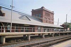
Long Island Rail Road Station at Farmingdale |
|
000000001991-11-13-0000November 13, 1991
(#91001677) |
Along LIRR tracks between Farmingdale and Forest Avenues
40°44′08″N 73°26′32″W / 40.735556°N 73.442222°W / 40.735556; -73.442222 (Long Island Rail Road Station at Farmingdale) |
Farmingdale |
|
| 45 |
Matinecock Friends Meetinghouse |
Upload image |
000000001976-07-19-0000July 19, 1976
(#76001231) |
Piping Rock and Duck Pond Roads
40°51′59″N 73°35′41″W / 40.866389°N 73.594722°W / 40.866389; -73.594722 (Matinecock Friends Meetinghouse) |
Locust Valley |
|
| 46 |
Moore's Building |
|
000000001996-09-30-0000September 30, 1996
(#96001043) |
1 East Main Street
40°52′18″N 73°31′37″W / 40.871667°N 73.526944°W / 40.871667; -73.526944 (Moore's Building) |
Oyster Bay |
|
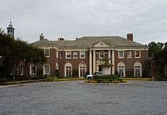
| 47 |
Benjamin Moore Estate |
Upload image |
000000001979-05-14-0000May 14, 1979
(#79001596) |
N of Muttontown on NY 25A
40°50′19″N 73°32′17″W / 40.838611°N 73.538056°W / 40.838611; -73.538056 (Benjamin Moore Estate) |
Muttontown |
|
| 48 |
Oyster Bay Long Island Rail Road Station |
|
000000002005-07-06-0000July 6, 2005
(#05000666) |
Railroad Avenue
40°53′13″N 73°31′43″W / 40.886944°N 73.528611°W / 40.886944; -73.528611 (Oyster Bay Long Island Rail Road Station) |
Oyster Bay |
|
| 49 |
Oyster Bay Long Island Rail Road Turntable |
|
000000002005-07-06-0000July 6, 2005
(#05000667) |
Railroad Avenue
40°52′38″N 73°31′43″W / 40.877222°N 73.528611°W / 40.877222; -73.528611 (Oyster Bay Long Island Rail Road Turntable) |
Oyster Bay |
|
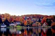
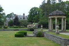
| 50 |
Planting Fields Arboretum |
|
000000001979-01-25-0000January 25, 1979
(#79001598) |
village of Upper Brookville on Planting Fields Road
40°51′29″N 73°33′29″W / 40.858056°N 73.558056°W / 40.858056; -73.558056 (Planting Fields Arboretum) |
Upper Brookville |
|
| 51 |
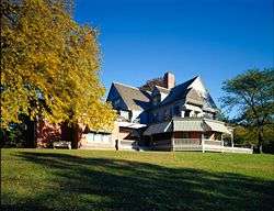
Raynham Hall |
|
000000001974-06-05-0000June 5, 1974
(#74001264) |
20 West Main Street
40°52′20″N 73°31′55″W / 40.872222°N 73.531944°W / 40.872222; -73.531944 (Raynham Hall) |
Oyster Bay |
|
| 52 |
James Alfred Roosevelt Estate |
Upload image |
000000001979-05-17-0000May 17, 1979
(#79001592) |
360 Cove Neck Road
40°53′02″N 73°30′29″W / 40.883889°N 73.508056°W / 40.883889; -73.508056 (James Alfred Roosevelt Estate) |
Cove Neck |
|
| 53 |
Sagamore Hill National Historic Site |
|
000000001966-10-15-0000October 15, 1966
(#66000096) |
End of Cove Neck Road
40°53′08″N 73°29′51″W / 40.885556°N 73.4975°W / 40.885556; -73.4975 (Sagamore Hill National Historic Site) |
Oyster Bay |
|
| 54 |
St. Luke's Protestant Episcopal Church |
|
000000001988-02-18-0000February 18, 1988
(#88000017) |
253 Glen Street
40°50′49″N 73°38′44″W / 40.846944°N 73.645556°W / 40.846944; -73.645556 (St. Luke's Protestant Episcopal Church) |
Sea Cliff |
|
| 55 |
Schenck-Mann House |
Upload image |
000000002005-02-24-0000February 24, 2005
(#05000089) |
222 Convent Road
40°49′19″N 73°29′25″W / 40.821944°N 73.490278°W / 40.821944; -73.490278 (Schenck-Mann House) |
Syosset |
|
| 56 |
Sea Cliff Firehouse |
|
000000002003-05-18-0000May 18, 2003
(#03000408) |
Roslyn Avenue
40°50′54″N 73°38′43″W / 40.848333°N 73.645278°W / 40.848333; -73.645278 (Sea Cliff Firehouse) |
Sea Cliff |
|
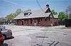
| 57 |
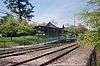
Sea Cliff Railroad Station |
|
000000001988-02-18-0000February 18, 1988
(#88000021) |
Sea Cliff Avenue
40°51′07″N 73°37′34″W / 40.851944°N 73.626111°W / 40.851944; -73.626111 (Sea Cliff Railroad Station) |
Glen Cove |
|
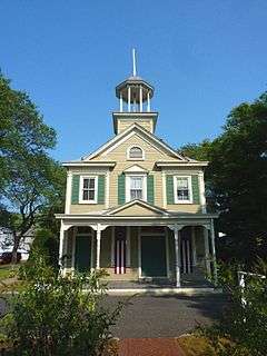
| 58 |
Sea Cliff Village Hall, Library and Museum Complex |
|
000000002005-04-22-0000April 22, 2005
(#05000328) |
300 Sea Cliff Avenue
40°50′58″N 73°38′50″W / 40.849435°N 73.64712°W / 40.849435; -73.64712 (Sea Cliff Village Hall, Library and Museum Complex) |
Sea Cliff |
|
| 59 |
Seawanhaka Corinthian Yacht Club |
|
000000001974-01-08-0000January 8, 1974
(#74001265) |
Centre Island Road
40°54′08″N 73°30′49″W / 40.902222°N 73.513611°W / 40.902222; -73.513611 (Seawanhaka Corinthian Yacht Club) |
Oyster Bay |
|
| 60 |
The Shell House |
Upload image |
000000001988-06-02-0000June 2, 1988
(#88000600) |
26 Westland Drive
40°53′52″N 73°38′03″W / 40.897778°N 73.634167°W / 40.897778; -73.634167 (The Shell House) |
Glen Cove |
|
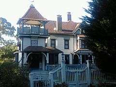
| 61 |
Edward H. Swan House |
Upload image |
000000001976-05-24-0000May 24, 1976
(#76001233) |
Cove Neck Road
40°52′38″N 73°30′12″W / 40.877222°N 73.503333°W / 40.877222; -73.503333 (Edward H. Swan House) |
Oyster Bay |
|
| 62 |
George Underhill House |
Upload image |
000000002003-07-05-0000July 5, 2003
(#03000592) |
28 Factory Pond Road
40°53′45″N 73°34′40″W / 40.895833°N 73.577778°W / 40.895833; -73.577778 (George Underhill House) |
Locust Valley |
|
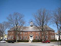
| 63 |
US Post Office-Glen Cove |
|
000000001989-05-11-0000May 11, 1989
(#88002525) |
2 Glen Cove Street
40°51′46″N 73°38′01″W / 40.862778°N 73.633611°W / 40.862778; -73.633611 (US Post Office-Glen Cove) |
Glen Cove |
|
| 64 |
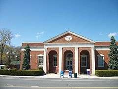
US Post Office-Oyster Bay |
|
000000001989-05-11-0000May 11, 1989
(#88002393) |
Shore Avenue
40°52′27″N 73°32′00″W / 40.874167°N 73.533333°W / 40.874167; -73.533333 (US Post Office-Oyster Bay) |
Oyster Bay |
|
| 65 |
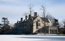
Woolworth Estate |
Upload image |
000000001979-05-17-0000May 17, 1979
(#79001593) |
77 Crescent Beach Road
40°52′31″N 73°38′38″W / 40.875278°N 73.643889°W / 40.875278; -73.643889 (Woolworth Estate) |
Glen Cove |
|