| [2] |
Name on the Register |
Image |
Date listed[3] |
Location |
City or town |
Description |
|---|
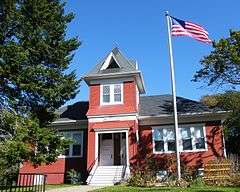
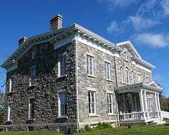
| 1 |
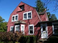
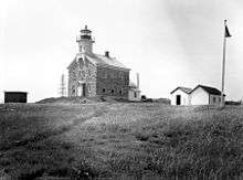
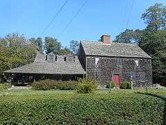
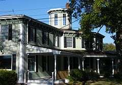
Brecknock Hall |
|
000000002005-04-22-0000April 22, 2005
(#05000331) |
North Road near Manhassett Avenue
41°07′00″N 72°21′43″W / 41.116667°N 72.361944°W / 41.116667; -72.361944 (Brecknock Hall) |
Stirling |
|
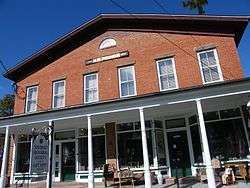
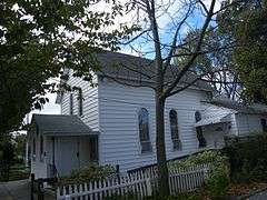
| 2 |
Congregation Tifereth Israel Synagogue |
|
000000002006-03-22-0000March 22, 2006
(#06000161) |
519 Fourth Street
41°06′02″N 72°21′55″W / 41.100556°N 72.365278°W / 41.100556; -72.365278 (Congregation Tifereth Israel Synagogue) |
Greenport |
|
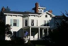
| 3 |
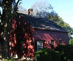
Richard Cox House |
|
000000001986-08-21-0000August 21, 1986
(#86001721) |
Mill Road
40°59′55″N 72°33′28″W / 40.998611°N 72.557778°W / 40.998611; -72.557778 (Richard Cox House) |
Mattituck |
|
| 4 |
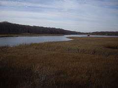
Fort Corchaug Archeological Site |
|
000000001974-01-18-0000January 18, 1974
(#74001308) |
Address Restricted
|
Cutchogue |
|
| 5 |
Andrew Gildersleeve Octagonal Building |
|
000000001976-08-19-0000August 19, 1976
(#76001280) |
Main Road and Love Lane
40°59′28″N 72°31′25″W / 40.991111°N 72.523611°W / 40.991111; -72.523611 (Andrew Gildersleeve Octagonal Building) |
Mattituck |
|
| 6 |
Greenport Railroad Station |
|
000000001989-07-20-0000July 20, 1989
(#89000947) |
Third and Wiggins Streets
41°05′59″N 72°21′49″W / 41.099722°N 72.363611°W / 41.099722; -72.363611 (Greenport Railroad Station) |
Greenport |
|
| 7 |
Greenport Village Historic District |
|
000000001984-09-13-0000September 13, 1984
(#84002973) |
Roughly bounded by Stirling Basin, Main, Monsell, 2nd, and Front Streets
41°06′17″N 72°21′53″W / 41.104722°N 72.364722°W / 41.104722; -72.364722 (Greenport Village Historic District) |
Greenport |
|
| 8 |
Joseph Nelson Hallock House |
|
000000002005-04-22-0000April 22, 2005
(#05000330) |
Main Road and Maple Avenue
41°03′55″N 72°25′26″W / 41.065278°N 72.423889°W / 41.065278; -72.423889 (Joseph Nelson Hallock House) |
Southold |
|
| 9 |
Horton Point Lighthouse |
|
000000001994-10-21-0000October 21, 1994
(#94001237) |
N end of Lighthouse Road
41°05′07″N 72°26′47″W / 41.085278°N 72.446389°W / 41.085278; -72.446389 (Horton Point Lighthouse) |
Southold |
|
| 10 |
Samuel Landon House |
|
000000002005-04-20-0000April 20, 2005
(#05000329) |
Main Road Bet. Hobart Road and Maple Lane
41°03′57″N 72°25′25″W / 41.065833°N 72.423611°W / 41.065833; -72.423611 (Samuel Landon House) |
Southold |
|
| 11 |
Latimer Reef Light Station |
|
000000002006-07-19-0000July 19, 2006
(#06000635) |
In Fisher's Island Sound, one mi NW of East Point on Fisher's Island
41°18′15″N 71°56′02″W / 41.304167°N 71.933889°W / 41.304167; -71.933889 (Latimer Reef Light Station) |
Fisher's Island |
|
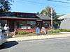
| 12 |
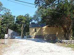
New Suffolk School |
|
000000002002-09-12-0000September 12, 2002
(#02001050) |
Fifth Street at King Street
40°59′32″N 72°28′32″W / 40.992222°N 72.475556°W / 40.992222; -72.475556 (New Suffolk School) |
New Suffolk |
|
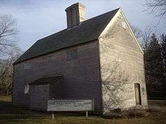
| 13 |
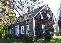
The Old House |
|
000000001966-10-15-0000October 15, 1966
(#66000573) |
NY 25
41°00′29″N 72°29′10″W / 41.008056°N 72.486111°W / 41.008056; -72.486111 (The Old House) |
Cutchogue |
|
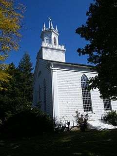
| 14 |
Orient Historic District |
|
000000001976-05-21-0000May 21, 1976
(#76001283) |
NY 25
41°08′21″N 72°18′11″W / 41.139167°N 72.303056°W / 41.139167; -72.303056 (Orient Historic District) |
Orient |
|
| 15 |
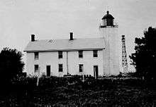
Orient Point Light Station |
|
000000002007-01-09-0000January 9, 2007
(#06001229) |
NE tip of Long Island, 1.1 mi. NE of Eastern Terminus of NY 25
41°09′48″N 72°13′27″W / 41.163333°N 72.224167°W / 41.163333; -72.224167 (Orient Point Light Station) |
Orient |
|
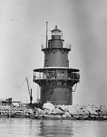
| 16 |
Plum Island Light Station |
|
000000002011-02-11-0000February 11, 2011
(#11000014) |
NW corner of Plum Island
41°10′25″N 72°12′41″W / 41.173611°N 72.211389°W / 41.173611; -72.211389 (Plum Island Light Station) |
Orient Point |
New listing; refnum 11000014; Light Stations of the United States MPS
|
| 17 |
Henry W. Prince Building |
|
000000002005-02-24-0000February 24, 2005
(#05000091) |
54325 Main Road
41°03′53″N 72°25′40″W / 41.064722°N 72.427778°W / 41.064722; -72.427778 (Henry W. Prince Building) |
Southold |
|
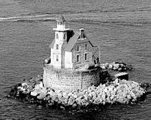
| 18 |
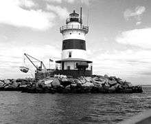
Race Rock Light Station |
|
000000002005-04-29-0000April 29, 2005
(#05000347) |
0.6 mi. SW of Race Point
41°14′44″N 72°02′49″W / 41.245556°N 72.046944°W / 41.245556; -72.046944 (Race Rock Light Station) |
Fishers Island |
|
| 19 |
Southold Historic District |
|
000000001997-10-14-0000October 14, 1997
(#97001202) |
Along Main Road, roughly bounded by Jockey Creek Drive, Griswold Street, Long Island RR Tracks, and Wells Road
41°03′35″N 72°26′01″W / 41.059722°N 72.433611°W / 41.059722; -72.433611 (Southold Historic District) |
Southold |
|
| 20 |
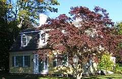
Terry-Mulford House |
|
000000001984-02-07-0000February 7, 1984
(#84003003) |
NY 25
41°09′06″N 72°16′38″W / 41.151667°N 72.277222°W / 41.151667; -72.277222 (Terry-Mulford House) |
Orient |
|
| 21 |
Town Doctors' House and Site |
|
000000002005-01-05-0000January 5, 2005
(#04001448) |
310 Ackerly Pond Lane
41°03′25″N 72°26′12″W / 41.056944°N 72.436667°W / 41.056944; -72.436667 (Town Doctors' House and Site) |
Southold |
|
| 22 |
David Tuthill Farmstead |
|
000000001984-11-23-0000November 23, 1984
(#84000295) |
New Suffolk Lane
41°00′25″N 72°29′39″W / 41.006944°N 72.494167°W / 41.006944; -72.494167 (David Tuthill Farmstead) |
Cutchogue |
|
| 23 |
Jesse and Ira Tuthill House |
|
000000002006-03-22-0000March 22, 2006
(#06000158) |
Main Road and Cardinal Drive
40°59′49″N 72°31′11″W / 40.996944°N 72.519722°W / 40.996944; -72.519722 (Jesse and Ira Tuthill House) |
Mattituck |
|
| 24 |
Joshua Wells House |
|
000000002002-03-06-0000March 6, 2002
(#02000139) |
525 New Suffolk Road
41°00′35″N 72°29′05″W / 41.009722°N 72.484722°W / 41.009722; -72.484722 (Joshua Wells House) |
Cutchogue |
|
.jpg)