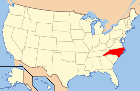
| [3] |
Name on the Register[4] |
Image |
Date listed[5] |
Location |
City or town |
Description |
|---|
| 1 |
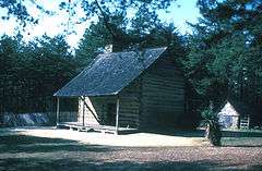
Alamance Battleground State Historic Site |
|
000000001970-02-26-0000February 26, 1970
(#70000435) |
SW of Burlington on Rte. 1, off NC 62, near jct. with Rte. 1129
36°00′27″N 79°31′12″W / 36.0075°N 79.52°W / 36.0075; -79.52 (Alamance Battleground State Historic Site) |
Alamance |
|
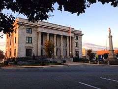
| 2 |
Alamance County Courthouse |
|
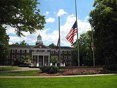
000000001979-05-10-0000May 10, 1979
(#79001655) |
Courthouse Square
36°04′09″N 79°24′02″W / 36.069167°N 79.400556°W / 36.069167; -79.400556 (Alamance County Courthouse) |
Graham |
|
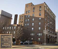
| 3 |
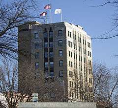
Alamance Hotel |
|
000000001984-05-31-0000May 31, 1984
(#84001906) |
Maple Ave. and S. Main St.
36°05′35″N 79°26′24″W / 36.093056°N 79.44°W / 36.093056; -79.44 (Alamance Hotel) |
Burlington |
|
| 4 |
Alamance Mill Village Historic District |
Upload image |
000000002007-08-16-0000August 16, 2007
(#07000821) |
3927-3981 NC 62 S, Great Alamance Creek W of NC 62S
36°02′22″N 79°29′14″W / 36.039531°N 79.487294°W / 36.039531; -79.487294 (Alamance Mill Village Historic District) |
Alamance |
|
| 5 |
Allen House |
|
000000001970-02-26-0000February 26, 1970
(#70000436) |
SW of Burlington on Rte. 1, off SC 62
36°00′33″N 79°31′16″W / 36.009167°N 79.521111°W / 36.009167; -79.521111 (Allen House) |
Burlington |
|
| 6 |
Altamahaw Mill Office |
Upload image |
000000001984-11-20-0000November 20, 1984
(#84000301) |
SR 1002 and SR 1567
36°11′02″N 79°30′27″W / 36.183889°N 79.5075°W / 36.183889; -79.5075 (Altamahaw Mill Office) |
Altamahaw |
|
| 7 |
Atlantic Bank and Trust Company Building |
|
000000001984-05-31-0000May 31, 1984
(#84001909) |
358 S. Main St.
36°05′36″N 79°26′15″W / 36.093333°N 79.4375°W / 36.093333; -79.4375 (Atlantic Bank and Trust Company Building) |
Burlington |
|
| 8 |
Bellemont Mill Village Historic District |
Upload image |
000000001987-07-01-0000July 1, 1987
(#87001099) |
E and W side of NC 49, S of jct. with Great Alamance Creek
36°01′33″N 79°26′34″W / 36.025833°N 79.442778°W / 36.025833; -79.442778 (Bellemont Mill Village Historic District) |
Bellemont |
|
| 9 |
Beverly Hills Historic District |
Upload image |
000000002009-08-05-0000August 5, 2009
(#09000599) |
Portion of 14 blocks on N. Main St., Rolling Rd., Highland Ave., Virginia Ave., N. Ireland St., N. St. John St.
36°05′54″N 79°25′28″W / 36.098378°N 79.424464°W / 36.098378; -79.424464 (Beverly Hills Historic District) |
Burlington |
|
| 10 |
Hiram Braxton House |
Upload image |
000000001993-11-22-0000November 22, 1993
(#93001193) |
3440 Newlin Rd.
35°52′06″N 79°19′06″W / 35.868333°N 79.318333°W / 35.868333; -79.318333 (Hiram Braxton House) |
Snow Camp |
|
| 11 |
Charles F. and Howard Cates Farm |
Upload image |
000000002001-09-24-0000September 24, 2001
(#01001025) |
4870 Mebane Rogers Rd.
36°06′48″N 79°16′47″W / 36.113333°N 79.279722°W / 36.113333; -79.279722 (Charles F. and Howard Cates Farm) |
Mebane |
|
| 12 |
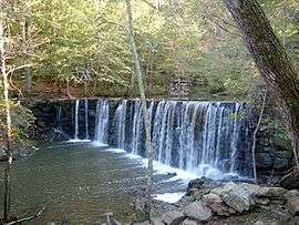
Cedarock Park Historic District |
|
000000001986-12-04-0000December 4, 1986
(#86003455) |
SR 2409
35°59′26″N 79°26′30″W / 35.990556°N 79.441667°W / 35.990556; -79.441667 (Cedarock Park Historic District) |
Graham |
|
| 13 |
William Cook House |
Upload image |
000000001993-11-22-0000November 22, 1993
(#93001194) |
NC 2131 W side at jct. with NC 2132
36°01′59″N 79°17′03″W / 36.033056°N 79.284167°W / 36.033056; -79.284167 (William Cook House) |
Mebane |
|
| 14 |
Cooper School |
Upload image |
000000001986-12-15-0000December 15, 1986
(#86003451) |
S side of SR 2143, E of jct. with SR 2142
35°59′30″N 79°16′19″W / 35.991667°N 79.271944°W / 35.991667; -79.271944 (Cooper School) |
Mebane |
|
| 15 |
Cross Roads Presbyterian Church and Cemetery and Stainback Store |
|
000000001984-05-22-0000May 22, 1984
(#84001912) |
N of Mebane at SR 1910 and SR 1912
36°10′12″N 79°17′11″W / 36.17°N 79.286389°W / 36.17; -79.286389 (Cross Roads Presbyterian Church and Cemetery and Stainback Store) |
Mebane |
|
| 16 |
Downtown Burlington Historic District |
Upload image |
000000001990-09-06-0000September 6, 1990
(#90001320) |
Roughly bounded by Morehead, S. Main, Davis, S. Worth, E. Webb and Spring Sts.
36°05′33″N 79°26′18″W / 36.0925°N 79.438333°W / 36.0925; -79.438333 (Downtown Burlington Historic District) |
Burlington |
|
| 17 |
Durham Hosiery Mill No. 15 |
Upload image |
000000002010-12-27-0000December 27, 2010
(#10001054) |
301 W. Washington St.
36°05′48″N 79°16′25″W / 36.096667°N 79.273611°W / 36.096667; -79.273611 (Durham Hosiery Mill No. 15) |
Mebane |
|
| 18 |
East Davis Street Historic District |
Upload image |
000000002000-04-20-0000April 20, 2000
(#00000393) |
Roughly bounded by E. Davis St., S. Mebane St., E. Webb Ave., and Tucker St.
36°05′17″N 79°25′52″W / 36.088056°N 79.431111°W / 36.088056; -79.431111 (East Davis Street Historic District) |
Burlington |
|
| 19 |
Efird Building |
Upload image |
000000001984-05-31-0000May 31, 1984
(#84001914) |
133 E. Davis St.
36°05′34″N 79°26′16″W / 36.092778°N 79.437778°W / 36.092778; -79.437778 (Efird Building) |
Burlington |
|
| 20 |
Elon College Historic District |
|
000000001988-03-22-0000March 22, 1988
(#88000166) |
S side of Haggard Ave. between William and O'Kelly
36°06′07″N 79°30′17″W / 36.101944°N 79.504722°W / 36.101944; -79.504722 (Elon College Historic District) |
Elon |
|
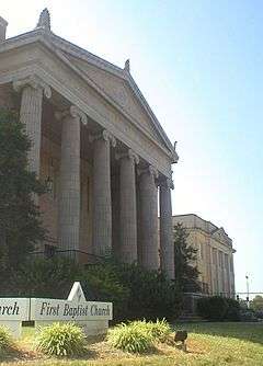
| 21 |
First Baptist Church |
|
000000001984-05-31-0000May 31, 1984
(#84001917) |
400 S. Broad St.
36°05′24″N 79°26′04″W / 36.09°N 79.434444°W / 36.09; -79.434444 (First Baptist Church) |
Burlington |
|
| 22 |
First Christian Church of Burlington |
|
000000001984-05-31-0000May 31, 1984
(#84001919) |
415 S. Church St.
36°05′41″N 79°26′23″W / 36.094722°N 79.439722°W / 36.094722; -79.439722 (First Christian Church of Burlington) |
Burlington |
|
| 23 |
Polly Fogleman House |
Upload image |
000000001993-11-22-0000November 22, 1993
(#93001197) |
4331 Brick Church Rd.
36°00′27″N 79°32′18″W / 36.0075°N 79.538333°W / 36.0075; -79.538333 (Polly Fogleman House) |
Burlington |
|
| 24 |
Friends Spring Meeting House |
Upload image |
000000001987-03-19-0000March 19, 1987
(#87000456) |
Jct. of SR 1005 and SR 2338
35°54′07″N 79°19′34″W / 35.901944°N 79.326111°W / 35.901944; -79.326111 (Friends Spring Meeting House) |
Snow Camp |
|
| 25 |
Glencoe Mill Village Historic District |
|
000000001979-02-16-0000February 16, 1979
(#79001654) |
Off NC 62 at Haw River
36°08′27″N 79°25′44″W / 36.140833°N 79.428889°W / 36.140833; -79.428889 (Glencoe Mill Village Historic District) |
Glencoe |
|
| 26 |
Glencoe School |
Upload image |
000000002010-12-27-0000December 27, 2010
(#10001055) |
2649 Union Ridge Rd.
36°08′48″N 79°25′25″W / 36.146667°N 79.423611°W / 36.146667; -79.423611 (Glencoe School) |
Glencoe |
|
| 27 |
Graham Historic District |
Upload image |
000000001983-04-07-0000April 7, 1983
(#83001834) |
E. and W. Harden, E. and W. Elm, N. and S. Main and W. Pine Sts.
36°04′08″N 79°24′09″W / 36.068889°N 79.4025°W / 36.068889; -79.4025 (Graham Historic District) |
Graham |
|
| 28 |
Griffis-Patton House |
Upload image |
000000001983-03-17-0000March 17, 1983
(#83001835) |
NW of Melbane on SR 1927
36°07′01″N 79°19′03″W / 36.116944°N 79.3175°W / 36.116944; -79.3175 (Griffis-Patton House) |
Mebane |
|
| 29 |
Thomas Guy House |
Upload image |
000000001993-11-22-0000November 22, 1993
(#93001195) |
NC 2135 N side, 0.3 miles W of jct. with NC 2142
36°00′34″N 79°16′06″W / 36.009444°N 79.268333°W / 36.009444; -79.268333 (Thomas Guy House) |
Mebane |
|
| 30 |
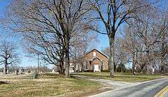
Hawfields Presbyterian Church |
Upload image |
000000001978-12-15-0000December 15, 1978
(#78001926) |
SW of Mebane on NC 119
36°03′28″N 79°18′23″W / 36.057778°N 79.306389°W / 36.057778; -79.306389 (Hawfields Presbyterian Church) |
Mebane |
|
| 31 |
Henderson Scott Farm Historic District |
Upload image |
000000001987-09-16-0000September 16, 1987
(#87000411) |
Jct. of NC 119 and SR 2135
36°02′23″N 79°19′53″W / 36.039722°N 79.331389°W / 36.039722; -79.331389 (Henderson Scott Farm Historic District) |
Mebane |
|
| 32 |
Charles T. Holt House |
Upload image |
000000001982-06-01-0000June 1, 1982
(#82003421) |
228 Holt St.
36°05′09″N 79°22′11″W / 36.085833°N 79.369722°W / 36.085833; -79.369722 (Charles T. Holt House) |
Haw River |
Designed by architect George Franklin Barber
|
| 33 |
L. Banks Holt House |
Upload image |
000000001977-04-18-0000April 18, 1977
(#77000988) |
S of Alamance on NC 62
36°01′08″N 79°29′30″W / 36.018889°N 79.491667°W / 36.018889; -79.491667 (L. Banks Holt House) |
Alamance |
|
| 34 |
Holt-Frost House |
Upload image |
000000001984-05-31-0000May 31, 1984
(#84001920) |
130 Union Ave.
36°05′59″N 79°26′19″W / 36.099722°N 79.438611°W / 36.099722; -79.438611 (Holt-Frost House) |
Burlington |
|
| 35 |
Horner Houses |
Upload image |
000000001984-05-31-0000May 31, 1984
(#84001921) |
304 and 308 N. Fisher St.
36°05′59″N 79°26′12″W / 36.099722°N 79.436667°W / 36.099722; -79.436667 (Horner Houses) |
Burlington |
|
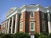
| 36 |
Johnston Hall |
|
000000001994-03-07-0000March 7, 1994
(#94000130) |
103 Antioch St.
36°06′01″N 79°30′01″W / 36.100278°N 79.500278°W / 36.100278; -79.500278 (Johnston Hall) |
Elon |
|
| 37 |
Kernodle-Pickett House |
Upload image |
000000001987-03-23-0000March 23, 1987
(#87000454) |
Jct. of NC 1136 and NC 1131
36°01′18″N 79°27′43″W / 36.021667°N 79.461944°W / 36.021667; -79.461944 (Kernodle-Pickett House) |
Bellemont |
|
| 38 |
Kerr-Patton House |
Upload image |
000000001985-12-05-0000December 5, 1985
(#85003083) |
NC 2133
36°01′37″N 79°18′48″W / 36.026944°N 79.313333°W / 36.026944; -79.313333 (Kerr-Patton House) |
Thompson |
|
| 39 |
Lakeside Mills Historic District |
|
000000001984-05-31-0000May 31, 1984
(#84001922) |
404-418 Lakeside Ave., Kent Ave., and 428-437 Hatch St.
36°06′18″N 79°26′21″W / 36.105°N 79.439167°W / 36.105; -79.439167 (Lakeside Mills Historic District) |
Burlington |
|
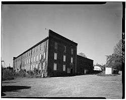
| 40 |
May Hosiery Mills Knitting Mill |
Upload image |
000000002016-08-26-0000August 26, 2016
(#16000585) |
612 S. Main St.
36°05′31″N 79°26′23″W / 36.091829°N 79.439852°W / 36.091829; -79.439852 (May Hosiery Mills Knitting Mill) |
Burlington |
|
| 41 |
Camilus McBane House |
Upload image |
000000001993-11-22-0000November 22, 1993
(#93001196) |
Off NC 2345 N side, 0.3 miles W of jct. with NC 2340, 0.2 miles down unnamed rd.
35°52′43″N 79°18′49″W / 35.878611°N 79.313611°W / 35.878611; -79.313611 (Camilus McBane House) |
Snow Camp |
|
| 42 |
McCauley-Watson House |
Upload image |
000000001994-02-04-0000February 4, 1994
(#94000022) |
NC 1762 (Blanchard Rd.) SW side, 1.5 miles NW of jct. with NC 62
36°11′23″N 79°23′48″W / 36.189722°N 79.396667°W / 36.189722; -79.396667 (McCauley-Watson House) |
Union Ridge |
|
| 43 |
McCray School |
Upload image |
000000001986-12-04-0000December 4, 1986
(#86003438) |
NW side of NC 62, S of jct. with SR 1757
36°10′49″N 79°22′48″W / 36.180278°N 79.38°W / 36.180278; -79.38 (McCray School) |
Burlington |
|
| 44 |
Mebane Commercial Historic District |
Upload image |
000000002011-12-22-0000December 22, 2011
(#11000952) |
Bounded by N. 3rd, E. Center, N. 4th, & W. Clay Sts.
36°05′49″N 79°16′07″W / 36.096947°N 79.268564°W / 36.096947; -79.268564 (Mebane Commercial Historic District) |
Mebane |
|
| 45 |
Menagerie Carousel |
Upload image |
000000001982-08-30-0000August 30, 1982
(#82003420) |
Burlington City Park, S. Main St.
36°05′03″N 79°27′13″W / 36.084167°N 79.453611°W / 36.084167; -79.453611 (Menagerie Carousel) |
Burlington |
|
| 46 |
Moore-Holt-White House |
Upload image |
000000001984-05-31-0000May 31, 1984
(#84001924) |
520 Maple ave.
36°05′19″N 79°26′06″W / 36.088611°N 79.435°W / 36.088611; -79.435 (Moore-Holt-White House) |
Burlington |
|
| 47 |
William P. Morrow House |
Upload image |
000000002006-08-09-0000August 9, 2006
(#06000687) |
NC 2146, 0.1 miles W of jct. with NC 2145 (3017 Saxapahaw-Bethlehem Church Rd.)
35°57′15″N 79°16′45″W / 35.954167°N 79.279167°W / 35.954167; -79.279167 (William P. Morrow House) |
Graham |
|
| 48 |
North Main Street Historic District |
Upload image |
000000001999-06-10-0000June 10, 1999
(#99000698) |
Roughly bounded by Whitsett, New Hill, N. Melville, Market, Mill and Sideview Sts.
36°04′30″N 79°23′57″W / 36.075°N 79.399167°W / 36.075; -79.399167 (North Main Street Historic District) |
Graham |
|
| 49 |
Old South Mebane Historic District |
Upload image |
000000002011-12-22-0000December 22, 2011
(#11000953) |
Bounded by Holt, S. 1st, S. 5th, Austin, E. Wilson, & Roosevelt Sts.; also 400 blks. of W. Lee & W. McKinley Sts., 507 S. 4th St., 600-800 blks. of S. 5th St.
36°05′33″N 79°16′17″W / 36.092578°N 79.271325°W / 36.092578; -79.271325 (Old South Mebane Historic District) |
Mebane |
Second address represents a boundary increase of 000000002013-12-16-0000December 16, 2013
|
| 50 |
Oneida Cotton Mills and Scott-Mebane Manufacturing Company Complex |
|
000000002014-06-09-0000June 9, 2014
(#14000291) |
219 & 220 W. Harden St.
36°04′14″N 79°24′15″W / 36.07065°N 79.404041°W / 36.07065; -79.404041 (Oneida Cotton Mills and Scott-Mebane Manufacturing Company Complex) |
Graham |
|
| 51 |
Former Saxapahaw Spinning Mill |
Upload image |
000000001998-05-20-0000May 20, 1998
(#98000546) |
1647 Saxapahaw Bethlehem Church Rd.
35°56′48″N 79°19′16″W / 35.946667°N 79.321111°W / 35.946667; -79.321111 (Former Saxapahaw Spinning Mill) |
Saxapahaw |
|
| 52 |
Kerr Scott Farm |
Upload image |
000000001987-10-31-0000October 31, 1987
(#87001850) |
N and S side of SR 2123
36°03′33″N 79°21′00″W / 36.059167°N 79.35°W / 36.059167; -79.35 (Kerr Scott Farm) |
Haw River |
|
| 53 |
Snow Camp Mutual Telephone Exchange Building |
Upload image |
000000001989-06-09-0000June 9, 1989
(#89000497) |
SR 1004, .2 miles S of SR 1005
35°53′20″N 79°25′50″W / 35.888889°N 79.430556°W / 35.888889; -79.430556 (Snow Camp Mutual Telephone Exchange Building) |
Snow Camp |
|
| 54 |
South Broad-East Fifth Streets Historic District |
Upload image |
000000002001-12-31-0000December 31, 2001
(#01001427) |
Roughly bounded by E. Morehead, S. Broad, Sixth, and W. Main Sts.
36°05′20″N 79°26′25″W / 36.088889°N 79.440278°W / 36.088889; -79.440278 (South Broad-East Fifth Streets Historic District) |
Burlington |
|
| 55 |
Southern Railway Passenger Station |
Upload image |
000000001980-05-23-0000May 23, 1980
(#80002800) |
Main and Webb Sts.
36°05′38″N 79°26′12″W / 36.093889°N 79.436667°W / 36.093889; -79.436667 (Southern Railway Passenger Station) |
Burlington |
|
| 56 |
A. L. Spoon House |
Upload image |
000000001993-11-22-0000November 22, 1993
(#93001192) |
NC 1107 N side, 0.7 miles SW of jct. with NC 1005
35°54′55″N 79°31′16″W / 35.915278°N 79.521111°W / 35.915278; -79.521111 (A. L. Spoon House) |
Snow Camp |
|
| 57 |
St. Athanasius Episcopal Church and Parish House and the Church of the Holy Comforter |
|
000000001979-05-29-0000May 29, 1979
(#79001653) |
300 E. Webb Ave. and 320 E. Davis St.
36°05′30″N 79°26′03″W / 36.091667°N 79.434167°W / 36.091667; -79.434167 (St. Athanasius Episcopal Church and Parish House and the Church of the Holy Comforter) |
Burlington |
|
| 58 |
Stagg House |
Upload image |
000000001984-05-31-0000May 31, 1984
(#84001926) |
317 N. Park Ave.
36°05′54″N 79°26′40″W / 36.098333°N 79.444444°W / 36.098333; -79.444444 (Stagg House) |
Burlington |
|
| 59 |
Sunny Side |
Upload image |
000000001987-03-23-0000March 23, 1987
(#87000457) |
NC 1136, 3 miles E of jct. with NC 62
36°01′13″N 79°28′57″W / 36.020278°N 79.4825°W / 36.020278; -79.4825 (Sunny Side) |
Burlington |
|
| 60 |
James Monroe Thompson House |
Upload image |
000000001993-11-22-0000November 22, 1993
(#93001198) |
NC 2158 east side, 0.1 miles south of the junction with NC 2150
35°58′18″N 79°19′19″W / 35.971667°N 79.321944°W / 35.971667; -79.321944 (James Monroe Thompson House) |
Saxapahaw |
|
| 61 |
US Post Office |
|
000000001988-09-23-0000September 23, 1988
(#88001594) |
430 S. Spring St.
36°05′31″N 79°26′26″W / 36.091944°N 79.440556°W / 36.091944; -79.440556 (US Post Office) |
Burlington |
|
| 62 |
West Davis Street-Fountain Place Historic District |
Upload image |
000000001984-11-05-0000November 5, 1984
(#84000359) |
Roughly Bounded by Front, W. Webb, S. Fisher, E. Willowbrook, W. Davis Sts., and Fountain Pl.
36°05′43″N 79°26′45″W / 36.095278°N 79.445833°W / 36.095278; -79.445833 (West Davis Street-Fountain Place Historic District) |
Burlington |
|
| 63 |
Western Electric Company-Tarheel Army Missile Plant |
Upload image |
000000002016-05-02-0000May 2, 2016
(#16000219) |
204 Graham-Hopedale Rd.
36°05′51″N 79°24′22″W / 36.097583°N 79.405973°W / 36.097583; -79.405973 (Western Electric Company-Tarheel Army Missile Plant) |
Burlington |
|
| 64 |
White Furniture Company |
|
000000001982-07-29-0000July 29, 1982
(#82003422) |
E. Center and N. 5th Sts.
36°05′45″N 79°16′00″W / 36.095833°N 79.266667°W / 36.095833; -79.266667 (White Furniture Company) |
Mebane |
|
| 65 |
Windsor Cotton Mills Office |
Upload image |
000000001984-05-31-0000May 31, 1984
(#84001930) |
Market and Gilmer Sts.
36°05′22″N 79°25′47″W / 36.089444°N 79.429722°W / 36.089444; -79.429722 (Windsor Cotton Mills Office) |
Burlington |
|
| 66 |
Woodlawn School |
Upload image |
000000001991-11-29-0000November 29, 1991
(#91001745) |
N side NC 1921 0.15 miles W of jct. with NC 1920
36°06′39″N 79°17′43″W / 36.110833°N 79.295278°W / 36.110833; -79.295278 (Woodlawn School) |
Mebane |
|

.jpg)
.jpg)

.jpg)