| [3] |
Name on the Register[4] |
Image |
Date listed[5] |
Location |
City or town |
Description |
|---|
| 1 |
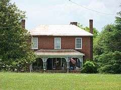
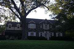
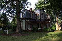
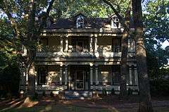
Abraham Anthony Farm |
|
000000001990-05-10-0000May 10, 1990
(#90000738) |
West side of SR 1008, 0.5 miles (0.80 km) south of the junction with SR 2021
35°34′28″N 81°18′38″W / 35.574444°N 81.310556°W / 35.574444; -81.310556 (Abraham Anthony Farm) |
Blackburn |
|
| 2 |
Balls Creek Campground |
|
000000001990-04-27-0000April 27, 1990
(#90000662) |
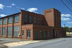
West side of SR 1003, 0.1 miles (0.16 km) south of SR 1943
35°37′46″N 81°05′50″W / 35.629444°N 81.097222°W / 35.629444; -81.097222 (Balls Creek Campground) |
Bandy's Crossroads |
|
| 3 |
Bandy Farms Historic District |
Upload image |
000000001990-04-27-0000April 27, 1990
(#90000663) |
East side of SR 1003, 0.5 miles (0.80 km)-0.85 miles (1.37 km) south of SR 1813 junction
35°37′51″N 81°05′35″W / 35.630833°N 81.093056°W / 35.630833; -81.093056 (Bandy Farms Historic District) |
Bandy's Crossroads |
|
| 4 |
Bolick Historic District |
Upload image |
000000001990-07-05-0000July 5, 1990
(#90001032) |
First Ave. S. between US 64/70 and 12th St.
35°41′49″N 81°13′15″W / 35.696944°N 81.220833°W / 35.696944; -81.220833 (Bolick Historic District) |
Conover |
|
| 5 |
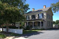
Bost-Burris House |
Upload image |
000000001990-07-05-0000July 5, 1990
(#90001033) |
Junction of SR 1149 and SR 1154
35°40′00″N 81°14′58″W / 35.666667°N 81.249444°W / 35.666667; -81.249444 (Bost-Burris House) |
Newton |
|
| 6 |
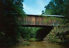
Bunker Hill Covered Bridge |
|
000000001970-02-26-0000February 26, 1970
(#70000446) |
2 miles (3.2 km) east of Claremont on US 70
35°43′20″N 81°06′36″W / 35.722222°N 81.11°W / 35.722222; -81.11 (Bunker Hill Covered Bridge) |
Claremont |
|
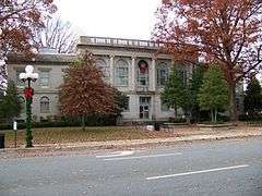
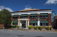
| 7 |
Catawba County Courthouse |
|
000000001979-05-10-0000May 10, 1979
(#79001690) |
S. Main, W.A, S. College, and W. 1st Sts.
35°39′47″N 81°13′19″W / 35.663056°N 81.221944°W / 35.663056; -81.221944 (Catawba County Courthouse) |
Newton |
|
| 8 |
Catawba Historic District |
Upload image |
000000001986-04-28-0000April 28, 1986
(#86000893) |
Roughly bounded by Second Ave. NE, Third and Second Sts. SE, Second Ave. SW and NC 10, and Second St. SW
35°42′26″N 81°04′30″W / 35.707222°N 81.075°W / 35.707222; -81.075 (Catawba Historic District) |
Catawba |
|
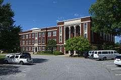
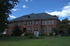
| 9 |
Claremont High School Historic District |
|
000000001986-10-23-0000October 23, 1986
(#86003357) |
Roughly bounded by Fifth and Third Aves., Third St., Second Ave. and N. Center St.; also 505-753 N. Center St., 102-126 and 401 2nd Ave., NE., 406-602 3rd Ave., NE., 12-118 5th Ave., NW., and 212-258 5th Ave.
35°44′08″N 81°20′41″W / 35.735556°N 81.344722°W / 35.735556; -81.344722 (Claremont High School Historic District) |
Hickory |
Second set of boundaries represents a boundary increase of 000000002009-12-18-0000December 18, 2009
|
| 10 |
Elliott-Carnegie Library |
|
000000001985-03-15-0000March 15, 1985
(#85000584) |
415 1st Ave. NW
35°43′58″N 81°20′42″W / 35.732778°N 81.345°W / 35.732778; -81.345 (Elliott-Carnegie Library) |
Hickory |
|
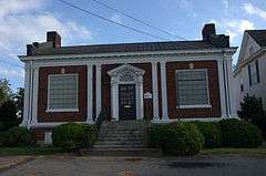
| 11 |
First Presbyterian Church |
|
000000001985-03-15-0000March 15, 1985
(#85000585) |
2nd St. and 3rd Ave. NW
35°44′07″N 81°20′25″W / 35.735278°N 81.340278°W / 35.735278; -81.340278 (First Presbyterian Church) |
Hickory |
|
| 12 |
Foil-Cline House |
Upload image |
000000001990-07-05-0000July 5, 1990
(#90001034) |
406 S. Main Ave.
35°39′29″N 81°13′29″W / 35.658056°N 81.224722°W / 35.658056; -81.224722 (Foil-Cline House) |
Newton |
|
| 13 |
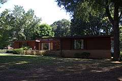
Dr. Glenn R. Frye House |
|
000000002009-08-05-0000August 5, 2009
(#09000600) |
539 N. Center St., NE
35°44′22″N 81°20′17″W / 35.739444°N 81.338056°W / 35.739444; -81.338056 (Dr. Glenn R. Frye House) |
Hickory |
|
| 14 |
Clement Geitner House |
|
000000001985-03-15-0000March 15, 1985
(#85000703) |
436 Main Ave. NW
35°43′57″N 81°20′45″W / 35.7325°N 81.345833°W / 35.7325; -81.345833 (Clement Geitner House) |
Hickory |
|
| 15 |
Lee & Helen George House |
|
000000002012-04-24-0000April 24, 2012
(#12000234) |
16 9th Ave., NE
35°44′41″N 81°20′14″W / 35.744623°N 81.337325°W / 35.744623; -81.337325 (Lee & Helen George House) |
Hickory |
|
| 16 |
Grace Reformed Church |
Upload image |
000000001990-07-05-0000July 5, 1990
(#90001035) |
201-211 S. Main Ave.
35°39′40″N 81°13′23″W / 35.661111°N 81.223056°W / 35.661111; -81.223056 (Grace Reformed Church) |
Newton |
|
| 17 |
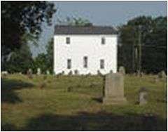
Grace Union Church and Cemetery |
Upload image |
000000001990-05-10-0000May 10, 1990
(#90000739) |
Junction of SR 1008 and SR 2030
35°35′56″N 81°19′02″W / 35.598889°N 81.317222°W / 35.598889; -81.317222 (Grace Union Church and Cemetery) |
Blackburn |
|
| 18 |
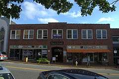
Harris Arcade |
|
000000002008-05-08-0000May 8, 2008
(#08000378) |
221-229 1st Ave. NW.
35°43′59″N 81°20′26″W / 35.733056°N 81.340556°W / 35.733056; -81.340556 (Harris Arcade) |
Hickory |
|
| 19 |
Hickory Municipal Building |
|
000000002000-02-18-0000February 18, 2000
(#00000119) |
30 Third St., SW
35°43′57″N 81°20′32″W / 35.7325°N 81.342222°W / 35.7325; -81.342222 (Hickory Municipal Building) |
Hickory |
|
| 20 |
Hickory Southwest Downtown Historic District |
|
000000002005-12-16-0000December 16, 2005
(#05001409) |
Portions of Government Ave.SE, Second Street Place SE, First Ave. SW and Third St. SW
35°43′51″N 81°20′28″W / 35.730833°N 81.341111°W / 35.730833; -81.341111 (Hickory Southwest Downtown Historic District) |
Hickory |
|
| 21 |
Highland School |
|
000000001990-06-01-0000June 1, 1990
(#90000824) |
1017 10th Ave. NE.
35°44′33″N 81°18′59″W / 35.7425°N 81.316389°W / 35.7425; -81.316389 (Highland School) |
Hickory |
|
| 22 |
Hollar Hosiery Mills-Knit Sox Knitting Mills |
Upload image |
000000002012-12-26-0000December 26, 2012
(#12001087) |
883 Highland Ave., SE
35°44′07″N 81°19′32″W / 35.735409°N 81.325673°W / 35.735409; -81.325673 (Hollar Hosiery Mills-Knit Sox Knitting Mills) |
Hickory |
|
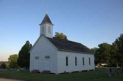
| 23 |
Houck's Chapel |
|
000000001985-03-15-0000March 15, 1985
(#85000587) |
9th Ave. and 17th St. NW
35°44′41″N 81°22′07″W / 35.744722°N 81.368611°W / 35.744722; -81.368611 (Houck's Chapel) |
Hickory |
|
| 24 |
George Huffman Farm |
Upload image |
000000001990-06-21-0000June 21, 1990
(#90000861) |
SR 1479, southeast of the junction with Tate Blvd.
35°42′45″N 81°15′16″W / 35.7125°N 81.254444°W / 35.7125; -81.254444 (George Huffman Farm) |
Conover |
|
| 25 |
Keever-Cansler Farm |
Upload image |
000000001990-05-10-0000May 10, 1990
(#90000740) |
East side of SR 2024, 0.05 miles (0.080 km) north of the junction with SR 2026
35°34′48″N 81°19′33″W / 35.58°N 81.325833°W / 35.58; -81.325833 (Keever-Cansler Farm) |
Blackburn |
|
| 26 |
Kenworth Historic District |
|
000000001985-05-09-0000May 9, 1985
(#85001054) |
Roughly bounded by 2nd Ave., 5th St. and 3rd Ave. Dr. SE; also roughly along 5th St., SE., 5th Ave., SE., 3rd Ave. Dr., SE., and 2nd Ave., SE.
35°43′40″N 81°19′45″W / 35.727778°N 81.329167°W / 35.727778; -81.329167 (Kenworth Historic District) |
Hickory |
Second set of boundaries represents a boundary increase of 000000002005-05-18-0000May 18, 2005
|
| 27 |
John A. Lentz House |
|
000000001985-03-15-0000March 15, 1985
(#85000588) |
321 9th St. NW
35°44′11″N 81°21′09″W / 35.736389°N 81.3525°W / 35.736389; -81.3525 (John A. Lentz House) |
Hickory |
|
| 28 |
Long, McCorkle and Murray Houses |
Upload image |
000000001990-09-05-0000September 5, 1990
(#90001371) |
1310-1326 N. Main Ave.
35°40′35″N 81°13′16″W / 35.676389°N 81.221111°W / 35.676389; -81.221111 (Long, McCorkle and Murray Houses) |
Newton |
|
| 29 |
Lyerly Full Fashioned Mill |
|
000000002007-08-08-0000August 8, 2007
(#06001137) |
56 Third St., SE
35°44′01″N 81°19′59″W / 35.733611°N 81.333056°W / 35.733611; -81.333056 (Lyerly Full Fashioned Mill) |
Hickory |
|
| 30 |
Memorial Reformed Church |
Upload image |
000000001990-06-21-0000June 21, 1990
(#90000865) |
201 E. Main St.
35°34′30″N 81°12′36″W / 35.575°N 81.21°W / 35.575; -81.21 (Memorial Reformed Church) |
Maiden |
|
| 31 |
Miller-Cansler House |
Upload image |
000000001990-05-10-0000May 10, 1990
(#90000741) |
North side of SR 2007, 0.5 miles (0.80 km) east of the junction with SR 1005
35°35′47″N 81°15′14″W / 35.596389°N 81.253889°W / 35.596389; -81.253889 (Miller-Cansler House) |
Maiden |
|
| 32 |
Alexander Moore Farm |
Upload image |
000000001990-04-27-0000April 27, 1990
(#90000664) |
SR 2646 0.5 miles (0.80 km) northwest of SR 1004 junction
35°42′05″N 81°00′02″W / 35.701389°N 81.000556°W / 35.701389; -81.000556 (Alexander Moore Farm) |
Catawba |
|
| 33 |
John Alfred Moretz House |
|
000000001985-03-15-0000March 15, 1985
(#85000589) |
1437 - 6th St. Circle NW
35°45′23″N 81°21′06″W / 35.756389°N 81.351667°W / 35.756389; -81.351667 (John Alfred Moretz House) |
Hickory |
|
| 34 |
Munday House |
Upload image |
000000001975-08-22-0000August 22, 1975
(#75001246) |
Address Restricted
|
Denver |
|
| 35 |
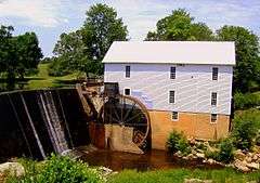
Murray's Mill Historic District |
|
000000001979-12-31-0000December 31, 1979
(#79001689) |
Southeast of Catawba
35°40′27″N 81°05′44″W / 35.674167°N 81.095556°W / 35.674167; -81.095556 (Murray's Mill Historic District) |
Catawba |
|
| 36 |
Neill-Turner-Lester House |
Upload image |
000000001990-05-10-0000May 10, 1990
(#90000742) |
North side of SR 1836, 0.25 miles (0.40 km) northeast of the junction with SR 1837
35°38′59″N 80°57′48″W / 35.649722°N 80.963333°W / 35.649722; -80.963333 (Neill-Turner-Lester House) |
Sherrills Ford |
|
| 37 |
Newton Downtown Historic District |
Upload image |
000000002012-05-01-0000May 1, 2012
(#12000253) |
Roughly bounded by 2nd & A Sts., & N. Forney, & N. Ashe Aves.
35°39′48″N 81°13′17″W / 35.663389°N 81.221325°W / 35.663389; -81.221325 (Newton Downtown Historic District) |
Newton |
|
| 38 |
North Main Avenue Historic District |
Upload image |
000000001986-05-22-0000May 22, 1986
(#86001147) |
Roughly bounded by W. Ninth St., N. Main Ave., W. Fourth and W. Sixth Sts., N. Deal Ave., and W. Eighth St.
35°40′08″N 81°13′26″W / 35.668889°N 81.223889°W / 35.668889; -81.223889 (North Main Avenue Historic District) |
Newton |
|
| 39 |
Oakwood Historic District |
|
000000001986-03-25-0000March 25, 1986
(#86000687) |
Roughly bounded by Oakwood Cemetery and Fourth Ave. NW, Fourth St. NW, Second Ave. NW, and Sixth St. NW
35°44′15″N 81°20′43″W / 35.7375°N 81.345278°W / 35.7375; -81.345278 (Oakwood Historic District) |
Hickory |
|
| 40 |
Perkins House |
Upload image |
000000001974-10-01-0000October 1, 1974
(#74001336) |
North of Catawba off I-40
35°44′00″N 81°04′23″W / 35.733333°N 81.073056°W / 35.733333; -81.073056 (Perkins House) |
Newton |
|
| 41 |
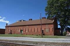
Piedmont Wagon Company |
|
000000001985-03-15-0000March 15, 1985
(#85000592) |
Main Ave. NW
35°43′56″N 81°21′17″W / 35.732222°N 81.354722°W / 35.732222; -81.354722 (Piedmont Wagon Company) |
Hickory |
|
| 42 |
Powell-Trollinger Lime Kilns |
Upload image |
000000001974-11-08-0000November 8, 1974
(#74001337) |
South of Catawba
35°39′11″N 81°03′51″W / 35.653056°N 81.064167°W / 35.653056; -81.064167 (Powell-Trollinger Lime Kilns) |
Catawba |
|
| 43 |
Propst House |
|
000000001973-04-24-0000April 24, 1973
(#73001312) |
Shuford Memorial Garden
35°44′16″N 81°22′45″W / 35.737778°N 81.379167°W / 35.737778; -81.379167 (Propst House) |
Hickory |
|
| 44 |
David F. Propst House |
Upload image |
000000001990-06-21-0000June 21, 1990
(#90000864) |
Junction of SR 1810 and SR 1878
35°35′51″N 81°11′08″W / 35.5975°N 81.185556°W / 35.5975; -81.185556 (David F. Propst House) |
Maiden |
|
| 45 |
Franklin D. Reinhardt and Harren-Hood Farms |
Upload image |
000000001990-06-21-0000June 21, 1990
(#90000863) |
SR 2013 northwest of the junction with SR 2012
35°37′05″N 81°14′21″W / 35.618056°N 81.239167°W / 35.618056; -81.239167 (Franklin D. Reinhardt and Harren-Hood Farms) |
Maiden |
|
| 46 |
William Pinckney Reinhardt House |
Upload image |
000000001990-07-19-0000July 19, 1990
(#90001111) |
Junction of SR 2012 and SR 2013
35°36′20″N 81°14′15″W / 35.605556°N 81.2375°W / 35.605556; -81.2375 (William Pinckney Reinhardt House) |
Maiden |
|
| 47 |
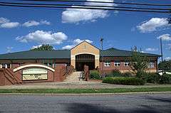
Ridgeview Public Library, (Former) |
Upload image |
000000002011-05-12-0000May 12, 2011
(#11000294) |
415 1st St., S.W.
35°43′37″N 81°20′20″W / 35.726944°N 81.338889°W / 35.726944; -81.338889 (Ridgeview Public Library, (Former)) |
Hickory |
|
| 48 |
Rock Barn Farm |
Upload image |
000000001990-07-05-0000July 5, 1990
(#90001036) |
West side of SR 1709, 0.4 miles (0.64 km) north of the junction with SR 1715
35°44′32″N 81°09′39″W / 35.742222°N 81.160833°W / 35.742222; -81.160833 (Rock Barn Farm) |
Claremont |
|
| 49 |
Rudisill-Wilson House |
Upload image |
000000001973-08-14-0000August 14, 1973
(#73001315) |
Southwest of Newton off NC 10
35°36′58″N 81°15′23″W / 35.616111°N 81.256389°W / 35.616111; -81.256389 (Rudisill-Wilson House) |
Newton |
|
| 50 |
Self-Trott-Bickett House |
Upload image |
000000001990-07-05-0000July 5, 1990
(#90001037) |
331 S. College Ave.
35°39′32″N 81°13′22″W / 35.658889°N 81.222778°W / 35.658889; -81.222778 (Self-Trott-Bickett House) |
Newton |
|
| 51 |
Sharpe-Gentry Farm |
Upload image |
000000001990-06-21-0000June 21, 1990
(#90000859) |
Junction of NC 10 and SR 1137
35°37′41″N 81°22′22″W / 35.628056°N 81.372778°W / 35.628056; -81.372778 (Sharpe-Gentry Farm) |
Propst Crossroads |
|
| 52 |
Miles Alexander Sherrill House |
Upload image |
000000001990-04-27-0000April 27, 1990
(#90000665) |
West side of SR 1849, 0.1 miles (0.16 km) south of SR 1848 junction
35°37′37″N 81°00′28″W / 35.626944°N 81.007778°W / 35.626944; -81.007778 (Miles Alexander Sherrill House) |
Sherrills Ford |
|
| 53 |
Shuford House |
|
000000001973-04-24-0000April 24, 1973
(#73001313) |
542 2nd St. NE.
35°44′26″N 81°20′00″W / 35.740556°N 81.333333°W / 35.740556; -81.333333 (Shuford House) |
Hickory |
|
| 54 |
Shuford-Hoover House |
Upload image |
000000001990-05-10-0000May 10, 1990
(#90000743) |
East side of SR 1008, 0.05 miles (0.080 km) south of the junction with SR 10
35°37′24″N 81°19′16″W / 35.623333°N 81.321111°W / 35.623333; -81.321111 (Shuford-Hoover House) |
Blackburn |
|
| 55 |
St. Paul's Church and Cemetery |
|
000000001971-12-09-0000December 9, 1971
(#71000573) |
Junction of SR 1149 and SR 1164
35°40′35″N 81°14′38″W / 35.676389°N 81.243889°W / 35.676389; -81.243889 (St. Paul's Church and Cemetery) |
Newton |
|
| 56 |
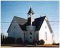
St. Paul's Reformed Church |
|
000000001990-06-21-0000June 21, 1990
(#90000860) |
Junction of SR 1151 and SR 1005
35°38′52″N 81°16′05″W / 35.647778°N 81.268056°W / 35.647778; -81.268056 (St. Paul's Reformed Church) |
Startown |
|
| 57 |
Terrell Historic District |
Upload image |
000000001986-07-15-0000July 15, 1986
(#86001685) |
NC 150 and SR 1848
35°33′34″N 80°58′38″W / 35.559444°N 80.977222°W / 35.559444; -80.977222 (Terrell Historic District) |
Terrell |
|
| 58 |
Warlick-Huffman Farm |
Upload image |
000000001990-06-21-0000June 21, 1990
(#90000862) |
SR 1116 northwest of the junction with NC 10
35°37′04″N 81°24′48″W / 35.617778°N 81.413333°W / 35.617778; -81.413333 (Warlick-Huffman Farm) |
Propst Crossroads |
|
| 59 |
Weidner Rock House |
Upload image |
000000001973-12-04-0000December 4, 1973
(#73001314) |
South of Hickory on SR 1142
35°38′42″N 81°18′35″W / 35.645°N 81.309722°W / 35.645; -81.309722 (Weidner Rock House) |
Hickory |
|
| 60 |
Wesley's Chapel Arbor and Cemetery |
Upload image |
000000001990-05-10-0000May 10, 1990
(#90000744) |
West side of SR 2033, 0.4 miles (0.64 km) south of the junction with SR 10
35°36′55″N 81°20′55″W / 35.615278°N 81.348611°W / 35.615278; -81.348611 (Wesley's Chapel Arbor and Cemetery) |
Blackburn |
|
| 61 |
Whisnant Hosiery Mills |
Upload image |
000000002013-08-27-0000August 27, 2013
(#13000637) |
74 8th St., SE.
35°43′59″N 81°19′37″W / 35.733101°N 81.327024°W / 35.733101; -81.327024 (Whisnant Hosiery Mills) |
Hickory |
|
| 62 |
Wilfong-Wilson Farm |
Upload image |
000000001990-06-21-0000June 21, 1990
(#90000858) |
SR 1145, southwest of the junction with SR 1146
35°38′41″N 81°17′40″W / 35.644722°N 81.294444°W / 35.644722; -81.294444 (Wilfong-Wilson Farm) |
Startown |
|
| 63 |
Yoder's Mills Historic District |
Upload image |
000000001980-01-11-0000January 11, 1980
(#80002806) |
Address Restricted
|
Hickory |
|