| [3] |
Name on the Register[4] |
Image |
Date listed[5] |
Location |
City or town |
Description |
|---|
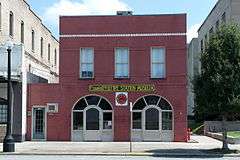
| 1 |
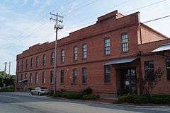
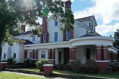
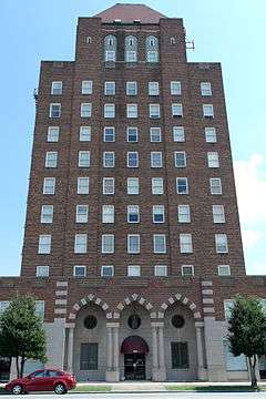
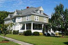
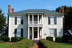
American Tobacco Company Prizery |
|
000000002005-04-28-0000April 28, 2005
(#05000350) |
619 North Herritage Street
35°16′09″N 77°34′57″W / 35.269167°N 77.5825°W / 35.269167; -77.5825 (American Tobacco Company Prizery) |
Kinston |
|
| 2 |
Atlantic and North Carolina Railroad Freight Depot |
|
000000001989-11-08-0000November 8, 1989
(#89001768) |
East Blount Street between North Queen and North McLewean Streets
35°15′47″N 77°34′49″W / 35.263056°N 77.580278°W / 35.263056; -77.580278 (Atlantic and North Carolina Railroad Freight Depot) |
Kinston |
|
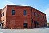
| 3 |
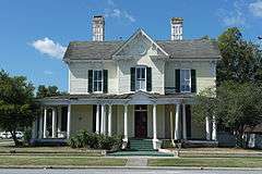
Baptist Parsonage |
|
000000001989-11-08-0000November 8, 1989
(#89001767) |
211 South McLewean Street
35°15′28″N 77°34′48″W / 35.257778°N 77.58°W / 35.257778; -77.58 (Baptist Parsonage) |
Kinston |
|
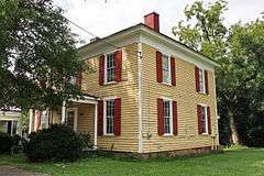
| 4 |
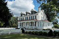
Robert L. Blalock House |
|
000000001989-11-08-0000November 8, 1989
(#89001772) |
300 South McLewean Street
35°15′25″N 77°34′47″W / 35.256944°N 77.579722°W / 35.256944; -77.579722 (Robert L. Blalock House) |
Kinston |
|
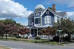
| 5 |
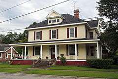
B. W. Canady House |
|
000000001989-11-08-0000November 8, 1989
(#89001771) |
600 North Queen Street
35°15′59″N 77°34′54″W / 35.266389°N 77.581667°W / 35.266389; -77.581667 (B. W. Canady House) |
Kinston |
|
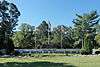
| 6 |
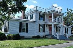
Cedar Dell |
|
000000001971-08-26-0000August 26, 1971
(#71000600) |
Southeast of Falling Creek on SR 1338
35°15′17″N 77°41′20″W / 35.254722°N 77.688889°W / 35.254722; -77.688889 (Cedar Dell) |
Falling Creek |
|
| 7 |
CSS NEUSE (Ironclad Gunboat) |
Upload image |
000000002001-06-11-0000June 11, 2001
(#00000444) |
2612 West Vernon Avenue
35°16′01″N 77°37′18″W / 35.266944°N 77.621667°W / 35.266944; -77.621667 (CSS NEUSE (Ironclad Gunboat)) |
Kinston |
|
| 8 |
Herring House |
Upload image |
000000001973-10-25-0000October 25, 1973
(#73001356) |
Northwest of La Grange off SR 1503
35°19′44″N 77°48′22″W / 35.328889°N 77.806111°W / 35.328889; -77.806111 (Herring House) |
La Grange |
|
| 9 |
Hill-Grainger Historic District |
|
000000001989-11-08-0000November 8, 1989
(#89001764) |
Roughly bounded by Summit Avenue, North East Street, East and West Vernon Avenue, and North Heritage Street
35°16′17″N 77°34′47″W / 35.271389°N 77.579722°W / 35.271389; -77.579722 (Hill-Grainger Historic District) |
Kinston |
|
| 10 |
Hotel Kinston |
|
000000001989-11-08-0000November 8, 1989
(#89001770) |
503 North Queen Street
35°15′54″N 77°34′52″W / 35.265°N 77.581111°W / 35.265; -77.581111 (Hotel Kinston) |
Kinston |
|
| 11 |
Jesse Jackson House |
Upload image |
000000001971-06-24-0000June 24, 1971
(#71000602) |
Southeast of Kinston on NC 11
35°13′33″N 77°38′40″W / 35.225936°N 77.644356°W / 35.225936; -77.644356 (Jesse Jackson House) |
Kinston |
|
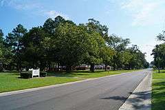
| 12 |
Kennedy Memorial Home Historic District |
|
000000002009-09-03-0000September 3, 2009
(#09000684) |
2557 Ceder Dell Lane
35°15′17″N 77°41′33″W / 35.254722°N 77.6925°W / 35.254722; -77.6925 (Kennedy Memorial Home Historic District) |
Kinston |
|
| 13 |
Kinston Apartments |
Upload image |
000000002004-06-22-0000June 22, 2004
(#04000648) |
1313 McAdoo Street
35°16′40″N 77°34′42″W / 35.277778°N 77.578333°W / 35.277778; -77.578333 (Kinston Apartments) |
Kinston |
|
| 14 |
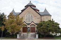
Kinston Baptist-White Rock Presbyterian Church |
|
000000001989-11-08-0000November 8, 1989
(#89001773) |
516 Thompson Street
35°15′54″N 77°34′22″W / 35.265°N 77.572778°W / 35.265; -77.572778 (Kinston Baptist-White Rock Presbyterian Church) |
Kinston |
|
| 15 |
Kinston Battlefield |
|
000000002006-11-30-0000November 30, 2006
(#06001104) |
1.5 miles (2.4 km) south of Kinston on US 258; 2 to 3 miles (3.2 to 4.8 km) south of Kinston on US 258; 3 miles (4.8 km) south of Kinston on NC 58; 4 miles (6.4 km) south of Kinston on US 258
35°13′41″N 77°36′36″W / 35.228056°N 77.61°W / 35.228056; -77.61 (Kinston Battlefield) |
Kinston |
|
| 16 |
Kinston Commercial Historic District |
Upload image |
000000001994-06-03-0000June 3, 1994
(#94000569) |
Roughly bounded by E. Blount, W. Blount, N. Herritage, W. North and N. Queen Sts.
35°15′46″N 77°34′50″W / 35.2627226°N 77.5805034°W / 35.2627226; -77.5805034 (Kinston Commercial Historic District) |
Kinston |
|
| 17 |
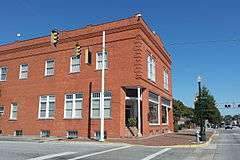
Kinston Fire Station-City Hall |
|
000000001989-11-08-0000November 8, 1989
(#89001769) |
118 South Queen Street
35°15′34″N 77°34′53″W / 35.259444°N 77.581389°W / 35.259444; -77.581389 (Kinston Fire Station-City Hall) |
Kinston |
|
| 18 |
LaGrange Historic District |
|
000000002000-05-11-0000May 11, 2000
(#00000458) |
Roughly bounded by North Caswell, East James, North Carey, East Washington, South Caswell, West Washington, and Forbes Streets
35°18′20″N 77°47′30″W / 35.305556°N 77.791667°W / 35.305556; -77.791667 (LaGrange Historic District) |
La Grange |
|
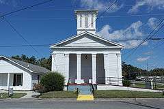
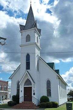
| 19 |
LaGrange Presbyterian Church |
|
000000001986-08-14-0000August 14, 1986
(#86001646) |
201 South Caswell Street
35°18′17″N 77°47′21″W / 35.304722°N 77.789167°W / 35.304722; -77.789167 (LaGrange Presbyterian Church) |
La Grange |
|
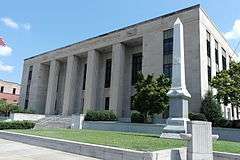
| 20 |
Lenoir County Courthouse |
|
000000001979-05-10-0000May 10, 1979
(#79001730) |
Queen and Kings Streets
35°15′30″N 77°34′25″W / 35.258333°N 77.573611°W / 35.258333; -77.573611 (Lenoir County Courthouse) |
Kinston |
|
| 21 |
Mitchelltown Historic District |
|
000000001989-11-08-0000November 8, 1989
(#89001766) |
Roughly bounded by West Vernon Avenue, North Heritage Street, West Blount Street, College Street, Atlantic Avenue, and Rhem Street
35°15′58″N 77°35′13″W / 35.266111°N 77.586944°W / 35.266111; -77.586944 (Mitchelltown Historic District) |
Kinston |
|
| 22 |
Peebles House |
|
000000001971-08-26-0000August 26, 1971
(#71000603) |
109 East King Street
35°15′33″N 77°34′59″W / 35.259167°N 77.583056°W / 35.259167; -77.583056 (Peebles House) |
Kinston |
|
| 23 |
Peoples Bank Building |
Upload image |
000000001998-11-08-0000November 8, 1998
(#89001774) |
242 S. Queen Street
35°15′27″N 77°34′51″W / 35.257553°N 77.580957°W / 35.257553; -77.580957 (Peoples Bank Building) |
Kinston |
|
| 24 |
Queen-Gordon Streets Historic District |
|
000000001989-11-08-0000November 8, 1989
(#89001765) |
Roughly N. Queen and Gordon Sts.; also roughly bounded by E. Blount, W. Blount, N. Heritage, W. North, and N. Queen Sts.
35°15′43″N 77°34′52″W / 35.261944°N 77.581111°W / 35.261944; -77.581111 (Queen-Gordon Streets Historic District) |
Kinston |
Second set of boundaries represents a boundary increase of 000000001994-06-03-0000June 3, 1994, the Kinston Commercial Historic District
|
| 25 |
Standard Drug No. 2 |
Upload image |
000000002014-12-01-0000December 1, 2014
(#14000987) |
100 South Queen Street
35°15′36″N 77°34′52″W / 35.2601°N 77.5811°W / 35.2601; -77.5811 (Standard Drug No. 2) |
Kinston |
|
| 26 |
Sumrell and McCoy Building |
|
000000001989-12-21-0000December 21, 1989
(#89002134) |
400 North Queen Street
35°15′49″N 77°34′54″W / 35.263611°N 77.581667°W / 35.263611; -77.581667 (Sumrell and McCoy Building) |
Kinston |
|
| 27 |
Trianon Historic District |
Upload image |
000000001989-11-08-0000November 8, 1989
(#89001763) |
Roughly East Gordon Street from North Tiffany to North Orion Streets and Water Street from North Vance to North Orion Streets
35°15′40″N 77°34′15″W / 35.261111°N 77.570833°W / 35.261111; -77.570833 (Trianon Historic District) |
Kinston |
|
| 28 |
Tull-Worth-Holland Farm |
Upload image |
000000001992-09-22-0000September 22, 1992
(#92001260) |
NC 1579 north side, 0.5 miles (0.80 km) east of junction with NC 1578
35°18′54″N 77°35′30″W / 35.315°N 77.591667°W / 35.315; -77.591667 (Tull-Worth-Holland Farm) |
Kinston |
|
| 29 |
Dempsey Wood House |
|
000000001971-08-26-0000August 26, 1971
(#71000601) |
Southwest of Falling Creek on SR 1324
35°13′51″N 77°43′28″W / 35.230833°N 77.724444°W / 35.230833; -77.724444 (Dempsey Wood House) |
Kinston |
|