| [3] |
Name on the Register[4] |
Image |
Date listed[5] |
Location |
City or town |
Description |
|---|
| 1 |
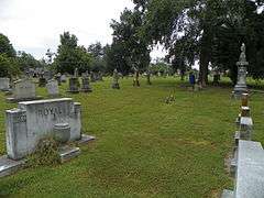
Abbott's Creek Primitive Baptist Church Cemetery |
Upload image |
000000001984-07-10-0000July 10, 1984
(#84001982) |
SR 1743
36°00′20″N 80°05′01″W / 36.005556°N 80.083611°W / 36.005556; -80.083611 (Abbott's Creek Primitive Baptist Church Cemetery) |
Thomasville |
part of the Anglo-German Cemeteries Thematic Resource (TR)
|
| 2 |
Adderton - Badgett House |
Upload image |
000000001984-07-10-0000July 10, 1984
(#84001988) |
SR 2529
35°34′02″N 80°08′36″W / 35.567222°N 80.143333°W / 35.567222; -80.143333 (Adderton - Badgett House) |
Denton |
part of the Davidson County Multiple Resource Area (MRA)
|
| 3 |
Beallmont |
Upload image |
000000001984-07-10-0000July 10, 1984
(#84001991) |
SR 1133
35°44′51″N 80°20′23″W / 35.7475°N 80.339722°W / 35.7475; -80.339722 (Beallmont) |
Linwood |
part of the Davidson County MRA
|
| 4 |
Beck's Reformed Church Cemetery |
Upload image |
000000001984-07-10-0000July 10, 1984
(#84001992) |
SR 2250
35°45′29″N 80°13′33″W / 35.758056°N 80.225833°W / 35.758056; -80.225833 (Beck's Reformed Church Cemetery) |
Silver Hill |
part of the Anglo-German Cemeteries TR
|
| 5 |
Bethany Reformed and Lutheran Church Cemetery |
Upload image |
000000001984-07-10-0000July 10, 1984
(#84001994) |
SR 1716
35°50′34″N 80°06′56″W / 35.842778°N 80.115556°W / 35.842778; -80.115556 (Bethany Reformed and Lutheran Church Cemetery) |
Midway |
part of the Anglo-German Cemeteries TR
|
| 6 |
Beulah Church of Christ Cemetery |
Upload image |
000000001984-07-10-0000July 10, 1984
(#84001995) |
SR 1457
35°53′17″N 80°16′43″W / 35.888056°N 80.278611°W / 35.888056; -80.278611 (Beulah Church of Christ Cemetery) |
Welcome |
part of the Anglo-German Cemeteries TR
|
| 7 |
Brummell's Inn |
Upload image |
000000001980-11-25-0000November 25, 1980
(#80002822) |
North of Thomasville
35°56′55″N 80°06′17″W / 35.948611°N 80.104722°W / 35.948611; -80.104722 (Brummell's Inn) |
Thomasville |
|
| 8 |
Chapel Hill Church Tabernacle |
Upload image |
000000002012-04-24-0000April 24, 2012
(#12000235) |
1457 Chapel Hill Church Rd.
35°33′13″N 80°04′16″W / 35.553571°N 80.071151°W / 35.553571; -80.071151 (Chapel Hill Church Tabernacle) |
Denton vicinity |
|
| 9 |
Church Street School |
|
000000001990-03-01-0000March 1, 1990
(#90000355) |
Jasper St., West of Church St.
35°53′21″N 80°05′21″W / 35.889167°N 80.089167°W / 35.889167; -80.089167 (Church Street School) |
Thomasville |
|
| 10 |
Emanuel United Church of Christ Cemetery |
Upload image |
000000001984-07-10-0000July 10, 1984
(#84001997) |
SR 2060
35°50′34″N 80°06′56″W / 35.842778°N 80.115556°W / 35.842778; -80.115556 (Emanuel United Church of Christ Cemetery) |
Thomasville |
part of the Anglo-German Cemeteries TR
|
| 11 |
Erlanger Mill Village Historic District |
Upload image |
000000002008-01-09-0000January 9, 2008
(#07001371) |
Roughly bounded by Winston Rd., Short, 7th, Hames, Second Rainbow, Park Circle, & Olympia Sts.
35°50′23″N 80°15′20″W / 35.839714°N 80.255539°W / 35.839714; -80.255539 (Erlanger Mill Village Historic District) |
Lexington |
|
| 12 |
Hamilton Everhart Farm |
Upload image |
000000001984-07-10-0000July 10, 1984
(#84002000) |
US 52
35°55′46″N 80°13′31″W / 35.929444°N 80.225278°W / 35.929444; -80.225278 (Hamilton Everhart Farm) |
Midway |
part of the Davidson County MRA
|
| 13 |
Riley Everhart Farm and General Store |
Upload image |
000000001984-07-10-0000July 10, 1984
(#84002001) |
SR 1468
35°53′30″N 80°16′28″W / 35.891667°N 80.274444°W / 35.891667; -80.274444 (Riley Everhart Farm and General Store) |
Arnold |
part of the Davidson County MRA
|
| 14 |
Fair Grove Methodist Church Cemetery |
|
000000001984-07-10-0000July 10, 1984
(#84002004) |
NC 109, SR 2072 and 2070
35°51′05″N 80°04′42″W / 35.851389°N 80.078333°W / 35.851389; -80.078333 (Fair Grove Methodist Church Cemetery) |
South Thomasville |
part of the Anglo-German Cemeteries TR
|
| 15 |
First Reformed Church |
Upload image |
000000002000-04-28-0000April 28, 2000
(#00000417) |
22 E. Center S.
35°49′25″N 80°15′08″W / 35.823611°N 80.252222°W / 35.823611; -80.252222 (First Reformed Church) |
Lexington |
|
| 16 |
Good Hope Methodist Church Cemetery |
Upload image |
000000001984-07-10-0000July 10, 1984
(#84002007) |
Junction of NC 150 and SR 1445
35°55′45″N 80°20′11″W / 35.929167°N 80.336389°W / 35.929167; -80.336389 (Good Hope Methodist Church Cemetery) |
Welcome |
part of the Anglo-German Cemeteries TR
|
| 17 |
Grace Episcopal Church |
Upload image |
000000002006-12-20-0000December 20, 2006
(#06001138) |
419 S. Main St.
35°49′13″N 80°15′26″W / 35.820278°N 80.257222°W / 35.820278; -80.257222 (Grace Episcopal Church) |
Lexington |
|
| 18 |
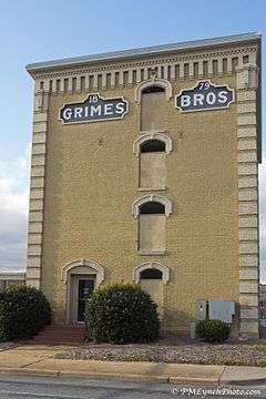
Grimes Brothers Mill |
|
000000002002-05-02-0000May 2, 2002
(#02000443) |
2 North State St.
35°49′31″N 80°15′17″W / 35.825278°N 80.254722°W / 35.825278; -80.254722 (Grimes Brothers Mill) |
Lexington |
|
| 19 |
Grimes School |
Upload image |
000000001988-12-28-0000December 28, 1988
(#88002832) |
Hege Dr.
35°50′00″N 80°15′22″W / 35.833333°N 80.256111°W / 35.833333; -80.256111 (Grimes School) |
Lexington |
|
| 20 |
Grimes-Crotts Mill |
Upload image |
000000001984-07-10-0000July 10, 1984
(#84002008) |
SR 1445
35°55′13″N 80°22′15″W / 35.920278°N 80.370833°W / 35.920278; -80.370833 (Grimes-Crotts Mill) |
Reedy Creek |
part of the Davidson County MRA
|
| 21 |
Haden Place |
Upload image |
000000001984-07-10-0000July 10, 1984
(#84002009) |
SR 1156
35°45′56″N 80°21′34″W / 35.765556°N 80.359444°W / 35.765556; -80.359444 (Haden Place) |
Tyro |
part of the Davidson County MRA
|
| 22 |
Hampton House |
Upload image |
000000001984-07-10-0000July 10, 1984
(#84002025) |
SR 483
35°56′47″N 80°22′17″W / 35.946389°N 80.371389°W / 35.946389; -80.371389 (Hampton House) |
Arcadia |
part of the Davidson County MRA
|
| 23 |
Hedrick's Grove Reformed Church |
Upload image |
000000002008-01-31-0000January 31, 2008
(#07001496) |
3840 Allred Rd.
35°46′18″N 80°10′48″W / 35.771667°N 80.18°W / 35.771667; -80.18 (Hedrick's Grove Reformed Church) |
Lexington |
|
| 24 |
Dr. William Rainey Holt House |
Upload image |
000000001983-06-23-0000June 23, 1983
(#83001876) |
408 S. Main St.
35°49′15″N 80°15′27″W / 35.820833°N 80.2575°W / 35.820833; -80.2575 (Dr. William Rainey Holt House) |
Lexington |
|
| 25 |
Jersey Baptist Church Cemetery |
Upload image |
000000001984-07-10-0000July 10, 1984
(#84002027) |
SR 1272
35°43′57″N 80°18′43″W / 35.7325°N 80.311944°W / 35.7325; -80.311944 (Jersey Baptist Church Cemetery) |
Linwood |
part of the Anglo-German Cemeteries TR
|
| 26 |
Jersey Settlement Meeting House |
Upload image |
000000001984-07-10-0000July 10, 1984
(#84002032) |
SR 1272
35°43′55″N 80°18′42″W / 35.731944°N 80.311667°W / 35.731944; -80.311667 (Jersey Settlement Meeting House) |
Linwood |
part of the Davidson County MRA
|
| 27 |
Junior Order United American Mechanics National Orphans Home |
Upload image |
000000001984-07-10-0000July 10, 1984
(#84002034) |
NC 8
35°45′49″N 80°16′38″W / 35.763611°N 80.277222°W / 35.763611; -80.277222 (Junior Order United American Mechanics National Orphans Home) |
Lexington |
part of the Davidson County MRA
|
| 28 |
Capt. John Koonts, Jr., Farm |
Upload image |
000000001984-07-10-0000July 10, 1984
(#84002131) |
SR 1186
35°50′43″N 80°22′59″W / 35.845278°N 80.383056°W / 35.845278; -80.383056 (Capt. John Koonts, Jr., Farm) |
Tyro |
part of the Davidson County MRA
|
| 29 |
Shadrach Lambeth House |
Upload image |
000000001984-07-10-0000July 10, 1984
(#84002135) |
SR 2062
35°51′24″N 80°03′19″W / 35.856667°N 80.055278°W / 35.856667; -80.055278 (Shadrach Lambeth House) |
Thomasville |
part of the Davidson County MRA
|
| 30 |
Lexington Memorial Hospital |
Upload image |
000000002012-05-24-0000May 24, 2012
(#12000313) |
111 North Carolina Ave.
35°48′35″N 80°14′53″W / 35.809861°N 80.247964°W / 35.809861; -80.247964 (Lexington Memorial Hospital) |
Lexington |
|
| 31 |
Lexington Residential Historic District |
Upload image |
000000002007-04-19-0000April 19, 2007
(#07000350) |
Roughly bounded by State St., W. Fifth St., Martin St., Westside Dr., Southbound St., and W. Ninth Ave.
35°49′34″N 80°15′34″W / 35.826006°N 80.259467°W / 35.826006; -80.259467 (Lexington Residential Historic District) |
Lexington |
|
| 32 |
Mitchell House |
|
000000002000-09-20-0000September 20, 2000
(#00001121) |
411 Biggs Ave.
35°52′39″N 80°05′38″W / 35.8775°N 80.093889°W / 35.8775; -80.093889 (Mitchell House) |
Thomasville |
|
| 33 |
Eli Moore House |
Upload image |
000000001984-07-10-0000July 10, 1984
(#84002137) |
SR 1741
35°58′52″N 80°03′41″W / 35.981111°N 80.061389°W / 35.981111; -80.061389 (Eli Moore House) |
High Point |
part of the Davidson County MRA
|
| 34 |
Mor-Val Hosiery Mill |
Upload image |
000000002001-10-05-0000October 5, 2001
(#01001074) |
N. Main and E. First Sts.
35°38′04″N 80°06′49″W / 35.634444°N 80.113611°W / 35.634444; -80.113611 (Mor-Val Hosiery Mill) |
Denton |
|
| 35 |
Mount Ebal Methodist Protestant Church |
Upload image |
000000001984-07-10-0000July 10, 1984
(#84002143) |
End of SR 2518
35°37′34″N 80°04′05″W / 35.626111°N 80.068056°W / 35.626111; -80.068056 (Mount Ebal Methodist Protestant Church) |
Denton |
part of the Davidson County MRA
|
| 36 |
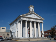
Old Davidson County Courthouse |
|
000000001971-06-24-0000June 24, 1971
(#71000576) |
Main and Center Sts.
35°49′30″N 80°15′13″W / 35.825°N 80.253611°W / 35.825; -80.253611 (Old Davidson County Courthouse) |
Lexington |
|
| 37 |
Pilgrim Reformed Church Cemetery |
Upload image |
000000001984-07-10-0000July 10, 1984
(#84002145) |
SR 1843
35°51′10″N 80°13′03″W / 35.852778°N 80.2175°W / 35.852778; -80.2175 (Pilgrim Reformed Church Cemetery) |
Lexington |
part of the Anglo-German Cemeteries TR
|
| 38 |
Randolph Street Historic District |
Upload image |
000000002012-08-28-0000August 28, 2012
(#12000571) |
100-200 blocks of Randolph St., & 10 W. Colonial Dr.
35°52′48″N 80°04′51″W / 35.879871°N 80.080871°W / 35.879871; -80.080871 (Randolph Street Historic District) |
Thomasville |
|
| 39 |
Reid Farm |
Upload image |
000000001979-01-25-0000January 25, 1979
(#79001700) |
West of Jackson Hill on SR 2537
35°34′10″N 80°11′58″W / 35.569444°N 80.199444°W / 35.569444; -80.199444 (Reid Farm) |
Jackson Hill |
|
| 40 |
Salem Street Historic District |
Upload image |
000000002006-08-09-0000August 9, 2006
(#06000688) |
108-301 Salem St., 6-12 Forsyth St., and 6 Leonard St.
35°53′19″N 80°05′02″W / 35.888611°N 80.083889°W / 35.888611; -80.083889 (Salem Street Historic District) |
Thomasville |
|
| 41 |
Henry Shoaf Farm |
Upload image |
000000001984-07-13-0000July 13, 1984
(#84002148) |
NC 64
35°50′07″N 80°16′49″W / 35.835278°N 80.280278°W / 35.835278; -80.280278 (Henry Shoaf Farm) |
Lexington |
part of the Davidson County MRA
|
| 42 |
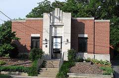
Smith Clinic |
|
000000001991-11-29-0000November 29, 1991
(#91001746) |
17 Randolph St.
35°52′54″N 80°04′51″W / 35.881667°N 80.080833°W / 35.881667; -80.080833 (Smith Clinic) |
Thomasville |
|
| 43 |
Philip Sowers House |
Upload image |
000000001980-11-25-0000November 25, 1980
(#80002821) |
SR 1162
35°47′30″N 80°27′40″W / 35.791667°N 80.461111°W / 35.791667; -80.461111 (Philip Sowers House) |
Churchland |
|
| 44 |
Adam Spach Rock House Site |
|
000000002002-06-14-0000June 14, 2002
(#02000643) |
Address Restricted
|
Winston-Salem |
|
| 45 |
Spring Hill Methodist Protestant Church Cemetery |
Upload image |
000000001984-07-10-0000July 10, 1984
(#84002151) |
SR 1755
35°58′15″N 80°03′20″W / 35.970833°N 80.055556°W / 35.970833; -80.055556 (Spring Hill Methodist Protestant Church Cemetery) |
High Point |
part of the Anglo-German Cemeteries TR
|
| 46 |
Spurgeon House |
Upload image |
000000001983-04-20-0000April 20, 1983
(#83001877) |
West of High Point
35°59′15″N 80°05′19″W / 35.9875°N 80.088611°W / 35.9875; -80.088611 (Spurgeon House) |
High Point |
|
| 47 |
St. Luke's Lutheran Church Cemetery |
Upload image |
000000001984-07-10-0000July 10, 1984
(#84002147) |
SR 1183
35°49′00″N 80°22′32″W / 35.816667°N 80.375556°W / 35.816667; -80.375556 (St. Luke's Lutheran Church Cemetery) |
Tyro |
part of the Anglo-German Cemeteries TR
|
| 48 |
Thomasville Downtown Historic District |
Upload image |
000000002005-09-01-0000September 1, 2005
(#05000940) |
Roughly bounded by Main St., Trade St., Guilford St. and Commerce St.
35°53′01″N 80°05′02″W / 35.883561°N 80.0838°W / 35.883561; -80.0838 (Thomasville Downtown Historic District) |
Thomasville |
|
| 49 |
Thomasville Railroad Passenger Depot |
Upload image |
000000001981-07-09-0000July 9, 1981
(#81000423) |
W. Main St.
35°52′56″N 80°05′02″W / 35.882222°N 80.083889°W / 35.882222; -80.083889 (Thomasville Railroad Passenger Depot) |
Thomasville |
|
| 50 |
Tyro Tavern |
Upload image |
000000001984-08-16-0000August 16, 1984
(#84002154) |
NC 150
35°48′23″N 80°22′37″W / 35.806389°N 80.376944°W / 35.806389; -80.376944 (Tyro Tavern) |
Tyro |
part of the Davidson County MRA
|
| 51 |
Uptown Lexington Historic District |
Upload image |
000000001996-05-16-0000May 16, 1996
(#96000570) |
Main St. from 3rd Ave. to 2nd St.
35°49′24″N 80°15′15″W / 35.823333°N 80.254167°W / 35.823333; -80.254167 (Uptown Lexington Historic District) |
Lexington |
|
| 52 |
Waggoner Graveyard |
Upload image |
000000001984-07-10-0000July 10, 1984
(#84002158) |
SR 1814
35°55′21″N 80°11′46″W / 35.9225°N 80.196111°W / 35.9225; -80.196111 (Waggoner Graveyard) |
Welcome |
part of the Anglo-German Cemeteries TR
|
| 53 |
George W. Wall House |
Upload image |
000000001984-07-10-0000July 10, 1984
(#84002161) |
NC 109 and SR 1723
36°00′35″N 80°08′31″W / 36.009722°N 80.141944°W / 36.009722; -80.141944 (George W. Wall House) |
Wallburg |
part of the Davidson County MRA
|
| 54 |
John Henry Welborn House |
Upload image |
000000001984-07-10-0000July 10, 1984
(#84002163) |
511 S. Main St.
35°49′09″N 80°15′29″W / 35.819167°N 80.258056°W / 35.819167; -80.258056 (John Henry Welborn House) |
Lexington |
Destroyed 1990;[6] part of the Davidson County MRA
|
| 55 |
Yadkin College Historic District |
Upload image |
000000001988-02-25-0000February 25, 1988
(#88000165) |
North and south sides of SR 1194 west of SR 1436
35°52′32″N 80°22′56″W / 35.875556°N 80.382222°W / 35.875556; -80.382222 (Yadkin College Historic District) |
Yadkin College |
part of the Davidson County MRA |