| [3] |
Name on the Register[4] |
Image |
Date listed[5] |
Location |
City or town |
Description |
|---|
| 1 |
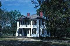
Atkinson-Smith House |
Upload image |
000000001975-06-05-0000June 5, 1975
(#75001276) |
10 miles (16 km) east of Smithfield off SR 1007
35°42′50″N 78°14′17″W / 35.713889°N 78.238056°W / 35.713889; -78.238056 (Atkinson-Smith House) |
Smithfield |
|
| 2 |
Benson Historic District |
Upload image |
000000001985-05-09-0000May 9, 1985
(#85001053) |
Roughly bounded by E. Hill, N. Lee, E. Parish and Farmers Dr. on Main and Church Sts.
35°22′54″N 78°32′51″W / 35.381667°N 78.5475°W / 35.381667; -78.5475 (Benson Historic District) |
Benson |
|
| 3 |
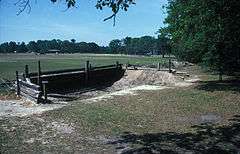
Bentonville Battleground State Historic Site |
|
000000001970-02-26-0000February 26, 1970
(#70000460) |
South of Princeton, off U.S. 701 and SR 1008
35°18′23″N 78°19′26″W / 35.306389°N 78.323889°W / 35.306389; -78.323889 (Bentonville Battleground State Historic Site) |
Princeton |
|
| 4 |
Boyette Slave House |
Upload image |
000000001979-09-20-0000September 20, 1979
(#79003329) |
Northwest of Kenly on SR 2110
35°39′09″N 78°10′52″W / 35.652589°N 78.181231°W / 35.652589; -78.181231 (Boyette Slave House) |
Kenly |
|
| 5 |
Brooklyn Historic District |
Upload image |
000000002000-05-05-0000May 5, 2000
(#00000443) |
Roughly bounded by Spring Branch Creek, S. Fifth St., S. Third St., and Lee St.
35°30′22″N 78°20′52″W / 35.506111°N 78.347778°W / 35.506111; -78.347778 (Brooklyn Historic District) |
Smithfield |
|
| 6 |
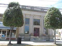
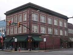
Clayton Banking Company Building |
|
000000001996-12-06-0000December 6, 1996
(#96001444) |
301 E. Main St.
35°38′59″N 78°27′29″W / 35.649722°N 78.458056°W / 35.649722; -78.458056 (Clayton Banking Company Building) |
Clayton |
|
| 7 |
Clayton Graded School and Clayton Grammar School-Municipal Auditorium |
Upload image |
000000002001-10-20-0000October 20, 2001
(#01001133) |
101 and 111 2nd St.
35°39′13″N 78°27′38″W / 35.653611°N 78.460556°W / 35.653611; -78.460556 (Clayton Graded School and Clayton Grammar School-Municipal Auditorium) |
Clayton |
|
| 8 |
Clayton Historic District |
|
000000002010-06-07-0000June 7, 2010
(#10000314) |
Bounded by Mulberry St., W Barnes St., Mill St., S Lombard St., Blanche St.
35°39′03″N 78°27′23″W / 35.650711°N 78.456392°W / 35.650711; -78.456392 (Clayton Historic District) |
Clayton |
|
| 9 |
Cleveland School |
Upload image |
000000002005-09-07-0000September 7, 2005
(#05000961) |
8968 Cleveland Rd.
35°34′06″N 78°31′43″W / 35.568333°N 78.528611°W / 35.568333; -78.528611 (Cleveland School) |
Clayton |
|
| 10 |
Downtown Selma Historic District |
Upload image |
000000002010-08-30-0000August 30, 2010
(#10000601) |
Includes portions of both sides of N. and S. Raiford, E. & W. Anderson, E. and W. Waddell, and E. and W. Railroad Sts, and W Web
35°32′12″N 78°17′04″W / 35.536667°N 78.284444°W / 35.536667; -78.284444 (Downtown Selma Historic District) |
Selma |
|
| 11 |
Downtown Smithfield Historic District |
|
000000001993-10-14-0000October 14, 1993
(#93001120) |
S. Third and Market Sts.
35°30′39″N 78°20′46″W / 35.510833°N 78.346111°W / 35.510833; -78.346111 (Downtown Smithfield Historic District) |
Smithfield |
|
| 12 |
Noah Edward Edgerton House |
Upload image |
000000001982-06-24-0000June 24, 1982
(#82003477) |
301 W. Railroad St.
35°32′10″N 78°17′49″W / 35.536111°N 78.296944°W / 35.536111; -78.296944 (Noah Edward Edgerton House) |
Selma |
|
| 13 |
Ellington-Ellis Farm |
Upload image |
000000001983-07-21-0000July 21, 1983
(#83001892) |
SR 1004
35°40′18″N 78°28′46″W / 35.671667°N 78.479444°W / 35.671667; -78.479444 (Ellington-Ellis Farm) |
Clayton |
|
| 14 |
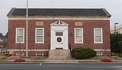
Former US Post Office |
|
000000001993-04-22-0000April 22, 1993
(#93000315) |
405 E. Market St.
35°30′38″N 78°20′39″W / 35.510689°N 78.344256°W / 35.510689; -78.344256 (Former US Post Office) |
Smithfield |
|
| 15 |
Four Oaks Commercial Historic District |
Upload image |
000000002006-08-09-0000August 9, 2006
(#06000692) |
100-300 blocks N. Main, 100-200 blocks S. Main, 100 block S.W. Railroad, 100 block W Wellons St. & 100 block W. Woodall St.
35°26′46″N 78°25′46″W / 35.446111°N 78.429444°W / 35.446111; -78.429444 (Four Oaks Commercial Historic District) |
Four Oaks |
|
| 16 |
Hannah's Creek Primitive Baptist Church |
Upload image |
000000001991-01-25-0000January 25, 1991
(#90002181) |
NC 301 southwest of junction with NC 1171
35°24′36″N 78°30′20″W / 35.41°N 78.505556°W / 35.41; -78.505556 (Hannah's Creek Primitive Baptist Church) |
Benson |
|
| 17 |
Harper House |
|
000000001970-02-26-0000February 26, 1970
(#70000459) |
Near junction of SR 1008 and 1188
35°18′05″N 78°19′57″W / 35.301389°N 78.3325°W / 35.301389; -78.3325 (Harper House) |
Harper |
|
| 18 |
Richard B. Harrison School |
Upload image |
000000002012-12-26-0000December 26, 2012
(#12001089) |
605 W. Noble & 405 S. Brevard Sts.
35°32′11″N 78°17′31″W / 35.536426°N 78.291966°W / 35.536426; -78.291966 (Richard B. Harrison School) |
Selma |
|
| 19 |
Hastings-McKinnie House |
Upload image |
000000001983-09-08-0000September 8, 1983
(#83001893) |
201 S. Pierce St.
35°27′43″N 78°09′24″W / 35.461944°N 78.156667°W / 35.461944; -78.156667 (Hastings-McKinnie House) |
Princeton |
|
| 20 |
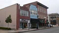
Hood Brothers Building |
|
000000001986-08-14-0000August 14, 1986
(#86001623) |
100-104 S. Third St.
35°30′40″N 78°20′47″W / 35.511128°N 78.346275°W / 35.511128; -78.346275 (Hood Brothers Building) |
Smithfield |
|
| 21 |
Hood-Strickland House |
|
000000001990-08-23-0000August 23, 1990
(#90001310) |
415 S. 4th St.
35°30′22″N 78°20′50″W / 35.50601°N 78.347157°W / 35.50601; -78.347157 (Hood-Strickland House) |
Smithfield |
|
| 22 |
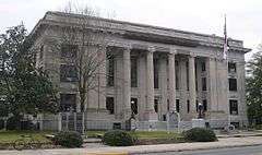
Johnston County Courthouse |
|
000000001979-05-10-0000May 10, 1979
(#79001728) |
Martin and 2nd Sts
35°30′41″N 78°20′50″W / 35.511287°N 78.347277°W / 35.511287; -78.347277 (Johnston County Courthouse) |
Smithfield |
|
| 23 |
Walter R. and Eliza Smith Moore House |
Upload image |
000000002005-05-04-0000May 4, 2005
(#05000379) |
3919 Raleigh Rd.
35°33′07″N 78°31′43″W / 35.551944°N 78.528611°W / 35.551944; -78.528611 (Walter R. and Eliza Smith Moore House) |
Clayton |
|
| 24 |
North Smithfield Historic District |
Upload image |
000000002000-05-26-0000May 26, 2000
(#00000550) |
Roughly bounded by Market, Front, North, and Seventh Sts.
35°30′49″N 78°20′38″W / 35.513611°N 78.343889°W / 35.513611; -78.343889 (North Smithfield Historic District) |
Smithfield |
|
| 25 |
Nowell-Mayerburg-Oliver House |
Upload image |
000000001982-06-24-0000June 24, 1982
(#82003478) |
312 W. Anderson St.
35°32′14″N 78°17′11″W / 35.537222°N 78.286389°W / 35.537222; -78.286389 (Nowell-Mayerburg-Oliver House) |
Selma |
|
| 26 |
Princeton Graded School |
Upload image |
000000002005-10-04-0000October 4, 2005
(#05001139) |
601-611 W. Edwards St.
35°28′11″N 78°10′07″W / 35.469753°N 78.168681°W / 35.469753; -78.168681 (Princeton Graded School) |
Princeton |
|
| 27 |
Sanders-Hairr House |
Upload image |
000000001971-05-06-0000May 6, 1971
(#71000597) |
South of Clayton on SR 1525
35°36′46″N 78°32′05″W / 35.612778°N 78.534722°W / 35.612778; -78.534722 (Sanders-Hairr House) |
Clayton |
|
| 28 |
Shiloh Primitive Baptist Church |
Upload image |
000000002008-01-31-0000January 31, 2008
(#07001498) |
9495 Brogden Rd.
35°24′21″N 78°12′41″W / 35.405833°N 78.211389°W / 35.405833; -78.211389 (Shiloh Primitive Baptist Church) |
Brogden |
|
| 29 |
William E. Smith House |
Upload image |
000000001982-06-24-0000June 24, 1982
(#82003480) |
309 W. Railroad St.
35°32′08″N 78°17′13″W / 35.535556°N 78.286944°W / 35.535556; -78.286944 (William E. Smith House) |
Selma |
|
| 30 |
Smithfield Masonic Lodge |
|
000000002007-09-28-0000September 28, 2007
(#07001012) |
115 N. Second St.
35°30′45″N 78°20′51″W / 35.51244°N 78.347375°W / 35.51244; -78.347375 (Smithfield Masonic Lodge) |
Smithfield |
|
| 31 |
Stallings-Carpenter House |
Upload image |
000000001983-03-28-0000March 28, 1983
(#83001894) |
SR 1713
35°41′26″N 78°27′27″W / 35.690556°N 78.4575°W / 35.690556; -78.4575 (Stallings-Carpenter House) |
Clayton |
|
| 32 |
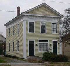
Everitt P. Stevens House |
Upload image |
000000001982-06-24-0000June 24, 1982
(#82003481) |
SR 1003
35°33′33″N 78°17′49″W / 35.559167°N 78.296944°W / 35.559167; -78.296944 (Everitt P. Stevens House) |
Selma |
|
| 33 |
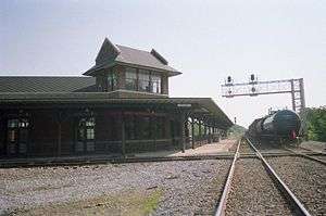
Union Station |
|
000000001982-06-24-0000June 24, 1982
(#82003482) |
E. Railroad St.
35°31′57″N 78°16′50″W / 35.5325°N 78.280556°W / 35.5325; -78.280556 (Union Station) |
Selma |
|
| 34 |
Watson-Sanders House |
Upload image |
000000002001-01-26-0000January 26, 2001
(#01000015) |
2810 Brogden Rd.
35°28′07″N 78°19′34″W / 35.468611°N 78.326111°W / 35.468611; -78.326111 (Watson-Sanders House) |
Smithfield |
|
| 35 |
West Selma Historic District |
Upload image |
000000002011-12-30-0000December 30, 2011
(#11000975) |
Bounded by W. Railroad, N. Brevard, W. Richardson & N. Pollock Sts.
35°32′20″N 78°17′09″W / 35.538897°N 78.285925°W / 35.538897; -78.285925 (West Selma Historic District) |
Selma |
|

.jpg)
_from_SSW_1.JPG)