| [3] |
Name on the Register[4] |
Image |
Date listed[5] |
Location |
City or town |
Description |
|---|
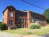
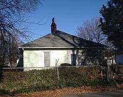
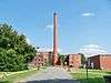
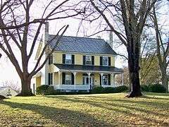
| 1 |
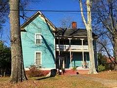
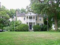
Banker's House |
|
000000001975-05-06-0000May 6, 1975
(#75001251) |
319 N. Lafayette St.
35°17′44″N 81°32′22″W / 35.295556°N 81.539444°W / 35.295556; -81.539444 (Banker's House) |
Shelby |
|
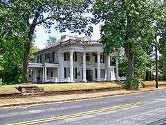
| 2 |
Joshua Beam House |
|
000000001980-06-04-0000June 4, 1980
(#80002813) |
Northeast of Shelby
35°20′47″N 81°29′10″W / 35.346389°N 81.486111°W / 35.346389; -81.486111 (Joshua Beam House) |
Shelby |
|
| 3 |
Central School Historic District |
|
000000002001-05-18-0000May 18, 2001
(#01000513) |
Roughly N. Battleground Ave., N. Piedmont Ave., E. King St., E. Ridge Ave., and N. Gaston St.
35°14′34″N 81°20′34″W / 35.242778°N 81.342778°W / 35.242778; -81.342778 (Central School Historic District) |
Kings Mountain |
|
| 4 |
Central Shelby Historic District |
|
000000001983-06-23-0000June 23, 1983
(#83001841) |
Roughly Washington St. from Gidney to Sumter, Graham and Warren Sts. to Morgan, and Marion St. from Washington St. to Thompson; also roughly bounded by E. Elm, S. Lafayette, Blanton, N. Thompson, W. Sumter, N. Lafayette, Kendal, and S. Dekalb Sts.
35°17′17″N 81°32′33″W / 35.288056°N 81.5425°W / 35.288056; -81.5425 (Central Shelby Historic District) |
Shelby |
Second set of boundaries represents a boundary increase of 000000002002-09-14-0000September 14, 2002
|
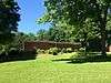
| 5 |
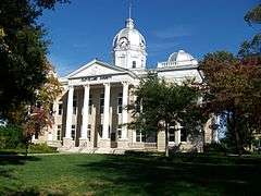
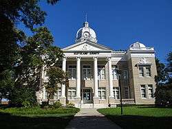
Cleveland County Courthouse |
|
000000001979-05-10-0000May 10, 1979
(#79001693) |
Marion, Washington, Warren, and Lafayette Sts.
35°17′29″N 81°32′22″W / 35.291389°N 81.539444°W / 35.291389; -81.539444 (Cleveland County Courthouse) |
Shelby |
Also called Old Cleveland County Courthouse.
|
| 6 |
Cleveland County Training School |
|
000000002016-05-02-0000May 2, 2016
(#16000220) |
341 Hudson St.
35°17′56″N 81°32′00″W / 35.299018°N 81.533314°W / 35.299018; -81.533314 (Cleveland County Training School) |
Shelby |
|
| 7 |
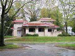
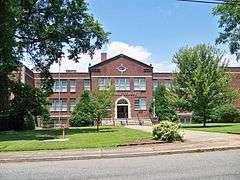
Davidson Elementary School |
|
000000002016-05-18-0000May 18, 2016
(#16000287) |
500 W. Piedmont Ave.
35°14′41″N 81°21′07″W / 35.2446°N 81.3520°W / 35.2446; -81.3520 (Davidson Elementary School) |
Kings Mountain |
|
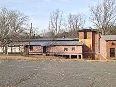
| 8 |
Double Shoals Cotton Mill |
|
000000002009-03-24-0000March 24, 2009
(#08000775) |
199 Old Mill Rd.
35°22′51″N 81°32′43″W / 35.380758°N 81.545208°W / 35.380758; -81.545208 (Double Shoals Cotton Mill) |
Double Shoals |
|
| 9 |
East Marion-Belvedere Park Historic District |
|
000000002002-12-31-0000December 31, 2002
(#02001667) |
Roughly bounded by Cline, Chestnut, E. Marion Sts., Edgemont Ave, Belvedere Aves., and Elizabeth Rd.
35°17′36″N 81°31′36″W / 35.293333°N 81.526667°W / 35.293333; -81.526667 (East Marion-Belvedere Park Historic District) |
Shelby |
|
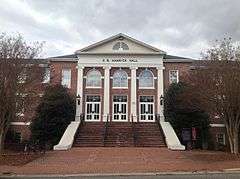
| 10 |
E. B. Hamrick Hall |
|
000000001982-07-12-0000July 12, 1982
(#82003444) |
Gardner-Webb College campus
35°14′58″N 81°40′05″W / 35.249444°N 81.668056°W / 35.249444; -81.668056 (E. B. Hamrick Hall) |
Boiling Springs |
|
| 11 |
James Heyward Hull House |
|
000000002003-05-01-0000May 1, 2003
(#03000338) |
710 N. Lafayette St.
35°18′01″N 81°32′22″W / 35.300278°N 81.539444°W / 35.300278; -81.539444 (James Heyward Hull House) |
Shelby |
|
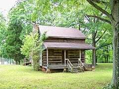
| 12 |
Irvin-Hamrick Log House |
|
000000001980-05-28-0000May 28, 1980
(#80002811) |
Northwest of Boiling Springs on SR 1153
35°16′35″N 81°37′33″W / 35.276389°N 81.625833°W / 35.276389; -81.625833 (Irvin-Hamrick Log House) |
Boiling Springs |
|
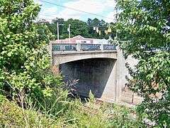
| 13 |
King Street Overhead Bridge |
|
000000002005-04-06-0000April 6, 2005
(#05000268) |
King St. between Battleground and Railroad Aves.
35°14′27″N 81°20′41″W / 35.240833°N 81.344722°W / 35.240833; -81.344722 (King Street Overhead Bridge) |
Kings Mountain |
|
| 14 |
John Lattimore House |
Upload image |
000000001982-08-26-0000August 26, 1982
(#82003445) |
Northwest of Polkville on SR 1372
35°26′35″N 81°39′57″W / 35.443056°N 81.665833°W / 35.443056; -81.665833 (John Lattimore House) |
Polkville |
|
| 15 |
Margrace Mill Village Historic District |
|
000000002009-05-06-0000May 6, 2009
(#09000288) |
101-117, 102-120 Cloninger St., 101-113, 102-116, 200 Fulton Dr., 145 Ark St., 101-107, 102-114 Water Oak St.
35°13′29″N 81°21′44″W / 35.224633°N 81.362233°W / 35.224633; -81.362233 (Margrace Mill Village Historic District) |
Kings Mountain |
|
| 16 |
Masonic Temple Building |
|
000000001982-07-15-0000July 15, 1982
(#82003446) |
203 S. Washington St.
35°16′54″N 81°32′18″W / 35.281667°N 81.538333°W / 35.281667; -81.538333 (Masonic Temple Building) |
Shelby |
|
| 17 |
Jacob S. Mauney Memorial Library and Teacher's Home |
|
000000002014-12-16-0000December 16, 2014
(#14001049) |
100 S. Piedmont Ave.
35°14′27″N 81°20′34″W / 35.2407°N 81.3429°W / 35.2407; -81.3429 (Jacob S. Mauney Memorial Library and Teacher's Home) |
Kings Mountain |
|
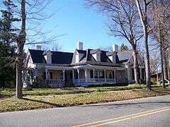
| 18 |
Dr. Victor McBrayer House |
|
000000001979-05-31-0000May 31, 1979
(#79001694) |
507 N. Morgan St.
35°17′39″N 81°32′30″W / 35.294167°N 81.541667°W / 35.294167; -81.541667 (Dr. Victor McBrayer House) |
Shelby |
|
| 19 |
Shelby Cotton Mill |
|
000000002015-12-15-0000December 15, 2015
(#15000898) |
500 S. Morgan St.
35°17′09″N 81°32′33″W / 35.285708°N 81.542464°W / 35.285708; -81.542464 (Shelby Cotton Mill) |
Shelby |
|
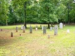
| 20 |
Shiloh Presbyterian Church Cemetery |
|
000000002011-12-22-0000December 22, 2011
(#11000954) |
Elm St., 0.9 miles (1.4 km) south of U.S. Route 29
35°10′09″N 81°25′57″W / 35.169297°N 81.432442°W / 35.169297; -81.432442 (Shiloh Presbyterian Church Cemetery) |
Grover |
|
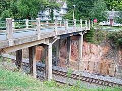
| 21 |
Southern Railway Company Overhead Bridge |
|
000000002007-04-19-0000April 19, 2007
(#07000351) |
Spanning the double tracks on the Norfolk Southern Railroad between Battleground and Railroad Aves., 1/2 block north of King St.
35°14′29″N 81°20′41″W / 35.241389°N 81.344722°W / 35.241389; -81.344722 (Southern Railway Company Overhead Bridge) |
Kings Mountain |
|
| 22 |
George Sperling House and Outbuildings |
|
000000002001-12-31-0000December 31, 2001
(#01001425) |
1219 Fallston Rd.
35°18′53″N 81°31′22″W / 35.314722°N 81.522778°W / 35.314722; -81.522778 (George Sperling House and Outbuildings) |
Shelby |
|
| 23 |
Joseph Suttle House |
|
000000001980-07-17-0000July 17, 1980
(#80002814) |
Southwest of Shelby
35°15′55″N 81°35′09″W / 35.265278°N 81.585833°W / 35.265278; -81.585833 (Joseph Suttle House) |
Shelby |
|
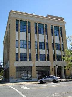
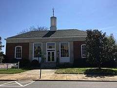
| 24 |
United States Post Office |
|
000000002015-04-29-0000April 29, 2015
(#15000202) |
100 E. Mountain St.
35°14′21″N 81°20′32″W / 35.2391°N 81.3421°W / 35.2391; -81.3421 (United States Post Office) |
Kings Mountain |
Now the Kings Mountain Historical Museum
|
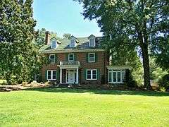
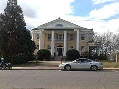
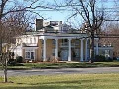
| 25 |
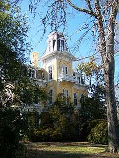
Webbley |
|
000000001980-09-29-0000September 29, 1980
(#80002812) |
403 S. Washington St.
35°17′14″N 81°32′20″W / 35.287222°N 81.538889°W / 35.287222; -81.538889 (Webbley) |
Shelby |
|
| 26 |
West End Historic District |
|
000000002010-09-03-0000September 3, 2010
(#10000630) |
Bounded by W. Mountain St., W. Gold St., S. Cansler St., S. Tracy St., S. Watterson St., and S. Goforth St.
35°14′19″N 81°21′00″W / 35.238611°N 81.35°W / 35.238611; -81.35 (West End Historic District) |
Kings Mountain |
|
| 27 |
West Warren Street Historic District |
|
000000002009-05-12-0000May 12, 2009
(#09000331) |
Roughly bounded by W. Warren, McBrayer, Blanton, and Whisnant Sts.
35°17′28″N 81°32′40″W / 35.291028°N 81.544414°W / 35.291028; -81.544414 (West Warren Street Historic District) |
Shelby |
|

_-_Shelby%2C_NC.jpg)