| [3] |
Name on the Register[4] |
Image |
Date listed[5] |
Location |
City or town |
Description |
|---|
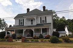
| 1 |
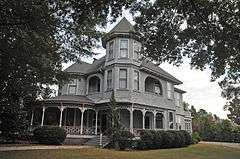
Aberdeen Historic District |
|
000000001989-06-28-0000June 28, 1989
(#89000663) |
Roughly bounded by Maple Ave., Bethesda Ave., Campbell St., Main St., Pine St., South St., and Poplar St.
35°07′53″N 79°25′29″W / 35.131389°N 79.424722°W / 35.131389; -79.424722 (Aberdeen Historic District) |
Aberdeen |
|
| 2 |
Alston House |
|
000000001970-02-26-0000February 26, 1970
(#70000462) |
SE of Glendon on SR 1624
35°28′00″N 79°23′02″W / 35.466797°N 79.383867°W / 35.466797; -79.383867 (Alston House) |
Glendon |
|
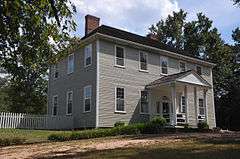
| 3 |
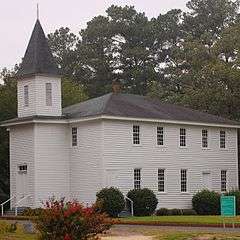
Bethesda Presbyterian Church |
|
000000001979-07-22-0000July 22, 1979
(#79003345) |
NC 5
35°07′52″N 79°24′45″W / 35.131111°N 79.4125°W / 35.131111; -79.4125 (Bethesda Presbyterian Church) |
Aberdeen |
|
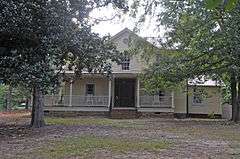
| 4 |
J.C. Black House |
|
000000001999-07-08-0000July 8, 1999
(#99000811) |
106 McNeill St.
35°20′44″N 79°24′55″W / 35.345556°N 79.415278°W / 35.345556; -79.415278 (J.C. Black House) |
Carthage |
|
| 5 |
Black-Cole House |
Upload image |
000000001978-09-18-0000September 18, 1978
(#78001967) |
NW of Eastwood
35°16′03″N 79°29′16″W / 35.2675°N 79.487778°W / 35.2675; -79.487778 (Black-Cole House) |
Eastwood |
|
| 6 |
Daniel Blue House |
Upload image |
000000001983-07-21-0000July 21, 1983
(#83001897) |
SR 1836
35°16′55″N 79°25′32″W / 35.281944°N 79.425556°W / 35.281944; -79.425556 (Daniel Blue House) |
Carthage |
|
| 7 |
John Blue House |
Upload image |
000000001982-07-29-0000July 29, 1982
(#82003488) |
200 Blue St.
35°07′50″N 79°25′22″W / 35.130556°N 79.422778°W / 35.130556; -79.422778 (John Blue House) |
Aberdeen |
|
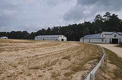
| 8 |
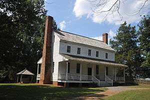
Malcolm Blue Farm |
Upload image |
000000001982-06-01-0000June 1, 1982
(#82003489) |
Bethesda Rd. and Ernest L. Ives Dr.
35°08′08″N 79°24′38″W / 35.135556°N 79.410556°W / 35.135556; -79.410556 (Malcolm Blue Farm) |
Aberdeen |
|
| 9 |
James Boyd House |
|
000000001977-05-12-0000May 12, 1977
(#77001005) |
Ridge Rd. and Connecticut Ave.
35°10′14″N 79°23′00″W / 35.170556°N 79.383333°W / 35.170556; -79.383333 (James Boyd House) |
Southern Pines |
|
| 10 |
Bruce-Dowd-Kennedy House |
Upload image |
000000001980-09-29-0000September 29, 1980
(#80002888) |
Monroe and Rockingham Sts.
35°20′34″N 79°24′48″W / 35.342778°N 79.413333°W / 35.342778; -79.413333 (Bruce-Dowd-Kennedy House) |
Carthage |
|
| 11 |
James Bryant House |
Upload image |
000000001982-04-15-0000April 15, 1982
(#82003490) |
On SR 1210
35°19′07″N 79°32′41″W / 35.318611°N 79.544722°W / 35.318611; -79.544722 (James Bryant House) |
Harris Crossroads |
|
| 12 |
Cameron Historic District |
Upload image |
000000001983-03-17-0000March 17, 1983
(#83001898) |
Carthage St. from US 1 to Seaboard RR Tracks
35°19′36″N 79°15′28″W / 35.326667°N 79.257778°W / 35.326667; -79.257778 (Cameron Historic District) |
Cameron |
|
| 13 |
Carthage Historic District |
|
000000001992-03-19-0000March 19, 1992
(#92000182) |
Roughly, McReynolds St. between Barrett St. and Glendons Rd. and parts of Barrett, Ray, Pinecrest and Brooklyn Sts.
35°21′04″N 79°25′23″W / 35.351111°N 79.423056°W / 35.351111; -79.423056 (Carthage Historic District) |
Carthage |
|
| 14 |
Firleigh Farms |
Upload image |
000000002014-05-19-0000May 19, 2014
(#14000229) |
252 Fir Leigh Rd.
35°10′16″N 79°21′17″W / 35.1710°N 79.3546°W / 35.1710; -79.3546 (Firleigh Farms) |
Southern Pines vicinity |
|
| 15 |
Gordon Payne Site (31MR15) |
|
000000001986-09-24-0000September 24, 1986
(#86001954) |
Address Restricted
|
High Falls |
|
| 16 |
Jugtown Pottery |
Upload image |
000000001999-11-12-0000November 12, 1999
(#99001284) |
330 Jugtown Rd.
35°30′27″N 79°39′06″W / 35.5075°N 79.651667°W / 35.5075; -79.651667 (Jugtown Pottery) |
Seagrove |
|
| 17 |
Alexander Kelly House |
|
000000002002-05-02-0000May 2, 2002
(#02000438) |
NC 1640, 0.3 miles SE of jct. with NC 1666
35°22′34″N 79°26′46″W / 35.376111°N 79.446111°W / 35.376111; -79.446111 (Alexander Kelly House) |
Carthage |
|
| 18 |
Lakeview Historic District |
Upload image |
000000002000-05-18-0000May 18, 2000
(#00000513) |
Camp Easter Rd., Crystal Lake Dr., Holly Rd., Matthews Rd., and McFayden Ln.
35°14′25″N 79°18′41″W / 35.240278°N 79.311389°W / 35.240278; -79.311389 (Lakeview Historic District) |
Lakeview |
|
| 19 |
Leslie-Taylor House |
Upload image |
000000002008-01-17-0000January 17, 2008
(#07001407) |
270 Carthage Rd.
35°15′26″N 79°17′47″W / 35.257233°N 79.2963°W / 35.257233; -79.2963 (Leslie-Taylor House) |
Vass |
|
| 20 |
Lincoln Park School |
Upload image |
000000001997-02-27-0000February 27, 1997
(#97000167) |
1272 S. Currant St.
35°05′06″N 79°28′25″W / 35.085°N 79.473611°W / 35.085; -79.473611 (Lincoln Park School) |
Pinebluff |
|
| 21 |
Lloyd-Howe House |
|
000000001983-09-08-0000September 8, 1983
(#83001899) |
SW of Pinehurst
35°11′15″N 79°29′38″W / 35.1875°N 79.493889°W / 35.1875; -79.493889 (Lloyd-Howe House) |
Pinehurst |
|
| 22 |
McLeod Family Rural Complex |
Upload image |
000000001984-12-20-0000December 20, 1984
(#84000561) |
.4 miles west of US 1
35°04′33″N 79°30′06″W / 35.075833°N 79.501667°W / 35.075833; -79.501667 (McLeod Family Rural Complex) |
Pinebluff |
|
| 23 |
Moore County Courthouse |
|
000000001979-05-10-0000May 10, 1979
(#79001738) |
Ray, Dowd, Monroe, and Sanders Sts. circle
35°20′44″N 79°25′00″W / 35.345556°N 79.416667°W / 35.345556; -79.416667 (Moore County Courthouse) |
Carthage |
|
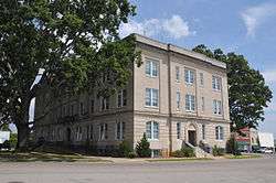
| 24 |
Moore County Hunt Lands and Mile-Away Farms |
Upload image |
000000002013-09-09-0000September 9, 2013
(#13000700) |
1745 N. May St.
35°11′14″N 79°22′00″W / 35.187094°N 79.366683°W / 35.187094; -79.366683 (Moore County Hunt Lands and Mile-Away Farms) |
Southern Pines vicinity |
|
| 25 |
John Evander Phillips House |
Upload image |
000000002000-10-06-0000October 6, 2000
(#00001184) |
NC 24/27, 0.3 mi outside Cameron
35°19′47″N 79°15′45″W / 35.329722°N 79.2625°W / 35.329722; -79.2625 (John Evander Phillips House) |
Cameron |
|
| 26 |
Pinehurst Historic District |
|
000000001973-08-14-0000August 14, 1973
(#73001361) |
Roughly bounded by Norfolk & Southern RR tracks, McLean Rd. and NC 5
35°11′41″N 79°28′11″W / 35.194722°N 79.469722°W / 35.194722; -79.469722 (Pinehurst Historic District) |
Pinehurst |
|
| 27 |
Pinehurst Race Track |
|
000000001992-11-27-0000November 27, 1992
(#92001628) |
Jct. of Morgantown Rd. and NC 5, SE corner
35°10′54″N 79°27′59″W / 35.181667°N 79.466389°W / 35.181667; -79.466389 (Pinehurst Race Track) |
Pinehurst |
|
| 28 |
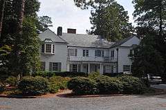
Shaw House |
|
000000001993-06-17-0000June 17, 1993
(#93000542) |
780 SW. Broad St.
35°10′05″N 79°24′06″W / 35.168056°N 79.401667°W / 35.168056; -79.401667 (Shaw House) |
Southern Pines |
|
| 29 |
Southern Pines Historic District |
|
000000001991-12-27-0000December 27, 1991
(#91001875) |
Bounded by Saylor St., New Jersey Ave., Illinois Ave. and Massachusetts Ave. Ext.
35°10′10″N 79°23′17″W / 35.169444°N 79.388056°W / 35.169444; -79.388056 (Southern Pines Historic District) |
Southern Pines |
|


_001.jpg)