| [3] |
Name on the Register[4] |
Image |
Date listed[5] |
Location |
City or town |
Description |
|---|
| 1 |
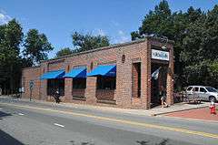
Alberta Mill Complex |
|
000000001976-01-19-0000January 19, 1976
(#76001332) |
NE corner Weaver and N. Greensboro Sts.
35°54′41″N 79°04′17″W / 35.911389°N 79.071389°W / 35.911389; -79.071389 (Alberta Mill Complex) |
Carrboro |
|
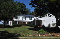
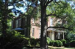
| 2 |
Ayr Mount |
|
000000001971-08-26-0000August 26, 1971
(#71000606) |
St. Mary's Rd.
36°04′37″N 79°05′30″W / 36.076944°N 79.091667°W / 36.076944; -79.091667 (Ayr Mount) |
Hillsborough |
|
| 3 |
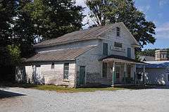
Bellevue Manufacturing Company |
|
000000002003-08-28-0000August 28, 2003
(#03000858) |
Nash St. and Eno St.
36°04′23″N 79°06′41″W / 36.073056°N 79.111389°W / 36.073056; -79.111389 (Bellevue Manufacturing Company) |
Hillsborough |
|
| 4 |
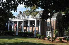
Beta Theta Pi Fraternity House |
|
000000002005-04-20-0000April 20, 2005
(#05000325) |
114 South Columbia St.
35°54′49″N 79°03′20″W / 35.913611°N 79.055556°W / 35.913611; -79.055556 (Beta Theta Pi Fraternity House) |
Chapel Hill |
|
| 5 |
Bingham School |
|
000000001978-01-18-0000January 18, 1978
(#78001969) |
NC 54 and SR 1007
35°57′13″N 79°15′16″W / 35.953611°N 79.254444°W / 35.953611; -79.254444 (Bingham School) |
Oaks |
|
| 6 |
Burwell School |
|
000000001970-09-15-0000September 15, 1970
(#70000465) |
N. Churton St.
36°04′45″N 79°06′00″W / 36.079167°N 79.1°W / 36.079167; -79.1 (Burwell School) |
Hillsborough |
|
| 7 |
Cabe-Pratt-Harris House |
Upload image |
000000001999-04-22-0000April 22, 1999
(#99000481) |
NC 1567. 0.9 miles N. of Eno River Bridge
36°03′29″N 79°00′28″W / 36.058056°N 79.007778°W / 36.058056; -79.007778 (Cabe-Pratt-Harris House) |
Hillsborough |
|
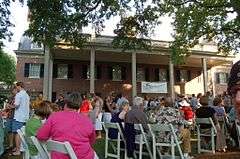
| 8 |
Carolina Inn |
|
000000001999-08-06-0000August 6, 1999
(#99000867) |
211 Pittsboro St.
35°54′36″N 79°03′18″W / 35.91°N 79.055°W / 35.91; -79.055 (Carolina Inn) |
Chapel Hill |
|
| 9 |
Carrboro Commercial Historic District |
|
000000001985-06-20-0000June 20, 1985
(#85001339) |
100 Blk. of E. Main St. between Greensboro Rd. & Roberson St.
35°54′37″N 79°04′18″W / 35.910278°N 79.071667°W / 35.910278; -79.071667 (Carrboro Commercial Historic District) |
Carrboro |
|
| 10 |
Cedar Grove Rural Crossroads Historic District |
|
000000001998-04-23-0000April 23, 1998
(#98000389) |
Roughly along Carr Store Rd. and Efland-Cedar Grove Rd.
36°10′12″N 79°10′11″W / 36.17°N 79.169722°W / 36.17; -79.169722 (Cedar Grove Rural Crossroads Historic District) |
Cedar Grove |
|
| 11 |
Chapel Hill Historic District |
|
000000001971-12-16-0000December 16, 1971
(#71000604) |
Battle Park, E. Franklin and E. Rosemary Sts. residences, and central campus of University of North Carolina; also roughly bounded by Carolina Ave., North, Cameron & Columbia Sts.
35°54′45″N 79°03′08″W / 35.9125°N 79.052222°W / 35.9125; -79.052222 (Chapel Hill Historic District) |
Chapel Hill |
Second set of addresses represents a boundary increase, 2015
|
| 12 |
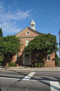
Chapel Hill Town Hall |
|
000000001990-03-20-0000March 20, 1990
(#90000364) |
Rosemary and Columbia Sts.
35°54′51″N 79°03′25″W / 35.914167°N 79.056944°W / 35.914167; -79.056944 (Chapel Hill Town Hall) |
Chapel Hill |
|
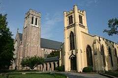
| 13 |
Chapel of the Cross |
|
000000001972-02-01-0000February 1, 1972
(#72000980) |
304 E. Franklin St.
35°54′58″N 79°02′39″W / 35.916111°N 79.044167°W / 35.916111; -79.044167 (Chapel of the Cross) |
Chapel Hill |
|
| 14 |
Commandant's House |
|
000000001972-11-09-0000November 9, 1972
(#72000981) |
Barracks Rd.
36°04′19″N 79°07′22″W / 36.071944°N 79.122778°W / 36.071944; -79.122778 (Commandant's House) |
Hillsborough |
|
| 15 |
Eagle Lodge |
|
000000001971-04-16-0000April 16, 1971
(#71000607) |
142 W. King St.
36°04′31″N 79°05′59″W / 36.075278°N 79.099722°W / 36.075278; -79.099722 (Eagle Lodge) |
Hillsborough |
Masonic Lodge
|
| 16 |
Eno Cotton Mill |
|
000000002011-09-01-0000September 1, 2011
(#11000622) |
437 Dimmocks Mill Rd.
36°04′14″N 79°06′48″W / 36.070556°N 79.113333°W / 36.070556; -79.113333 (Eno Cotton Mill) |
Hillsborough |
|
| 17 |
Faucett Mill and House |
|
000000001988-08-04-0000August 4, 1988
(#88001175) |
Faucette Mill Rd. on the E side of Eno River
36°06′04″N 79°08′25″W / 36.101111°N 79.140278°W / 36.101111; -79.140278 (Faucett Mill and House) |
Hillsborough |
|
| 18 |
David Faucette House |
|
000000001999-11-22-0000November 22, 1999
(#99001391) |
1830 Hall's Mill Rd.
36°07′21″N 79°09′20″W / 36.1225°N 79.155556°W / 36.1225; -79.155556 (David Faucette House) |
Efland |
|
| 19 |
Gimghoul Neighborhood Historic District |
|
000000001993-08-05-0000August 5, 1993
(#93000807) |
Roughly bounded by Gimghoul Rd., Ridge Ln., and Gladon Dr.
35°54′47″N 79°02′24″W / 35.913056°N 79.04°W / 35.913056; -79.04 (Gimghoul Neighborhood Historic District) |
Chapel Hill |
|
| 20 |
Hazel-Nash House |
|
000000001971-03-31-0000March 31, 1971
(#71000608) |
116 W. Queen St.
36°04′44″N 79°06′04″W / 36.078889°N 79.101111°W / 36.078889; -79.101111 (Hazel-Nash House) |
Hillsborough |
|
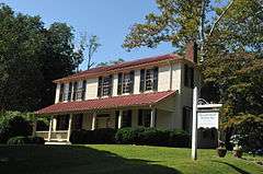
| 21 |
Heartsease |
|
000000001973-04-11-0000April 11, 1973
(#73001362) |
113 E. Queen St.
36°04′44″N 79°06′07″W / 36.078889°N 79.101944°W / 36.078889; -79.101944 (Heartsease) |
Hillsborough |
|
| 22 |
Hillsborough Historic District |
|
000000001973-10-15-0000October 15, 1973
(#73001363) |
Roughly bounded by N. Nash and W. Corbin Sts., Highland Loop Rd., and Eno River
36°04′25″N 79°05′44″W / 36.073611°N 79.095556°W / 36.073611; -79.095556 (Hillsborough Historic District) |
Hillsborough |
|
| 23 |
Alexander Hogan Plantation |
|
000000001996-03-04-0000March 4, 1996
(#96000186) |
Address Restricted
|
Chapel Hill |
|
| 24 |
Thomas and Mary Hogan House |
|
000000002001-01-26-0000January 26, 2001
(#01000016) |
9118 Hillsborough Rd.
35°56′27″N 79°06′15″W / 35.940833°N 79.104167°W / 35.940833; -79.104167 (Thomas and Mary Hogan House) |
Carrboro |
|
| 25 |
Holden-Roberts Farm |
|
000000002002-05-02-0000May 2, 2002
(#02000436) |
NC 1002, 1 miles E of NC 1538
36°06′36″N 79°02′11″W / 36.11°N 79.036389°W / 36.11; -79.036389 (Holden-Roberts Farm) |
Hillsborough |
|
| 26 |
Jacob Jackson Farm |
|
000000001994-03-17-0000March 17, 1994
(#94000184) |
NC 1002, 0.4 miles W of NC 1538
36°05′35″N 79°03′37″W / 36.093056°N 79.060278°W / 36.093056; -79.060278 (Jacob Jackson Farm) |
Hillsborough |
|
| 27 |
Dr. Arch Jordan House |
|
000000001998-08-06-0000August 6, 1998
(#98000995) |
7015 NC 57
36°11′06″N 79°01′08″W / 36.185°N 79.018889°W / 36.185; -79.018889 (Dr. Arch Jordan House) |
Caldwell |
|
| 28 |
Thomas F. Lloyd Historic District |
|
000000001986-08-14-0000August 14, 1986
(#86001625) |
Roughly bounded by E. Carr St., Maple Ave., and S. Greensboro St.
35°54′26″N 79°04′17″W / 35.907222°N 79.071389°W / 35.907222; -79.071389 (Thomas F. Lloyd Historic District) |
Carrboro |
|
| 29 |
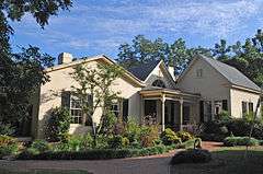
Montrose |
|
000000002001-10-28-0000October 28, 2001
(#01001187) |
320 St. Mary's Rd.
36°04′41″N 79°08′36″W / 36.078056°N 79.143333°W / 36.078056; -79.143333 (Montrose) |
Hillsborough |
|
| 30 |
Moorefields |
|
000000001972-04-25-0000April 25, 1972
(#72000982) |
N of jct. of SR 1134 and 1135
36°03′07″N 79°08′43″W / 36.051944°N 79.145278°W / 36.051944; -79.145278 (Moorefields) |
Hillsborough |
|
| 31 |
Murphey School |
|
000000002009-08-20-0000August 20, 2009
(#09000637) |
3729 Murphy School Rd.
36°01′44″N 79°00′52″W / 36.028908°N 79.014314°W / 36.028908; -79.014314 (Murphey School) |
Hillsborough |
|
| 32 |
Nash Law Office |
|
000000001971-09-28-0000September 28, 1971
(#71000609) |
143 W. Margaret Lane
36°04′27″N 79°06′05″W / 36.074167°N 79.101389°W / 36.074167; -79.101389 (Nash Law Office) |
Hillsborough |
|
| 33 |
Nash-Hooper House |
|
000000001971-11-11-0000November 11, 1971
(#71000610) |
118 W. Tryon St.
36°04′03″N 79°06′03″W / 36.0675°N 79.100833°W / 36.0675; -79.100833 (Nash-Hooper House) |
Hillsborough |
|
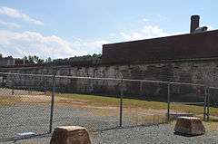
| 34 |
Occoneechee Speedway |
|
000000002002-05-02-0000May 2, 2002
(#02000435) |
Elizabeth Brady, 0.3 N of US 70 Business
36°04′23″N 79°04′57″W / 36.073056°N 79.0825°W / 36.073056; -79.0825 (Occoneechee Speedway) |
Hillsborough |
|
| 35 |
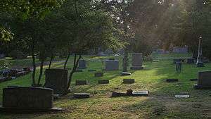
Old Chapel Hill Cemetery |
|
000000001994-06-03-0000June 3, 1994
(#94000570) |
Jct. of NC 54 and County Club Rd., NW corner
35°54′40″N 79°02′34″W / 35.911111°N 79.042778°W / 35.911111; -79.042778 (Old Chapel Hill Cemetery) |
Chapel Hill |
|
| 36 |
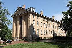
Old East, University of North Carolina |
|
000000001966-10-15-0000October 15, 1966
(#66000596) |
University of North Carolina campus
35°54′45″N 79°03′03″W / 35.9125°N 79.050833°W / 35.9125; -79.050833 (Old East, University of North Carolina) |
Chapel Hill |
|
| 37 |
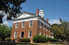
Old Orange County Courthouse |
|
000000001971-06-24-0000June 24, 1971
(#71000611) |
106 E. King St.
36°05′34″N 79°05′56″W / 36.092778°N 79.098889°W / 36.092778; -79.098889 (Old Orange County Courthouse) |
Hillsborough |
|
| 38 |
Paisley-Rice Log House |
Upload image |
000000001979-01-31-0000January 31, 1979
(#79001740) |
N of Mebane
36°07′33″N 79°15′22″W / 36.125833°N 79.256111°W / 36.125833; -79.256111 (Paisley-Rice Log House) |
Mebane |
|
| 39 |
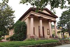
Playmakers Theatre |
|
000000001971-06-24-0000June 24, 1971
(#71000605) |
Cameron Ave., University of North Carolina campus
35°54′24″N 79°03′02″W / 35.906667°N 79.050556°W / 35.906667; -79.050556 (Playmakers Theatre) |
Chapel Hill |
|
| 40 |
Capt. John S. Pope Farm |
|
000000002013-04-23-0000April 23, 2013
(#13000206) |
6909 Efland-Cedar Grove Rd.
36°11′53″N 79°10′09″W / 36.198105°N 79.169107°W / 36.198105; -79.169107 (Capt. John S. Pope Farm) |
Cedar Grove |
|
| 41 |
Rigsbee's Rock House |
|
000000001988-10-20-0000October 20, 1988
(#88002026) |
Jct. of Lawrence Rd. and US 70W Bypass
36°03′34″N 79°04′01″W / 36.059444°N 79.066944°W / 36.059444; -79.066944 (Rigsbee's Rock House) |
Hillsborough |
|
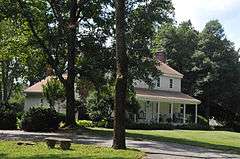
| 42 |
Rocky Ridge Farm Historic District |
|
000000001989-08-08-0000August 8, 1989
(#89001039) |
Roughly bounded by Rocky Ridge Rd., Country Club Rd., Laurel Hill Rd., Laurel Hill Cir., and Buttons Dr.; also portions of Country Club Rd., Laurel Hill Rd., and Ledge Ln., and all of Round Hill Rd.
35°54′21″N 79°02′18″W / 35.905833°N 79.038333°W / 35.905833; -79.038333 (Rocky Ridge Farm Historic District) |
Chapel Hill |
Second set of boundaries represents a boundary increase of 000000002008-01-30-0000January 30, 2008
|
| 43 |
Ruffin-Roulhac House |
|
000000001971-08-05-0000August 5, 1971
(#71000612) |
Churton and Orange Sts.
36°04′54″N 79°05′58″W / 36.081667°N 79.099444°W / 36.081667; -79.099444 (Ruffin-Roulhac House) |
Hillsborough |
|
| 44 |
Sans Souci |
|
000000001971-08-26-0000August 26, 1971
(#71000613) |
E. Corbin St.
36°04′57″N 79°05′47″W / 36.0825°N 79.096389°W / 36.0825; -79.096389 (Sans Souci) |
Hillsborough |
|
| 45 |
St. Mary's Chapel |
|
000000001978-07-12-0000July 12, 1978
(#78001968) |
NE of Hillsborough
36°07′03″N 79°00′01″W / 36.1175°N 79.000278°W / 36.1175; -79.000278 (St. Mary's Chapel) |
Hillsborough |
|
| 46 |
St. Matthew's Episcopal Church and Churchyard |
|
000000001971-06-24-0000June 24, 1971
(#71000614) |
St. Mary's Rd.
36°04′35″N 79°05′43″W / 36.076389°N 79.095278°W / 36.076389; -79.095278 (St. Matthew's Episcopal Church and Churchyard) |
Hillsborough |
|
| 47 |
West Chapel Hill Historic District |
|
000000001998-12-31-0000December 31, 1998
(#98001528) |
Roughly bounded by W. Cameron Ave., Malette St., Ranson St., Pittsboro St., University Dr. and the Westwood Subdivision
35°54′23″N 79°03′31″W / 35.906389°N 79.058611°W / 35.906389; -79.058611 (West Chapel Hill Historic District) |
Chapel Hill |
|

.jpg)
.jpg)
.jpg)
.jpg)
.jpg)
.jpg)
.jpg)
.jpg)
.jpg)