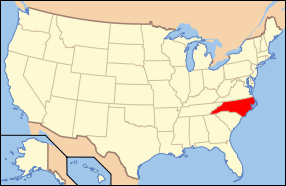
| [3] |
Name on the Register[4] |
Image |
Date listed[5] |
Location |
City or town |
Description |
|---|
| 1 |
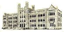
Bell-Sherrod House |
Upload image |
000000001988-10-20-0000October 20, 1988
(#88002027) |
207 SE Railroad St.
36°10′41″N 77°40′06″W / 36.178056°N 77.668333°W / 36.178056; -77.668333 (Bell-Sherrod House) |
Enfield |
|
| 2 |
Bellamy's Mill |
Upload image |
000000001974-11-05-0000November 5, 1974
(#74001351) |
Southwest of Enfield
36°09′16″N 77°44′36″W / 36.154444°N 77.743333°W / 36.154444; -77.743333 (Bellamy's Mill) |
Enfield |
|
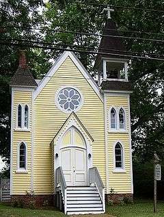
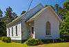
| 3 |
Bethesda Methodist Protestant Church |
Upload image |
000000002012-08-28-0000August 28, 2012
(#12000576) |
30974 NC 561
36°16′25″N 77°50′28″W / 36.273726°N 77.840984°W / 36.273726; -77.840984 (Bethesda Methodist Protestant Church) |
Brinkleyville |
|
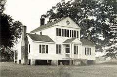
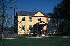
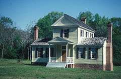
| 4 |
Samuel Warren Branch House |
|
000000001982-06-14-0000June 14, 1982
(#82003464) |
NC 481
36°11′53″N 77°37′40″W / 36.198056°N 77.627778°W / 36.198056; -77.627778 (Samuel Warren Branch House) |
Enfield |
|
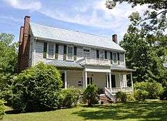
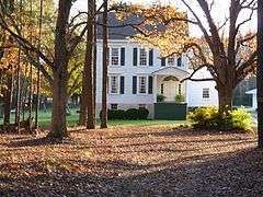
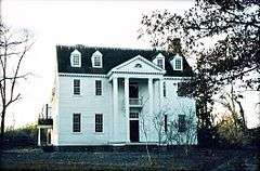
| 5 |
The Cellar |
|
000000001979-09-20-0000September 20, 1979
(#79003336) |
404 Whitfield St.
36°11′04″N 77°40′21″W / 36.184444°N 77.6725°W / 36.184444; -77.6725 (The Cellar) |
Enfield |
|
| 6 |
Church of the Immaculate Conception and the Michael Ferrall Family Cemetery |
|
000000001997-06-04-0000June 4, 1997
(#97000533) |
145 S. King St.
36°19′33″N 77°35′29″W / 36.325833°N 77.591389°W / 36.325833; -77.591389 (Church of the Immaculate Conception and the Michael Ferrall Family Cemetery) |
Halifax |
|
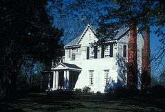
| 7 |
William R. Davie House |
|
000000001973-06-19-0000June 19, 1973
(#73001348) |
Norman St.
36°19′52″N 77°35′31″W / 36.331156°N 77.592042°W / 36.331156; -77.592042 (William R. Davie House) |
Halifax |
|
| 8 |
Eagle Tavern |
|
000000001973-04-24-0000April 24, 1973
(#73001349) |
Main St.
36°19′47″N 77°35′20″W / 36.329722°N 77.588875°W / 36.329722; -77.588875 (Eagle Tavern) |
Halifax |
|
| 9 |
Edmunds-Heptinstall House |
|
000000001979-03-12-0000March 12, 1979
(#79001718) |
Northwest of Aurelian Springs on NC 1001
36°22′16″N 77°50′12″W / 36.371111°N 77.836667°W / 36.371111; -77.836667 (Edmunds-Heptinstall House) |
Aurelian Springs |
|
| 10 |
Enfield Graded School |
|
000000002009-01-08-0000January 8, 2009
(#08001290) |
700 Branch St.
36°11′03″N 77°40′32″W / 36.184278°N 77.675458°W / 36.184278; -77.675458 (Enfield Graded School) |
Enfield |
|
| 11 |
Garner Farm |
Upload image |
000000001990-06-07-0000June 7, 1990
(#90000826) |
Junction of NC 125 and I-95
36°23′58″N 77°38′54″W / 36.399444°N 77.648333°W / 36.399444; -77.648333 (Garner Farm) |
Days Crossroads |
|
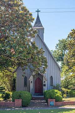
| 12 |
Grace Episcopal Church |
Upload image |
000000001991-10-01-0000October 1, 1991
(#91001493) |
404 Washington Ave.
36°25′31″N 77°35′57″W / 36.425278°N 77.599167°W / 36.425278; -77.599167 (Grace Episcopal Church) |
Weldon |
|
| 13 |
Gray-Brownlow-Wilcox House |
Upload image |
000000001982-08-03-0000August 3, 1982
(#82003463) |
South of Brinkleyville on NC 58
36°15′34″N 77°51′46″W / 36.259325°N 77.862719°W / 36.259325; -77.862719 (Gray-Brownlow-Wilcox House) |
Brinkleyville |
|
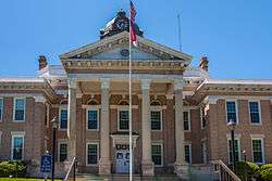
| 14 |
Halifax County Courthouse |
|
000000001979-05-10-0000May 10, 1979
(#79001719) |
Main St.
36°19′51″N 77°35′22″W / 36.330833°N 77.589444°W / 36.330833; -77.589444 (Halifax County Courthouse) |
Halifax |
part of the North Carolina County Courthouses Thematic Resource (TR)
|
| 15 |
Halifax County Home and Tubercular Hospital |
|
000000001985-12-10-0000December 10, 1985
(#85003338) |
NC 903
36°21′12″N 77°37′17″W / 36.353333°N 77.621389°W / 36.353333; -77.621389 (Halifax County Home and Tubercular Hospital) |
Halifax |
|
| 16 |
Halifax Historic District |
|
000000001970-01-21-0000January 21, 1970
(#70000456) |
Roughly bounded by St. David St., Owens House Drainage Ditch, Roanoke River, and Magazine Spring Gut
• Boundary increase (listed 000000002011-01-14-0000January 14, 2011, refnum 10001128): Bounded by St. David, Montfort, Pittsylvania, Prussia, Church, Wilcox, Granville, Ferguson Sts, and Highway 301
36°19′56″N 77°35′16″W / 36.332222°N 77.587778°W / 36.332222; -77.587778 (Halifax Historic District) |
Halifax |
|
| 17 |
The Hermitage |
Upload image |
000000001975-05-29-0000May 29, 1975
(#75001274) |
1 mile (1.6 km) west of Tillery off NC 481
36°14′30″N 77°30′23″W / 36.241667°N 77.506389°W / 36.241667; -77.506389 (The Hermitage) |
Tillery |
|
| 18 |
Hoffman-Bowers-Josey-Riddick House |
Upload image |
000000001988-12-29-0000December 29, 1988
(#88003080) |
1103 Church St.
36°07′47″N 77°25′25″W / 36.129722°N 77.423611°W / 36.129722; -77.423611 (Hoffman-Bowers-Josey-Riddick House) |
Scotland Neck |
|
| 19 |
Kehukee Primitive Baptist Church |
Upload image |
000000001994-02-04-0000February 4, 1994
(#94000023) |
NC 1810 northeast side, just east of the junction with NC 125
36°06′21″N 77°24′54″W / 36.105833°N 77.415°W / 36.105833; -77.415 (Kehukee Primitive Baptist Church) |
Scotland Neck |
|
| 20 |
Magnolia |
Upload image |
000000001980-04-17-0000April 17, 1980
(#80002842) |
North of Scotland Neck on U.S. 258
36°09′39″N 77°24′25″W / 36.160833°N 77.406944°W / 36.160833; -77.406944 (Magnolia) |
Scotland Neck |
|
| 21 |
Matthews Place |
Upload image |
000000001974-11-11-0000November 11, 1974
(#74001352) |
Southeast of Hollister
36°14′07″N 77°53′37″W / 36.2352°N 77.8936°W / 36.2352; -77.8936 (Matthews Place) |
Hollister |
|
| 22 |
Myrtle Lawn |
Upload image |
000000001985-06-20-0000June 20, 1985
(#85001341) |
SR 1003
36°08′29″N 77°35′39″W / 36.141389°N 77.594167°W / 36.141389; -77.594167 (Myrtle Lawn) |
Enfield |
|
| 23 |
Oakland |
Upload image |
000000001973-07-02-0000July 2, 1973
(#73001346) |
At Airlie, NE corner of NC 4 and SR 1310
36°20′12″N 77°53′05″W / 36.336667°N 77.884722°W / 36.336667; -77.884722 (Oakland) |
Airlie |
|
| 24 |
James H. Parker House |
|
000000001994-06-06-0000June 6, 1994
(#94000545) |
307 W. Franklin St.
36°11′02″N 77°40′06″W / 36.183889°N 77.668333°W / 36.183889; -77.668333 (James H. Parker House) |
Enfield |
|
| 25 |
Person's Ordinary |
Upload image |
000000001973-04-24-0000April 24, 1973
(#73001379) |
SR 1001
36°25′52″N 77°54′54″W / 36.431111°N 77.915°W / 36.431111; -77.915 (Person's Ordinary) |
Littleton |
|
| 26 |
Roanoke Canal |
Upload image |
000000001976-10-08-0000October 8, 1976
(#76001328) |
Roanoke Rapids Lake SE to Weldon
36°27′01″N 77°37′54″W / 36.450225°N 77.631725°W / 36.450225; -77.631725 (Roanoke Canal) |
Roanoke Rapids |
|
| 27 |
Roanoke Rapids Historic District |
Upload image |
000000001999-04-27-0000April 27, 1999
(#98001574) |
Roughly bounded by Roanoke R.; Charlotte, Marshall, and Jefferson Sts.; CSX RR; and W. Thirteenth, Rapids, and Henry Sts
36°27′38″N 77°39′23″W / 36.460556°N 77.656389°W / 36.460556; -77.656389 (Roanoke Rapids Historic District) |
Roanoke Rapids |
|
| 28 |
Roanoke Rapids Junior-Senior High School |
|
000000001988-12-29-0000December 29, 1988
(#88003081) |
800 Hamilton St.
36°27′32″N 77°39′15″W / 36.458889°N 77.654167°W / 36.458889; -77.654167 (Roanoke Rapids Junior-Senior High School) |
Roanoke Rapids |
|
| 29 |
Sally-Billy House |
|
000000001973-02-08-0000February 8, 1973
(#73001350) |
St. Andrews St. extended
36°19′49″N 77°35′07″W / 36.330247°N 77.585303°W / 36.330247; -77.585303 (Sally-Billy House) |
Halifax |
|
| 30 |
Scotland Neck Historic District |
Upload image |
000000002003-01-31-0000January 31, 2003
(#02001743) |
Roughly bounded by Church, Bryan, Cherry, Roanoke, and Fifth and Eighteenth Sts.
36°07′59″N 77°25′26″W / 36.133056°N 77.423889°W / 36.133056; -77.423889 (Scotland Neck Historic District) |
Scotland Neck |
|
| 31 |
Shell Castle |
|
000000001973-04-11-0000April 11, 1973
(#73001347) |
West of Enfield on NC 481
36°11′10″N 77°42′12″W / 36.186111°N 77.703333°W / 36.186111; -77.703333 (Shell Castle) |
Enfield |
|
| 32 |
St. Alban's Episcopal Church |
Upload image |
000000002011-04-11-0000April 11, 2011
(#11000209) |
300 Mosby Ave
36°25′48″N 77°54′46″W / 36.43°N 77.912778°W / 36.43; -77.912778 (St. Alban's Episcopal Church) |
Littleton |
|
| 33 |
St. Mark's Episcopal Church |
|
000000001998-02-26-0000February 26, 1998
(#98000158) |
204 S. King St.
36°19′34″N 77°35′31″W / 36.326111°N 77.591944°W / 36.326111; -77.591944 (St. Mark's Episcopal Church) |
Halifax |
|
| 34 |
Strawberry Hill |
Upload image |
000000001980-01-15-0000January 15, 1980
(#80002841) |
East of Enfield on SR 1100
36°09′28″N 77°35′51″W / 36.15775°N 77.597539°W / 36.15775; -77.597539 (Strawberry Hill) |
Enfield |
|
| 35 |
Tillery-Fries House |
Upload image |
000000001992-07-08-0000July 8, 1992
(#92000830) |
Southeast side of NC 481, 0.3 miles (0.48 km) north of the junction with NC 1117
36°14′36″N 77°29′42″W / 36.243333°N 77.495°W / 36.243333; -77.495 (Tillery-Fries House) |
Tillery |
|
| 36 |
Trinity Church |
Upload image |
000000001980-11-25-0000November 25, 1980
(#80002843) |
East side of US 258, 0.6 miles (0.97 km) south of the junction with SR 1118
36°08′19″N 77°24′56″W / 36.138611°N 77.415556°W / 36.138611; -77.415556 (Trinity Church) |
Scotland Neck |
|
| 37 |
Weldon Historic District |
Upload image |
000000001996-05-23-0000May 23, 1996
(#96000565) |
Roughly bounded by US 301, Woodlawn Ave., Cedar St., 8th and 9th Sts., and CSX RR tracks
36°25′28″N 77°35′51″W / 36.424444°N 77.5975°W / 36.424444; -77.5975 (Weldon Historic District) |
Weldon |
|
| 38 |
Whitaker's Chapel |
|
000000001997-12-08-0000December 8, 1997
(#97001522) |
NC 1003; 0.4 miles (0.64 km) east of the junction of NC 1100 and NC 1003
36°08′24″N 77°35′33″W / 36.14°N 77.5925°W / 36.14; -77.5925 (Whitaker's Chapel) |
Enfield |
|
| 39 |
White Rock Plantation |
Upload image |
000000001979-02-14-0000February 14, 1979
(#79001720) |
North of Hollister on NC 1315
36°17′40″N 77°55′25″W / 36.294444°N 77.923611°W / 36.294444; -77.923611 (White Rock Plantation) |
Hollister |
|
| 40 |
Woodstock |
Upload image |
000000001980-11-25-0000November 25, 1980
(#80002844) |
West side of U.S. 258, 0.2 miles (0.32 km) south of the junction with SR 1118
36°09′09″N 77°25′03″W / 36.1525°N 77.4175°W / 36.1525; -77.4175 (Woodstock) |
Scotland Neck |
|