| [3] |
Name on the Register[4] |
Image |
Date listed[5] |
Location |
City or town |
Description |
|---|
| 1 |
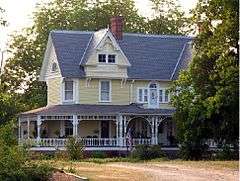
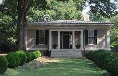
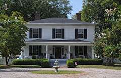
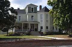
Andrews-Moore House |
|
000000001998-12-10-0000December 10, 1998
(#98001506) |
95 Simon Collie Rd.
36°00′09″N 78°11′14″W / 36.0025°N 78.187222°W / 36.0025; -78.187222 (Andrews-Moore House) |
Bunn |
House burned down on March 29, 2006.
|
| 2 |
Baker Farm |
Upload image |
000000001982-10-05-0000October 5, 1982
(#82001297) |
SW of Bunn on SR 1720
35°56′59″N 78°18′50″W / 35.949722°N 78.313889°W / 35.949722; -78.313889 (Baker Farm) |
Bunn |
|
| 3 |
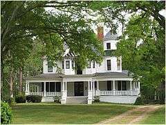
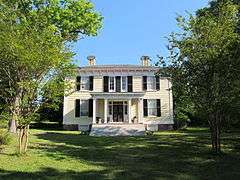
Cascine |
|
000000001973-04-26-0000April 26, 1973
(#73001342) |
S of Louisburg on SR 1702; also the northern side of NC 1702
36°02′21″N 78°19′25″W / 36.039167°N 78.323611°W / 36.039167; -78.323611 (Cascine) |
Louisburg |
Second set of boundaries represents a boundary increase of 000000001985-12-04-0000December 4, 1985
|
| 4 |
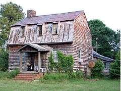
Clifton House and Mill Site |
Upload image |
000000001980-04-17-0000April 17, 1980
(#80002835) |
SR 1103
36°00′05″N 78°21′00″W / 36.001389°N 78.35°W / 36.001389; -78.35 (Clifton House and Mill Site) |
Royal |
|
| 5 |
Cooke House |
Upload image |
000000001975-10-14-0000October 14, 1975
(#75001265) |
SW of Louisburg near jct. of SR 1114 and SR 1109
36°03′19″N 78°20′23″W / 36.055278°N 78.339722°W / 36.055278; -78.339722 (Cooke House) |
Louisburg |
|
| 6 |
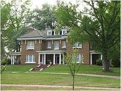
Archibald H. Davis Plantation |
Upload image |
000000001975-07-24-0000July 24, 1975
(#75001266) |
SE of Louisburg off NC 581
36°03′12″N 78°11′45″W / 36.053333°N 78.195833°W / 36.053333; -78.195833 (Archibald H. Davis Plantation) |
Justice |
|
| 7 |
Dean Farm |
Upload image |
000000001975-05-02-0000May 2, 1975
(#75001267) |
6 miles E of Louisburg on NC 56
36°05′21″N 78°10′46″W / 36.089167°N 78.179444°W / 36.089167; -78.179444 (Dean Farm) |
Louisburg |
|
| 8 |
Franklin County Training School-Riverside Union School |
Upload image |
000000002012-01-04-0000January 4, 2012
(#11001011) |
53 W. River Rd.
36°05′41″N 78°18′24″W / 36.094594°N 78.306711°W / 36.094594; -78.306711 (Franklin County Training School-Riverside Union School) |
Louisburg |
|
| 9 |
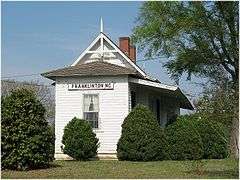
Franklinton Depot |
|
000000001990-12-27-0000December 27, 1990
(#90001941) |
201 E. Mason St.
36°06′11″N 78°27′20″W / 36.103056°N 78.455556°W / 36.103056; -78.455556 (Franklinton Depot) |
Franklinton |
|
| 10 |
Fuller House |
|
000000001978-11-17-0000November 17, 1978
(#78001954) |
307 N. Main St.
36°06′13″N 78°17′58″W / 36.103611°N 78.299444°W / 36.103611; -78.299444 (Fuller House) |
Louisburg |
|
| 11 |
Green Hill House |
|
000000001975-06-10-0000June 10, 1975
(#75001268) |
S of Louisburg near jct. of SR 1760 and 1761
36°04′51″N 78°18′19″W / 36.080833°N 78.305278°W / 36.080833; -78.305278 (Green Hill House) |
Louisburg |
|
| 12 |
Dr. J. H. Harris House |
|
000000001975-08-01-0000August 1, 1975
(#75001260) |
312 E. Mason St.
36°06′15″N 78°27′04″W / 36.104167°N 78.451111°W / 36.104167; -78.451111 (Dr. J. H. Harris House) |
Franklinton |
|
| 13 |
William A. Jeffreys House |
Upload image |
000000001976-06-23-0000June 23, 1976
(#76001323) |
SE of Youngsville on SR 1101
35°57′22″N 78°23′41″W / 35.956111°N 78.394722°W / 35.956111; -78.394722 (William A. Jeffreys House) |
Youngsville |
|
| 14 |
Jones-Wright House |
Upload image |
000000001992-03-12-0000March 12, 1992
(#92000149) |
NC 1003 W side, 0.2 miles S of jct. with NC 1252
36°12′44″N 78°20′54″W / 36.212222°N 78.348333°W / 36.212222; -78.348333 (Jones-Wright House) |
Rocky Ford |
|
| 15 |
Shemuel Kearney House |
|
000000001975-06-05-0000June 5, 1975
(#75001261) |
1 miles S of Franklinton on U.S. 1
36°04′36″N 78°28′53″W / 36.076667°N 78.481389°W / 36.076667; -78.481389 (Shemuel Kearney House) |
Franklinton |
House was moved to Louisburg in 2009.
|
| 16 |
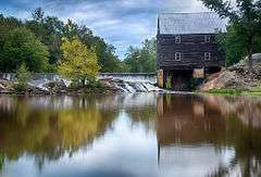
Laurel Mill and Col. Jordan Jones House |
|
000000001975-05-30-0000May 30, 1975
(#75001262) |
SW of Gupton at jct. of SR 1432 and 1436
36°10′40″N 78°11′30″W / 36.177778°N 78.191667°W / 36.177778; -78.191667 (Laurel Mill and Col. Jordan Jones House) |
Gupton |
|
| 17 |
Locust Grove |
Upload image |
000000001975-11-20-0000November 20, 1975
(#75001269) |
N of Louisburg on U.S. 401
36°10′31″N 78°17′26″W / 36.175278°N 78.290556°W / 36.175278; -78.290556 (Locust Grove) |
Ingleside |
|
| 18 |
Louisburg Historic District |
|
000000001987-02-18-0000February 18, 1987
(#87000041) |
Roughly bounded by Allen Lane, Main and Cedar Sts., Franklin, Elm, and King St.
36°06′12″N 78°17′57″W / 36.103333°N 78.299167°W / 36.103333; -78.299167 (Louisburg Historic District) |
Louisburg |
|
| 19 |
Main Building, Louisburg College |
|
000000001978-12-08-0000December 8, 1978
(#78001955) |
Louisburg College campus
36°06′17″N 78°18′00″W / 36.104722°N 78.3°W / 36.104722; -78.3 (Main Building, Louisburg College) |
Louisburg |
|
| 20 |
Massenburg Plantation |
|
000000001975-07-30-0000July 30, 1975
(#75001270) |
Address Restricted; also 821 NC 561
36°07′06″N 78°16′08″W / 36.118333°N 78.268889°W / 36.118333; -78.268889 (Massenburg Plantation) |
Louisburg |
821 NC 561 represents a boundary increase of 000000002000-03-15-0000March 15, 2000
|
| 21 |
C.L. and Bessie G. McGhee House |
Upload image |
000000002007-09-05-0000September 5, 2007
(#07000903) |
103 W. Mason St.
36°06′13″N 78°27′34″W / 36.103611°N 78.459444°W / 36.103611; -78.459444 (C.L. and Bessie G. McGhee House) |
Franklinton |
|
| 22 |
Monreath |
Upload image |
000000001975-08-06-0000August 6, 1975
(#75001264) |
S of Ingleside on NC 39
36°10′00″N 78°17′34″W / 36.166667°N 78.292778°W / 36.166667; -78.292778 (Monreath) |
Ingleside |
|
| 23 |
Dr. Samuel Perry House |
|
000000001975-06-05-0000June 5, 1975
(#75001263) |
East of Gupton on SR 1436
36°11′52″N 78°09′06″W / 36.197778°N 78.151667°W / 36.197778; -78.151667 (Dr. Samuel Perry House) |
Gupton |
|
| 24 |
Perry School |
Upload image |
000000002011-01-03-0000January 3, 2011
(#10001110) |
2266 Laurel Mill-Centerville Rd.
36°11′35″N 78°07′28″W / 36.193056°N 78.124444°W / 36.193056; -78.124444 (Perry School) |
Centerville vicinity |
|
| 25 |
Person Place |
|
000000001972-06-19-0000June 19, 1972
(#72000962) |
603 N. Main St.
36°06′22″N 78°17′46″W / 36.106139°N 78.296231°W / 36.106139; -78.296231 (Person Place) |
Louisburg |
|
| 26 |
Person-McGhee Farm |
|
000000001979-06-26-0000June 26, 1979
(#79003343) |
US 1
36°09′36″N 78°27′11″W / 36.16°N 78.453056°W / 36.16; -78.453056 (Person-McGhee Farm) |
Franklinton |
|
| 27 |
Portridge |
Upload image |
000000001990-03-01-0000March 1, 1990
(#90000351) |
SR 1224, 0.3 miles N of jct. with NC 56
36°05′25″N 78°21′04″W / 36.090278°N 78.351111°W / 36.090278; -78.351111 (Portridge) |
Louisburg |
|
| 28 |
Rose Hill |
Upload image |
000000002006-05-03-0000May 3, 2006
(#06000339) |
W side of US 401 S, 0.25 miles N of NC 1110
36°04′15″N 78°19′54″W / 36.070833°N 78.331667°W / 36.070833; -78.331667 (Rose Hill) |
Louisburg |
|
| 29 |
Dr. J. A. Savage House |
Upload image |
000000001980-09-22-0000September 22, 1980
(#80002834) |
124 College St.
36°05′55″N 78°27′27″W / 36.098611°N 78.4575°W / 36.098611; -78.4575 (Dr. J. A. Savage House) |
Franklinton |
House was demolished in 1997.
|
| 30 |
Speed Farm |
Upload image |
000000001991-12-27-0000December 27, 1991
(#91001907) |
W side NC 1436 between NC 1432 and NC 1434
36°11′17″N 78°11′26″W / 36.188056°N 78.190556°W / 36.188056; -78.190556 (Speed Farm) |
Gupton |
|
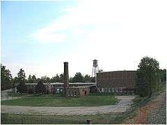
| 31 |
Sterling Cotton Mill |
|
000000001996-05-16-0000May 16, 1996
(#96000568) |
SE jct. of Seabord RR tracks and E. Green St.
36°05′59″N 78°27′25″W / 36.099722°N 78.456944°W / 36.099722; -78.456944 (Sterling Cotton Mill) |
Franklinton |
|
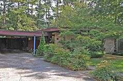
| 32 |
Archibald Taylor House |
|
000000001975-05-12-0000May 12, 1975
(#75001273) |
Address Restricted
|
Wood |
|
| 33 |
Patty Person Taylor House |
|
000000001975-02-13-0000February 13, 1975
(#75001271) |
Address Restricted
|
Louisburg |
|
| 34 |
Aldridge H. Vann House |
|
000000002008-01-09-0000January 9, 2008
(#07001373) |
115 N Main St.
36°06′20″N 78°27′23″W / 36.105556°N 78.456389°W / 36.105556; -78.456389 (Aldridge H. Vann House) |
Franklinton |
|
| 35 |
Vine Hill |
|
000000001975-05-28-0000May 28, 1975
(#75001259) |
Address Restricted
|
Centerville |
|
| 36 |
Thomas and Lois Wheless House |
|
000000002007-08-28-0000August 28, 2007
(#07000887) |
106 John St.
36°06′01″N 78°17′44″W / 36.100278°N 78.295556°W / 36.100278; -78.295556 (Thomas and Lois Wheless House) |
Louisburg |
|
| 37 |
Williamson House |
|
000000001975-06-20-0000June 20, 1975
(#75001272) |
401 Cedar St.
36°06′03″N 78°17′45″W / 36.100833°N 78.295833°W / 36.100833; -78.295833 (Williamson House) |
Louisburg |
|

.jpg)
.jpg)


.jpg)