| [3] |
Name on the Register[4] |
Image |
Date listed[5] |
Location |
City or town |
Description |
|---|
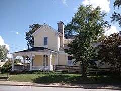
| 1 |
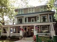
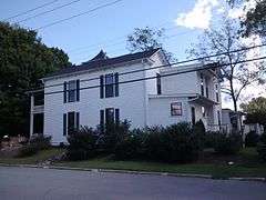
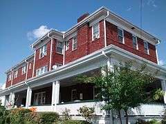
Aloah Hotel |
|
000000001989-02-24-0000February 24, 1989
(#89000036) |
201 3rd Ave. West
35°18′57″N 82°27′41″W / 35.315833°N 82.461389°W / 35.315833; -82.461389 (Aloah Hotel) |
Hendersonville |
|
| 2 |
Berkeley Mills Ballpark |
Upload image |
000000002016-09-19-0000September 19, 2016
(#16000646) |
69 Balfour Rd.
35°20′58″N 82°28′13″W / 35.349396°N 82.470416°W / 35.349396; -82.470416 (Berkeley Mills Ballpark) |
Hendersonville |
|
| 3 |
Brookland |
Upload image |
000000001982-08-19-0000August 19, 1982
(#82003467) |
North of Flat Rock on SR 1863
35°18′10″N 82°26′57″W / 35.302778°N 82.449167°W / 35.302778; -82.449167 (Brookland) |
Flat Rock |
|
| 4 |
Bryn Avon |
Upload image |
000000001999-04-09-0000April 9, 1999
(#99000437) |
Junction of River Rd. and Mallett Rd.
35°17′48″N 82°34′14″W / 35.296667°N 82.570556°W / 35.296667; -82.570556 (Bryn Avon) |
Etowah |
|
| 5 |
Camp Arrowhead |
Upload image |
000000002005-12-16-0000December 16, 2005
(#05001415) |
Cabin Creek Rd., 1 mile (1.6 km) west of junction with Green River Rd.
35°12′47″N 82°28′34″W / 35.213056°N 82.476111°W / 35.213056; -82.476111 (Camp Arrowhead) |
Tuxedo |
|
| 6 |
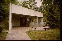
Carl Sandburg Home National Historic Site |
|
000000001968-10-17-0000October 17, 1968
(#68000013) |
West of Flat Rock
35°16′04″N 82°27′06″W / 35.267778°N 82.451667°W / 35.267778; -82.451667 (Carl Sandburg Home National Historic Site) |
Flat Rock |
|
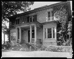
| 7 |
The Cedars |
|
000000001989-02-24-0000February 24, 1989
(#89000033) |
219 7th Ave. West
35°19′10″N 82°27′47″W / 35.319444°N 82.463056°W / 35.319444; -82.463056 (The Cedars) |
Hendersonville |
|
| 8 |
Chewning House |
|
000000001989-02-24-0000February 24, 1989
(#89000034) |
755 N. Main St.
35°19′14″N 82°27′41″W / 35.320556°N 82.461389°W / 35.320556; -82.461389 (Chewning House) |
Hendersonville |
|
| 9 |
Clarke-Hobbs-Davidson House |
|
000000001989-02-24-0000February 24, 1989
(#89000031) |
229 5th Ave. West
35°19′04″N 82°27′44″W / 35.317778°N 82.462222°W / 35.317778; -82.462222 (Clarke-Hobbs-Davidson House) |
Hendersonville |
|
| 10 |
Cold Spring Park Historic District |
Upload image |
000000002009-01-08-0000January 8, 2009
(#08001291) |
Bounded roughly by N. Main St. on the north, Maple St. on the east, 9th Ave. E. on the south, and Locust St. on the west
35°19′29″N 82°27′39″W / 35.324708°N 82.460858°W / 35.324708; -82.460858 (Cold Spring Park Historic District) |
Hendersonville |
|
| 11 |
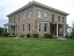
Mary Mills Coxe House |
Upload image |
000000001994-08-26-0000August 26, 1994
(#94001052) |
1210 Greenville Hwy.
35°17′50″N 82°27′05″W / 35.297222°N 82.451389°W / 35.297222; -82.451389 (Mary Mills Coxe House) |
Hendersonville |
|
| 12 |
Druid Hills Historic District |
Upload image |
000000002000-08-16-0000August 16, 2000
(#00000989) |
Roughly bounded by Meadowbrook Terrace, US 25 north, Ashwood Rd., and Ridgewood Ave.
35°19′49″N 82°28′16″W / 35.330278°N 82.471111°W / 35.330278; -82.471111 (Druid Hills Historic District) |
Hendersonville |
|
| 13 |
Flat Rock Historic District |
|
000000001973-10-15-0000October 15, 1973
(#73001352) |
West of East Flat Rock; Roughly bounded by Rutledge, Dunroy & N. Highland Lake Drs., Kanuga, Little River & W. Blue Ridge Rds.
35°16′18″N 82°27′41″W / 35.271667°N 82.461389°W / 35.271667; -82.461389 (Flat Rock Historic District) |
Flat Rock |
Second set of addresses represents a boundary adjustment February 27, 2015
|
| 14 |
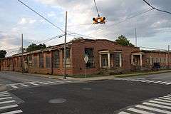
Grey Hosiery Mill |
|
000000002000-10-06-0000October 6, 2000
(#00001189) |
301 Fourth Ave. E
35°19′03″N 82°27′29″W / 35.3175°N 82.458056°W / 35.3175; -82.458056 (Grey Hosiery Mill) |
Hendersonville |
|
| 15 |
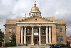
Henderson County Courthouse |
|
000000001979-05-10-0000May 10, 1979
(#79001723) |
1st and Main Sts.
35°18′52″N 82°27′37″W / 35.314444°N 82.460278°W / 35.314444; -82.460278 (Henderson County Courthouse) |
Hendersonville |
|
| 16 |
Hyman Heights-Mount Royal Historic District |
Upload image |
000000002001-02-16-0000February 16, 2001
(#01000124) |
Roughly bounded by Ridgecrest Pl., Highland Ave., Hyman Ave., Patton St., N. Main St., and Oakland St.
35°19′38″N 82°27′53″W / 35.327222°N 82.464722°W / 35.327222; -82.464722 (Hyman Heights-Mount Royal Historic District) |
Hendersonville |
|
| 17 |
Kanuga Lake Historic District |
Upload image |
000000001995-08-31-0000August 31, 1995
(#95001056) |
Roughly, area surrounding Kanuga Lake
35°15′43″N 82°31′11″W / 35.261944°N 82.519722°W / 35.261944; -82.519722 (Kanuga Lake Historic District) |
Hendersonville |
|
| 18 |
King-Waldrop House |
|
000000001989-06-28-0000June 28, 1989
(#89000030) |
103 S. Washington St.
35°18′53″N 82°27′45″W / 35.314722°N 82.4625°W / 35.314722; -82.4625 (King-Waldrop House) |
Hendersonville |
|
| 19 |
Lenox Park Historic District |
Upload image |
000000002002-12-31-0000December 31, 2002
(#02001661) |
Roughly bounded by Allen, Spring, and S. Whitted Sts., and Southern RR.
35°18′36″N 82°28′06″W / 35.31°N 82.468333°W / 35.31; -82.468333 (Lenox Park Historic District) |
Hendersonville |
|
| 20 |
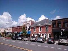
Main Street Historic District |
|
000000001989-03-30-0000March 30, 1989
(#89000028) |
Main St. between Sixth Ave. East and First Ave. East
Boundary increase (listed 000000002006-12-20-0000December 20, 2006): Roughly N. Main St., 2nd Ave., W., W. Allen St., N. Washington, and 1st Ave., E.
35°18′59″N 82°27′37″W / 35.316389°N 82.460278°W / 35.316389; -82.460278 (Main Street Historic District) |
Hendersonville |
|
| 21 |
The Meadows |
|
000000001980-01-11-0000January 11, 1980
(#80002847) |
North of Fletcher on SR 1547
35°26′11″N 82°29′41″W / 35.436389°N 82.494722°W / 35.436389; -82.494722 (The Meadows) |
Fletcher |
|
| 22 |
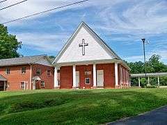
Mills River Chapel |
|
000000001988-12-02-0000December 2, 1988
(#88002660) |
SR 1328, 0.7 miles (1.1 km) north of junction with NC 280
35°23′04″N 82°34′39″W / 35.384444°N 82.5775°W / 35.384444; -82.5775 (Mills River Chapel) |
Mills River |
|
| 23 |
Arthur W. Moore House |
Upload image |
000000002001-01-04-0000January 4, 2001
(#00001613) |
299 Sunset Dr.
35°20′29″N 82°31′39″W / 35.341389°N 82.5275°W / 35.341389; -82.5275 (Arthur W. Moore House) |
Horse Shoe |
|
| 24 |
Moss-Johnson Farm |
Upload image |
000000001987-02-10-0000February 10, 1987
(#87000021) |
3346 Haywood Rd.
35°21′34″N 82°30′32″W / 35.359444°N 82.508889°W / 35.359444; -82.508889 (Moss-Johnson Farm) |
Hendersonville |
|
| 25 |
Oakdale Cemetery |
Upload image |
000000002014-02-05-0000February 5, 2014
(#13001158) |
N. & S. sides of 6th Ave., W., W. of Valley St.
35°19′11″N 82°28′27″W / 35.31973°N 82.474292°W / 35.31973; -82.474292 (Oakdale Cemetery) |
Hendersonville |
|
| 26 |
Reese House |
|
000000001995-06-02-0000June 2, 1995
(#95000676) |
202 S. Washington St.
35°18′46″N 82°27′44″W / 35.312778°N 82.462222°W / 35.312778; -82.462222 (Reese House) |
Hendersonville |
|
| 27 |
Clough H. Rice House |
Upload image |
000000002011-12-27-0000December 27, 2011
(#11000974) |
219 Stoney Mountain Rd.
35°20′19″N 82°28′35″W / 35.338731°N 82.476417°W / 35.338731; -82.476417 (Clough H. Rice House) |
Hendersonville |
|
| 28 |
Rugby Grange |
|
000000001987-05-05-0000May 5, 1987
(#86003748) |
Address Restricted
35°25′15″N 82°31′15″W / 35.420861°N 82.520810°W / 35.420861; -82.520810 (Rugby Grange) |
Fletcher |
|
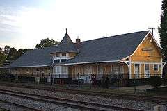
| 29 |
Seventh Avenue Depot District |
|
000000001989-03-30-0000March 30, 1989
(#89000029) |
Seventh Ave. between Grove and Ash
35°19′18″N 82°27′27″W / 35.321667°N 82.4575°W / 35.321667; -82.4575 (Seventh Avenue Depot District) |
Hendersonville |
|
| 30 |
Dillard B. and Georgia Sewell House |
Upload image |
000000002015-04-15-0000April 15, 2015
(#15000164) |
64 Clipper Ln.
35°15′36″N 82°36′15″W / 35.26°N 82.6042°W / 35.26; -82.6042 (Dillard B. and Georgia Sewell House) |
Penrose |
Extends into Transylvania County
|
| 31 |
Singletary-Reese-Robinson House |
Upload image |
000000002010-09-16-0000September 16, 2010
(#10000754) |
211 Robinson Ln.
35°18′38″N 82°29′57″W / 35.310556°N 82.499167°W / 35.310556; -82.499167 (Singletary-Reese-Robinson House) |
Laurel Park |
|
| 32 |
Smith-Williams-Durham Boarding House |
Upload image |
000000001989-02-24-0000February 24, 1989
(#89000032) |
247 5th Ave. West
35°19′03″N 82°27′46″W / 35.3175°N 82.462778°W / 35.3175; -82.462778 (Smith-Williams-Durham Boarding House) |
Hendersonville |
|
| 33 |
Erle Stillwell House |
Upload image |
000000002001-11-20-0000November 20, 2001
(#01000125) |
1300 Pinecrest Dr.
35°19′05″N 82°28′43″W / 35.318056°N 82.478611°W / 35.318056; -82.478611 (Erle Stillwell House) |
Hendersonville |
|
| 34 |
Erle Stillwell House II |
Upload image |
000000002002-09-06-0000September 6, 2002
(#02000933) |
541 Blythe St.
35°19′03″N 82°28′41″W / 35.3175°N 82.478056°W / 35.3175; -82.478056 (Erle Stillwell House II) |
Hendersonville |
|
| 35 |
The Waverly |
|
000000001989-02-24-0000February 24, 1989
(#89000035) |
783 N. Main St.
35°19′15″N 82°27′42″W / 35.320833°N 82.461667°W / 35.320833; -82.461667 (The Waverly) |
Hendersonville |
|
| 36 |
West Side Historic District |
Upload image |
000000002001-12-31-0000December 31, 2001
(#01001424) |
Roughly bounded by Fifth Ave. W., Washington St., Third Ave. W., and Blythe St.
35°18′56″N 82°28′12″W / 35.315556°N 82.47°W / 35.315556; -82.47 (West Side Historic District) |
Hendersonville |
|
.jpg)